
Remediation and Restoration Projects for the Grand Calumet River AOC
On this page:
- Remedial Investigation Project Highlight: Grand Calumet River – Eastern 5 Miles
- Remediation Project Highlight: Junction Reaches
- Remediation Project Highlight: Lake George Middle and East
- Restoration Project Highlight: Dune, Swale and Shelf Wetlands Restoration
- Table of Remediation and Restoration Projects
More on Grand Calumet River AOC
Remediation Project Highlight: Junction Reaches
The Junction Reaches project is divided into three sections: the Indiana Harbor Ship Canal (IHC) south of Columbus Drive, the West Branch of the Grand Calumet River (WBGCR) between Indianapolis Boulevard and the IHC, and the East Branch of the Grand Calumet River (EBGCR) between the IHC and Kennedy Avenue. In partnership with the East Chicago Waterway Management District, Atlantic Richfield Company, and British Petroleum, U.S. EPA will address beneficial use impairments (BUIs) in the Grand Calumet River by dredging and capping contaminated sediments within the project area.
The project will consist of specialized dredging in the IHC to remove sediment with high concentrations of polychlorinated biphenyls (PCBs), dredging and capping the WBGCR and IHC, and capping the EBGCR. Construction activities are scheduled to begin in Fall 2026. Habitat restoration activities are also being planned on the adjacent wetlands to provide habitat for waterfowl and help link the previously restored Roxana Marsh to the wetland complex east of Kennedy Avenue.
This project will decrease legacy contaminants released into the Great Lakes, improve aquatic habitat in the river and adjacent wetlands, improve water quality in the river and canal, and increase opportunities for recreational use of the waterways.
This project will contribute to removing 9 of the AOC’s 12 remaining BUIs, including, but not limited to:
- Restrictions on Fish and Wildlife Consumption
- Tainting of Fish and Wildlife Flavor
- Fish Tumors or Other Deformities
- Bird or Animal Deformities or Reproduction Problems
- Degradation of Benthos
- Restrictions on Dredging Activities
Remedial Investigation Project Highlight: Grand Calumet River – Eastern 5 Miles
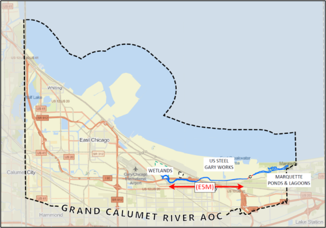
U.S. EPA's Great Lakes National Program Office (GLNPO) is partnering with U.S. EPA Region 5’s Land Chemicals and Redevelopment Division (LCRD) and the United States Steel Corporation (USS) to evaluate the nature and extent of sediment contamination within the "Eastern 5 Miles" of the Grand Calumet River Area of Concern (AOC). This project area is in Gary, Indiana and includes the Marquette Park Lagoons. Sediment, surface water, and porewater samples have been collected from the lagoons, river channel, and nearby wetlands. The project is partially funded under the authority of the EPA’s Great Lakes Legacy Act through funding provided by the Infrastructure Investment and Jobs Act (IIJA).
The Eastern 5 Miles of the Grand Calumet River is directly adjacent to USS' Gary Works facility. Gary Works is a nearly 4000-acre, fully integrated steel mill that has been operational since 1908 and the subject of RCRA Corrective Action since 1998. The sediments within the Eastern 5 Miles project area have been impacted by both industrial and municipal source inputs over time and may be contributing to beneficial use impairments (BUI) throughout the AOC. Historical data from this area indicates sediments have been impacted by heavy metals, PAHs, and PCBs. Together, U.S. EPA and USS are planning to collect more environmental samples which will help make cleanup decisions that contribute to removing BUIs, delisting the AOC, and restoring ecosystem health.
In November 2023, U.S. EPA and USS signed a Great Lakes Legacy Act project agreement to conduct sampling and a feasibility study of remedial alternatives for Eastern 5 Miles sediment. The first phase of sampling occurred in summer of 2024 and the second phase in summer of 2025. Data resulting from both phases of sampling will inform the scope of future work and aid in developing a feasibility study of remedial alternatives. These efforts are the first steps in what is envisioned to be a significant environmental cleanup that will leverage funding from the Infrastructure Investment and Jobs Act (IIJA), as well cost-share contributions from USS.
This project will address the following BUIs:
- Restrictions on fish and wildlife consumption
- Degradation of fish and wildlife populations
- Fish tumors or other deformities
- Bird or animal deformities or reproduction problems
- Degradation of benthos (organisms living at the bottom of bodies of water)
- Loss of fish and wildlife habitat
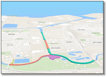
Remediation Project Highlight: Lake George Canal Middle and East
In partnership with the East Chicago Waterway Management District, Atlantic Richfield Company, and BP Products North America, this project will remediate approximately 190,000 cubic yards of contaminated sediment by dredging the East Portion and capping the Middle Portion of the Lake George Canal. Dredged material will be placed in the Indiana Harbor Confined Disposal Facility (CDF). Where removal is not feasible, an engineered cap will immobilize contaminants and separate them from the food chain.
Fact Sheet: Lake George Branch - Middle Section Remediation (pdf)
The East Portion of the canal extends from Indianapolis Blvd to the CSX railroad bridge in East Chicago, Ind. Much of this area is within a federal navigation channel. So far, a USACE contractor has completed Phase 1 of the dredging and removed nearly 25,000 cubic yards of contaminated sediment, placing it in a CDF. Next, Phase 2 dredging will be designed and carried out to remediate an additional 85,000 cubic yards of contaminated sediment. The Middle Portion of the canal extends from the CSX bridge to the BP land bridge in Hammond, Ind. Construction for this portion was largely completed in 2023, addressing 224,000 cubic yards of contaminated sediment. Monitoring of the site will continue through 2027, and additional remediation activities may occur in 2028, including additional remediation of the canal banks and sediment cap maintenance activities.
The removal and containment of contaminated sediment will prevent PAHs, PCBs, heavy metals, oil, and other contaminants from entering the food chain and will both help bring back fish populations in the river and lower the risk of exposure to these contaminants for those who eat the fish. Once completed, improvements to habitat along the shoreline will provide better shelter for fish and wildlife.
Restoration Project Highlight: Dune, Swale and Shelf Wetlands Restoration
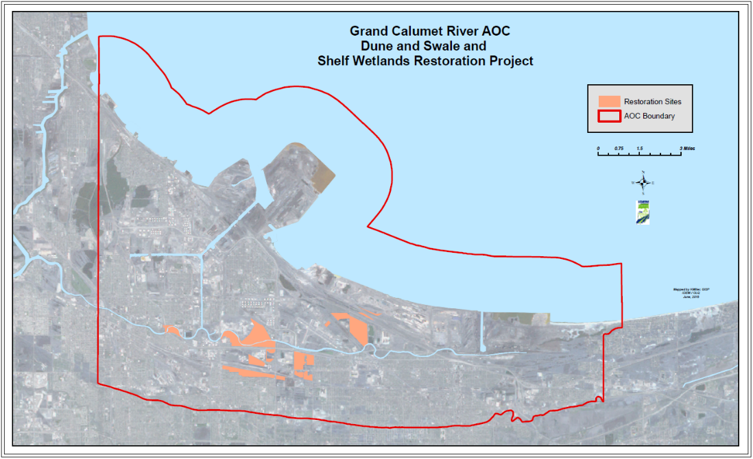
In partnership with the Indiana Department of Environmental Management, the Indiana Department of Natural Resources, the Nature Conservancy, and the Lake County Parks and Recreation Department, the GLRI-funded Dune and Swale Wetlands Restoration project is restoring dune, swale, and shelf wetland habitat — a globally rare habitat. The habitat is home to many important species such as the Karner blue butterfly, Blanding’s turtle, spotted turtle, and various migratory birds.
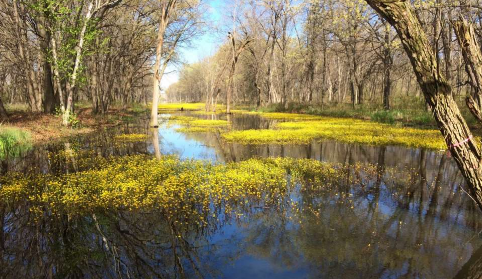
The project will restore at least 900 acres of state- and locally- managed habitat throughout 15 sites in the Grand Calumet AOC. Phase 1 began in 2015 and in 2021 transitioned over to the second and final phase. It is anticipated that this work will be completed by 2026. The project’s main objective is to control dense areas of woody and herbaceous (non-woody) nuisance and invasive plant species such as phragmites. Controlling these invasive species will improve the structure and quality of dune, swale, and shelf wetland habitat and benefit native species, leading to increased fish and wildlife populations in the AOC.
This project addresses the below BUIs:
- Degradation of Fish and Wildlife Populations
- Loss of Fish and Wildlife Habitat
Table of Remediation and Restoration Projects
| Project Title | Project Description | Date Completed | Targeted BUI(s) |
|---|---|---|---|
| Great Lakes Legacy Act – East Branch Phase II | Project includes dredging and capping of the East Branch of the Grand Calumet River, approximately between the Old Cline Avenue bridge and the railroad bridge near Municipal Drive. The project also includes ecosystem restoration of adjacent wetlands, and initial closure activities for the Ralston Street Lagoon sludge disposal pit. | 2030 (est.) |
|
| Great Lakes Legacy Act – Orphan Areas | The Orphan Areas are located within the Indiana Harbor Ship Canal but outside of the federal navigation channel routinely dredged by the U.S. Army Corps of Engineers. These areas contain high levels of legacy contamination, and the EPA is identifying potential remediation measures in collaboration with the Corps and the State of Indiana. | 2030 (est.) |
|
| Great Lakes Legacy Act - Junction Reaches | Project includes dredging and capping of Junction Reaches. This project will also incorporate habitat restoration activities on adjacent wetlands. | 2028 (est.) |
|
| Great Lakes Legacy Act – Lake George Canal East and Middle Sections Remedial Action | Phase 1 included dredging the eastern portion of the Lake George Canal and removing nearly 25,000 cubic yards of contaminated sediment. Phase 2 is in planning and is estimated to remediate an additional 84,000 cubic yards. Remediation was also completed for 115,000 cubic yards of contaminated sediment in the middle portion of the canal, for a total of approximately 224,000 cubic yards. | 2028 (est.) |
|
| Pine Station | The project will restore habitat in Pine Station Nature Preserve to ensure its ecological health. This project will control bank erosion and invasive vegetation, install sand caps over toxic fly ash, and construct a wetland planted with emergent and submergent plants. | 2028 (est.) |
|
| Dune, Swale, and Shelf Wetlands Restoration Phase 1 and 2 | The project is restoring globally rare dune and swale habitat and riverine wetlands through the control of woody and herbaceous invasive species. | 2026 (est.) |
|
| Prescribed Fire Implementation | This project is using prescribed fire as a tool for controlling invasive plant species and promoting the re-establishment of native species on over 700 acres of habitat. | 2022 |
|
| Lake George Wetlands Restoration | Herbicide application and invasive species control improved ~80 acres of wetland habitat surrounding the Lake George branch of the Indiana Harbor Canal and George Lake. | 2021 |
|
| Nearshore Bird Management Program at Grand Calumet AOC Beaches | The project mitigated the impacts of nuisance shorebirds and implemented gull management at Lake Michigan beaches within the Grand Calumet River AOC. | 2019 |
|
| Great Lakes Legacy Act - Stateline Remedial Action | The project remediated 46,000 cubic yards of contaminated sediments and restored habitat near the Indiana/Illinois Stateline. Routine monitoring indicates sediment cap repairs are needed. | 2016 (cap repairs est. 2028) |
|
| Great Lakes Legacy Act - East Branch Remedial Action | This project remediated 1.1 million cubic yards of contaminated sediment and restored habitat between Kennedy and Cline Avenues. Remedial work included deep pool restoration and the revival of shallow marginal wetlands. | 2015 |
|
| Great Lakes Legacy Act – Roxana Marsh, Reaches 1 and 2 Remedial Action | This project dredged and capped 585,000 cubic yards of contaminated sediment in the West Branch of the river and restored 19 acres of migratory bird habitat in Roxana Marsh. | 2012 |
|
| Great Lakes Legacy Act – West Branch, Reaches 3, 4, and 5 Remedial Action | This project dredged and capped ~148,000 cubic yards of contaminated sediment and restored habitat between Hohman and Columbia Avenues. | 2011 |
|