
Visual Plumes
Please see PLUMES2.0 for the current version.
The Visual Plumes model system is a Windows-based software application for simulating surface water jets and plumes. It also assists in the preparation of mixing zone analyses, Total Maximum Daily Loads (TMDLs), and other water quality applications.
A demonstration of how Visual Plumes was applied to Lake Pontchartrain flood water discharge after Hurricane Katrina is available below.
| Current Version: | 1.0 |
|---|---|
| Release Date: | August 2001 |
| Development Status: | General Release |
| Development Information: | Release Notes - changes and known deficiencies |
| Operating System: | Win 95/98/NT/2000/XP ( Not supported beyond Windows XP ) |
| Development Language: | Visual Basic |
| Intended Audience: | Scientist/Engineer |
| Key Words: | surface, water, jet, plume, model, quality, contaminant, TMDL |
| Related Web Sites: | None Available |
| File Name | File Description |
|---|---|
| ABSTRACT.TXT | Summary of functions, theory, and applicability. |
| README.TXT | Important installation and usage information. |
| File Type / Priority |
File Name / Format / Size |
File Description |
|---|---|---|
| Install / Required |
INSTALL VPLUME.EXE / Self-extracting Zip / 5.6 MB |
Setup file for version 1.0 of the Visual Plumes system. Use this for new installs. See README.TXT for installation instructions. |
| Update / Optional |
UPDATE VPLUME.EXE / Self-extracting Zip / 0.6 MB |
Components needed to update to the most recent version (August 14, 2001). Use only with a previously installed version of Visual Plumes. See README.TXT for installation instructions. |
| Document / Recommended |
VP-Manual.pdf / Adobe Acrobat / 5.2 MB |
Dilution Models for Effluent Discharges, 4th Edition (Visual Plumes) (PDF, 148 pp., 5.2 MB, about PDF). |
Hurricane Katrina Modeling Demonstration
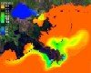
In the aftermath of Hurricane Katrina and the subsequent repair of dikes protecting New Orleans, water was pumped from flooded sections of the city into Lake Pontchartrain and other water bodies as part of the drying of the city. Under an ongoing CRADA collaboration between EPA and Battelle, a decision was made to contribute to post-Katrina recovery efforts by applying collective experience to the Lake Pontchartrain discharge. Simulations of expected tidal movements and associated salinity, using the Finite Volume Coastal Ocean Model, a public domain model adopted for another modeling application, are the product of this work. In this demonstration, a 48-hour simulation traces the impact of polluted water and suspended sediment discharged during pumping from Lake Pontchartrain into the Mississippi Sound. The distribution of sea salt is the first step to assessing how well a modeling study reproduces actual water transport and dispersion. Indirectly, the movement of the discharged brackish water can be used to help evaluate the impact of these contaminant flows on the wetlands and ecosystems along the coast of Gulf of America.
Hurricane Katrina Modeling Animation (Self-extracting Zip, 38 MB Compressed, 71 MB Extracted)