Pollution Accountability Team
Communities along the Mississippi River in Louisiana’s St. James, St. John the Baptist and Calcasieu Parishes live with a high concentration of pollution-emitting industrial facilities. Administrator Michael Regan visited the area to hear from residents during his Journey to Justice tour, and promised them EPA would take action to reduce their burden. One of the most important follow-up actions was forming the Pollution Accountability Team (PAT) to enhance enforcement of existing regulations in these communities.
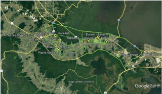
The PAT used a full range of enforcement technology and methods to more fully assess the types and levels of pollution coming from these facilities. Using input from community members, EPA and LDEQ enforcement staff took mobile air monitors along routes near facilities and in neighborhoods to screen for excess or unauthorized emissions of volatile organic compounds (VOCs) and specific hazardous air pollutants (HAPs). The enforcement teams used these screening results to target certain facilities for on-site investigations.
The results of the monitoring and the inspection reports can be accessed using the links below. Additionally, a Story Map was created to help visualize monitoring results. If the link above does not work, please copy the following web address into your web browser:
https://storymaps.arcgis.com/stories/187cdbea879543b5bfadc5cd15f057cf
Monitoring Conducted

Geospatial Measurement of Air Pollution (GMAP)
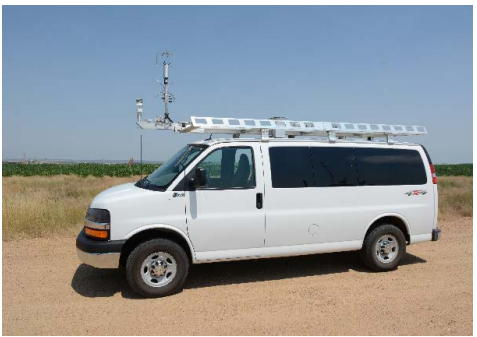
The GMAP is a mobile monitoring unit equipped with scientific instruments that can measure certain pollutants. The data GMAP collects is used to create maps that EPA uses to identify potential sources of emissions. The GMAP information was used by teams of inspectors to focus ground investigations at specific facilities.
GMAP Reports and FLIR Video Links
- GMAP R6 Pollution Accountability Team Report EO3: NEICVP1456E03 Replacement Report (pdf) (10.23 MB, April 11-23, 2022)
- GMAP R6 Pollution Accountability Team Report EO4: NEICVP1456E04 Replacement Report (pdf) (672.26 KB, April 11-23, 2022)
- GMAP FLIR Video links
- MOV_0181: https://youtu.be/3R9BIEmMTYo
- MOV_0182: https://youtu.be/cd59UqPqwqo
- MOV_0183: https://youtu.be/J_ZmEzUmUbA
- MOV_0184: https://youtu.be/z5VIhXqfyDI
- MOV_0185: https://youtu.be/yikWD-aQD4Y
- MOV_0186: https://youtu.be/kIkQl4yLDxk
- MOV_0187: https://youtu.be/Jyvuisrtq9M
- MOV_0188: https://youtu.be/AQ_dEgadd5k
- MOV_0191: https://youtu.be/GwOeF9VWd1U
- MOV_0204: https://youtu.be/HCoDhOVbc4g
- MOV_0205: https://youtu.be/7lhqJWj_tXY
- MOV_0206: https://youtu.be/WUlcRoRxuws

Airborne Spectral Photometric Environmental Collection Technology (ASPECT)
ASPECT is a small plane equipped with monitoring and imaging equipment that can conduct aerial screening for over 76 different chemicals. The ASPECT will monitor facilities in the same area as the GMAP and the information collected will be shared with the inspection teams on the ground.
- ASPECT Journey to Justice Assessment Louisiana 18-21 April 2022 (docx) (6.75 MB, May 16, 2022)
Facility Inspection Teams

EPA inspection teams accompanied the GMAP and conducted facility inspections during the field effort. The facility inspectors were equipped with handheld infrared cameras, photoionization detectors, and gas meters. The GMAP operators and facility inspection teams evaluated monitoring data collected by the GMAP and ASPECT to determine where follow up investigations and inspections were conducted.
Facility Inspection reports by parish (Links to all pdfs of inspection reports)

Monitoring Results

Monitoring data
- GMAP data visualization tool
- Google Earth Pro (GEP) is a free software program that may be downloaded and installed from the internet at https://www.google.com/earth/versions/. The KML files produced by the GMAP software are designed to be visualized by Google Earth Pro, although many other geographical information systems (GIS) will also be able to import and visualize these files. See Appendix D of the GMAP report for directions designed to help new users understand the information present in the KML files and use Google Earth Pro to visualize this information
- For detailed descriptions of Instrumentation, Calibrations, and Data Quality Assurance, please refer to the GMAP Reports. Please note that measurements are relative to the instrument’s baseline that has the potential to drift during the day, so individual measurements should be examined with care before concluding the presence of an elevated concentration. For that reason, trends or sustained spikes in the instrument measurements need to be considered and may often be of greater value in identifying excess or unauthorized emissions.
- KML files by date
- Air canister sampling (pdf) (1.33 MB, April 19-26, 2022)
Enforcement and Compliance Assurance Documents for Louisiana
Although all inspection reports and enforcement actions in the state of Louisiana can be found here, select PAT related enforcement actions will be highlight below.
- Evonik
- The U.S. Environmental Protection Agency (EPA) reached a settlement with Evonik Corporation that will reduce emissions of ethylene oxide and other hazardous air pollutants by 5.6 tons per year from a facility in Reserve, St. John the Baptist Parish, Louisiana. The alleged violations were found as a result of a special monitoring and enforcement effort by officials from EPA and the Louisiana Department of Environmental Quality (LDEQ) following EPA Administrator Michael Regan’s visit to the area during his Journey to Justice tour.
Citizens can call the toll-free line at 800-887-6063 or email R6_SJB@epa.gov
James Leathers
EPA Region 6 Air Toxics Program
214.665.6569
or email
leathers.james@epa.gov
Steve Thompson
EPA Region 6 Air Enforcement Program
214-665-2769
or email
thompson.steve@epa.gov
All inquiries from the news media should be directed to the EPA Region 6 Press Office at 214.665.2200 or email R6press@epa.gov.
