Water in Louisiana
On this page:
- Water Topics
- Lake Pontchartrain Basin Restoration Program
- Coastal Wetlands Planning, Protection & Restoration Act (CWPPRA)
- Ocean Dumping
- Louisiana NPDES Permits
- Louisiana Department of Environmental Quality Nonpoint Source Pollution Program
- National Estuary Program
Water Topics
When the water in our rivers, lakes, and oceans becomes polluted; it can endanger wildlife, make our drinking water unsafe, and threaten the waters where we swim and fish. EPA research supports efforts under the Clean Water Act and Safe Drinking Water Act.
Please visit EPA's main Water Topics page for more information.
Lake Pontchartrain Basin Restoration Program
The Lake Pontchartrain Basin Restoration Program (PRP) invites interested parties to participate in the Program's Stakeholder Meetings and programmatic decisions.
Please visit the Lake Pontchartrain Basin Restoration page for more information.
The Coastal Wetlands Planning, Protection & Restoration Act (CWPPRA) Program
The EPA Region 6 Coastal Wetlands Planning, Protection and Restoration Act (CWPPRA) program team works with federal, state, and local partners to develop, design, and build Louisiana coastal restoration projects. Since 1990, EPA has sponsored the engineering, design, and construction of projects benefiting some 13,000 acres of restored or protected wetlands, marshes, headlands, and barrier islands.
EPA adopted the NOAA Restoration PEIS for CWPPRA projects. EPA Region 6 posted a notice of availability on April 21, 2023 that the EPA intended to adopt the NOAA Restoration PEIS for CWPPRA projects. After a 30-day comment period, the EPA signed a Record of Decision and the Inclusion Form.
EPA-Sponsored Restoration Projects
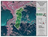
Reggio Marsh Creation (BS-43)
The Reggio Marsh Creation and Hydrologic Restoration project (BS-43) will create and nourish approximately 519 acres of marsh located along the Delacroix Highway (LA 300) near the town of Reggio, Louisiana. This project area has experienced wetland loss due to a variety of factors including subsidence, saltwater intrusion, and storm damage. Hurricane Katrina devastated the area resulting in substantial marsh loss which has exposed infrastructure to open water conditions. Storm-driven erosion in the area continued from Hurricane Rita (2005), Hurricane Isaac (2012), Tropical Storm Barry (2019), Hurricane Zeta (2020), and Hurricane Ida (2021). This project addresses wetland loss in the area east of Reggio by restoring the structural framework of the marsh by filling in open water areas with dredged sediments. This project will serve as an important buffer to protect this coastal community from storm surge and restore wetland habitat.
The Environmental Protection Agency (EPA) is the federal sponsor for the BS-0043 “Reggio Marsh Creation” project. The project is funded through the Coastal Wetlands Planning, Protection, and Restoration Act (CWPPRA) and has completed Phase I Engineering and Design and has been funded for Phase 2 Construction. Final NEPA documentation for the BS43 Reggio Marsh Creation project appear below. Please contact Dr. Sharon L. Osowski (osowski.sharon@epa.gov) if you have questions or are unable to download the files below.
- BS43 NEPA Inclusion Form and Summary (pdf)
- BS43 NEPA Inclusion Form Appendix A (pdf)
- BS43 NEPA Inclusion Form Appendix B (pdf)
- BS43 NEPA Inclusion Form Appendix C (pdf)
- BS43 NEPA Inclusion Form Appendix D (pdf)
- BS43 NEPA Inclusion Form Appendix E (pdf)
- BS43 NEPA Inclusion Form Appendix F (pdf)
Port Fourchon Marsh Creation (TE-171)
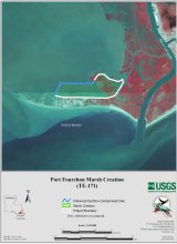
EPA’s newest project, Port Fourchon Marsh Creation (TE-171) is situated at the tip of Lafourche Parish. The project area is bounded by Bayou Lafourche to the east and Timbalier Bay to the west. This project will create and nourish approximately 543 acres of wetlands by hydraulically dredging sediment from a borrow source in Belle Pass.
Port Fourchon took a direct hit when Hurricane Ida made landfall in 2021, devastating the area with further wetland degradation and exposing infrastructure to open water conditions. This port is a crucial economic driver for both Louisiana and the nation. Restoration projects will build the area’s defenses against hurricanes and flooding. EPA’s project partner is the Louisiana Coastal Protection and Restoration Authority. Learn more about the project in the CWPPRA Port Fourchon Marsh Creation (TE-171) Fact Sheets. TE-171 has completed Phase I Engineering and Design and has been funded for Phase 2 Construction. The Final NEPA documentation for the TE-171 Port Fourchon Marsh Creation project appear below. Please contact Paul Kaspar (Kaspar.Paul@epa.gov) if you have questions or are unable to download the files below.
- TE171 NEPA Inclusion Form and Summary (pdf)
- TE171 NEPA Inclusion Form Appendix A (pdf)
- TE171 NEPA Inclusion Form Appendix B (pdf)
- TE171 NEPA Inclusion Form Appendix C (pdf)
- TE171 NEPA Inclusion Form Appendix D (pdf)
- TE171 NEPA Inclusion Form Appendix E (pdf)
- TE171 NEPA Inclusion Form Appendix F (pdf)
- TE171 NEPA Inclusion Form Appendix G (pdf)

Long Point Bayou Marsh Creation (CS-85)
The Long Point Bayou Marsh Creation project (CS-85) will create approximately 400 acres of marsh approximately four miles south of Hackberry, north of the Sabine National Wildlife Refuge, east of Highway LA 27, and west of the Calcasieu Ship Channel near Mile 11.
The area has experienced wetland loss due to salt water intrusion, water fluctuations, and erosion. This project will beneficially use sediments dredged from the Calcasieu Ship Channel and will also create tidal creeks and ponds in the project footprint, which will aid the Endangered Species Act proposed saltmarsh topminnow. The project is currently in Phase 1: Engineering and Design.
Read more about the Long Point Bayou Marsh Creation (CS-85) project.
Caminada Headland Back Barrier Marsh Creation (BA-171)
The Caminada Headland Back Barrier Marsh Creation project was combined with the BA-193 “Increment 2” project to create approximately 900 acres of marsh habitat. The project creates a platform for sand from other beach and dune projects. If not for this platform, the sand would be lost to open water as it continually rolls back due to tides and other processes. Construction began in June 2020 with containment dikes and dredging was completed in October 2022.
Read more about the Caminada project and watch the video!

Hydrologic Restoration and Vegetative Planting in the des Allemands Swamp (BA-34-2)
Construction was completed in 2018. This is the first CWPPRA project to restore a cypress-tupelo swamp.
Repairing the area’s natural hydrology improved the health of existing trees by providing needed periods of flooding and drying. To jump-start the process, 300 water tupelo and 900 bald cypress trees were planted. This final piece of the restoration project stabilized the soil and helped replace dying mature cypress and tupelo trees.
Construction of this project took about five months at a cost of just over $500,000. The project enhanced 2,395 acres of swamp habitat in St. James Parish bordered by Bayou Chevreuil that would have otherwise continued to degrade.
Read more about the des Allemands Swamp project and watch the video!

Bayou Dupont
EPA has sponsored two projects in the Bayou Dupont area of Plaquemines and Jefferson Parishes. The Mississippi River Sediment Delivery System-Bayou Dupont project (BA-39) was the first project under the Coastal Wetlands Planning, Protection and Restoration Act (CWPPRA) to use dredged sediment from the Mississippi River for marsh creation and to establish a reusable pipeline delivery system. The second project, Bayou Dupont Sediment Delivery - Marsh Creation and Terracing #3 (BA-164), was EPA’s first use of terraces in a restoration project.
Read more about the Bayou Dupont projects and watch the video!
EPA Restoration of Louisiana Barrier Islands
Since 1990, EPA has constructed six barrier island restoration projects in the Isles Dernieres chain. Each project demonstrated an innovative restoration feature or concept. Barrier islands serve an important function by acting as a first line of defense for coastal communities against storm surge.
More About CWPPRA
EPA Region 6 is one of five federal agencies working with the State of Louisiana to restore coastal Louisiana wetlands. Louisiana’s coastal zone contains approximately 30 percent of coastal marshes and 45 percent of all intertidal coastal marshes in the lower 48 States, but it is suffering 80 percent of the entire nation’s annual coastal wetland loss. Since the 1930s, coastal Louisiana has lost more than 1,883 square miles, an area more than 25 times larger than Washington, D.C. Louisiana’s wetlands provide a variety of benefits that serve the nation across an array of economic sectors. Because of this, the coastal wetland loss crisis in Louisiana is considered a matter of national concern.
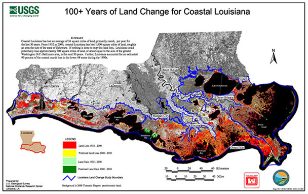
Working with our State, Federal and local partners, EPA Region 6 implements restoration projects to promote coastal protection at a landscape scale and reduce the vulnerability of coastal habitats to the effects of subsidence, erosion, sea level rise, and storm surge. CWPPRA project managers, engineers, and scientists use various techniques to protect, enhance, or restore wetlands. EPA Region 6 has sponsored and completed various types of projects including "natural" reintroduction of river water, barrier island/shoreline restoration, and application of innovative technologies such as pipeline delivery of new sediment. Additional information on CWPPRA is at http://www.lacoast.gov.
Ocean Dumping
Region 6’s Ocean Dumping Management Program plays an essential role in keeping our oceans safe and clean, while supporting the marine transportation system and the economy. Region 6 serves Arkansas, Louisiana, New Mexico, Oklahoma, Texas and 66 tribes. Region 6 encompasses the ocean waters offshore of Louisiana and Texas.
Please visit Managing Ocean Dumping in Region 6 for more information.
Louisiana NPDES Permits
In Louisiana, EPA issues NPDES permits on tribal lands. For more information, please contact EPA Region 6. All other permits are issued by the Louisiana Dept. of Environmental Quality.
For state-issued permits, visit Louisiana Pollutant Discharge Elimination System (LPDES).
For stormwater permits, visit NPDES Stormwater Program in Region 6.
For offshore oil and gas permits, visit Western and Central Gulf of America Offshore Oil & Gas NPDES Program.
| Location | Facility of Permit Name | Permit Number | Effective Date | Expiration Date |
|---|---|---|---|---|
| Coushatta | Coushatta Casino Resort WWTP | LA0124656 | Nov. 1, 2021 | Oct. 31, 2026 |
| Chitimacha | Chitimacha Casino Resort | LA0050971 | Mar. 1, 2022 | Feb. 28, 2027 |
Louisiana Nonpoint Source (NPS) Pollution Program
Louisiana's Nonpoint Source (NPS) Pollution Program is managed by the Louisiana Department of Environmental Quality (LDEQ), and is a collaborative effort that includes many partners. NPS is a type of water pollution that is not generated from a discrete conveyance, such as a discharge pipe, but is generated during rainfall events. NPS pollution is the largest remaining type of water pollution that needs to be addressed within Louisiana and across the nation in order to restore the designated uses to the impaired waterbodies.
Please visit LDEQ Nonpoint Source webpage for more information.
National Estuary Program
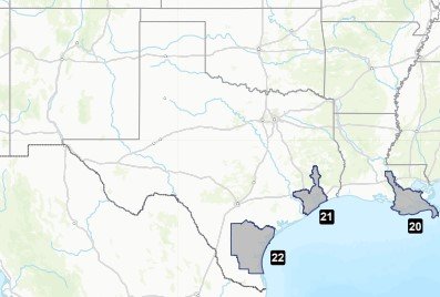
The National Estuary Program NEP is a collaborative, efficient, and adaptable ecosystem-based network of organizations that protects and restores 28 estuaries of national significance. The Louisiana Estuary Program in region 6 is in the Barataria-Terrebonne National Estuary Program (20) in southeast Louisiana. In region 6, Texas has the Galveston Bay Estuary Program (21) in the southeast corner of Texas and the Coastal Bend Bays and Estuaries Program (22) in south Texas. The local estuary program websites are linked under the Explore Local Estuary Programs on the National Estuary Program website.
Map of Region 6 Estuary Program Locations
