Big River Mine Tailings National Priorities List (NPL) Superfund Site, St. Francois County, Missouri – Fact Sheet, October 2021
Operable Unit Status

Site Overview
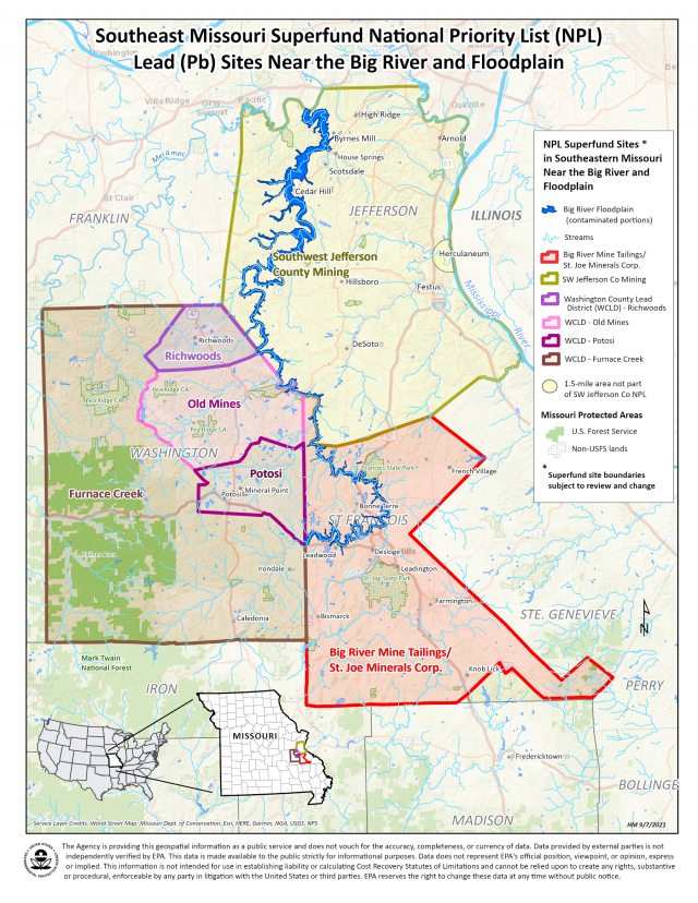
The Big River Mine Tailings National Priorities List (NPL) Superfund Site (site) in St. Francois County, Missouri, is located within the Old Lead Belt, which was one of the world’s largest lead mining districts where mining began in the early 1700s, having produced more than 9 million tons of lead. (See map at right.) Mining activities, including smelting, milling and roasting, contaminated the site.
Lead mine waste has been dispersed throughout the area from water and wind erosion, and spread as residential fill material, applied as treatment on icy roads, and used as agricultural lime. Those distributions, along with historic releases directly from the mine waste piles, contributed to the contamination of the Big River and were transported downstream and spread onto the floodplain. This site was added to the NPL in 1992, and is divided into five main project areas, also known as Operable Units (OUs). If you live or recreate along the Big River, you are at risk of being exposed to lead and other toxic metals. The site is being addressed through federal, state, and Potentially Responsible Party (PRP) actions. Activity and use limitations known as institutional controls are also established.
Lead is a toxic metal that is harmful if inhaled or swallowed and can pose serious health risks, particularly to children 7 years old and younger, as well as pregnant women and nursing mothers. Lead is the primary contaminant of concern at this site. Children 7 years old and younger are most at risk from developing lifelong disabilities and problems from lead exposure. Children are more sensitive to lead than adults, and it is important that children in this age range be tested annually. For free lead testing for children, contact the St. Francois County Health Center, 1025 West Main Street, Park Hills, Missouri; by phone at 573-431-1947; or by visiting the St. Francois County Health Center website.
Source Areas (OU-00)
The disposal of mining waste rock on-site created very large piles (also known as source areas) of mine tailings/chat that have eroded with time, due to wind and water. Mining waste has also been mechanically transported throughout the site.
Dust created by wind erosion also contaminated the surrounding area and was a potential hazard to residents. There are eight, large mining waste pile sites that span approximately 110 square miles in size; they include the following sub-sites: 1) Bonne Terre Mine Tailings, 2) Leadwood Mine Tailings, 3) Elvins Mine Tailings (also known as Rivermines), 4) Federal Tailings Pile, 5) Desloge Mine Tailings (also known as Big River), 6) Doe Run Mine Tailings, 7) National Mine Tailings, and 8) Hayden Creek.

Six of the source areas have been addressed through PRP actions, such as reducing the slope and height, regrading, covering/capping, revegetating, improving the structural stability, and preventing sloughing (flowing) into the river. The remaining two areas will be addressed by future actions.
Residential Yards (OU-01)
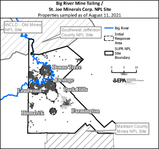
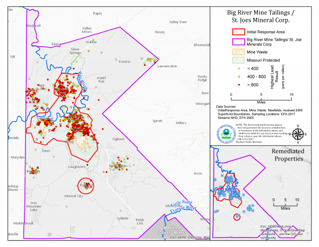
The county maps (see Properties Sampled and Remediated Properties maps at right) illustrate the site boundaries, area of the initial response area, and over 5,820 residential properties that have been tested for lead contamination. To date, over 1,940 residential yards have been remediated, along with all contaminated schools, child care facilities, and Head Start Early Childhood Centers (since work began in 2000). Cleanup work is ongoing, and EPA and the PRPs will continue to sample and remediate properties with greater than 400 parts per million (ppm) lead content. If your property has not been tested and you would like to have your soil and/or groundwater analyzed, please contact EPA. There is no cost to the property owner.

Big River and Floodplain (OU-02)
The Big River is used for recreational purposes such as fishing and canoeing, as well as for commercial activities such as watering livestock. In 1977, heavy rains caused an estimated 50,000 cubic yards of lead mining tailings (also known as chat) to slough off (flow) into the river. This event and other ongoing releases have contaminated the Big River and floodplain. If you live or recreate along the Big River, you are at risk of being exposed to lead and other toxic metals. The state of Missouri advises people not to eat fish they catch from the Big River downstream of the site. Check local fish advisories. The Remedial Investigation (RI) and Feasibility Study (FS) of the river is ongoing and a decision on the cleanup has not yet been determined. EPA expects to complete an Interim Record of Decision in late 2022.
Interim Program/Halo Removal (OU-03)
U-3 consisted of the Interim Program and Halo Removal Action (RA) to address elevated blood lead levels at the site. The Interim Program included sampling and remediation of yard sections with greater than 2,000 ppm lead content at properties within 1 mile of the source areas. The “Halo” was defined as the area within 500 feet of the source areas, 1,000 feet from four identified smelters/calciners, and 100 feet from the mine shafts. The Halo RA included sampling and remediation of residential properties and high child exposure areas (i.e., playgrounds and day cares) with greater than 400 ppm lead content. This action was completed in 2018.
Rail Lines (OU-04)
OU-4 focuses on the associated rail lines in St. Francois County. Rail lines that are associated with the existing OUs will be characterized during the RI/FS, which is scheduled for completion in 2026. A PRP search will be initiated in fall 2021.
Doe Run Mine Tailings (OU-05)
OU-5 focuses on the existing waste at the Doe Run Mine Tailings Superfund Site and its associated downstream impacts. It is a potential candidate for use as a repository for material remediated as part of the Big River OU1 Superfund Site remediation. OU5 will be characterized during the RI/FS, which is scheduled for completion in 2024.
Additional Site and Lead Information
- The Administrative Records for the site are available in the online repository at EPA's Site Profile Page (see Site Documents & Data).
- For information about Technical Assistance and Grants, please contact EPA.
- Residential Yard Cleanup Fact Sheet
- Fact Sheet about the Big River and Floodplain Project
- Other Fact Sheets about this site and a site map are available on EPA's Missouri Cleanups page.
- For more information about lead, visit CDC’s Lead page and EPA's Lead page.
EPA Contact Information
Contact EPA for more information about community involvement and to receive site updates:
Elizabeth Kramer
Community Involvement Coordinator
U.S. EPA Region 7 (ORA/OPA)
11201 Renner Boulevard
Lenexa, KS 66219
Phone: 913-551-7186
Toll-free: 1-800-223-0425
Email: kramer.elizabeth@epa.gov
Jason Gunter
Remedial Project Manager
U.S. EPA Region 7 (SEMD/LMSE)
11201 Renner Boulevard
Lenexa, KS 66219
Phone: 913-551-7358
Toll-free: 1-800-223-0425
Email: gunter.jason@epa.gov
