
EPA Projects Aim to Improve Ozone Models Over Long Island Sound
Published February 9, 2021
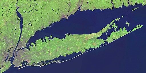
The natural beauty and vibrant ecosystems of Long Island Sound make this coastal area a hotspot for tourism, fishing, and birdwatching. While its unique features make the tidal estuary a great place to visit, its geography also creates the perfect conditions for an ozone hotspot.
Wedged between New York's Long Island and Connecticut, Long Island Sound's proximity to urban areas makes it vulnerable to air pollutants. Across the New York City metropolitan area, ground-level ozone concentrations frequently exceed the National Ambient Air Quality Standards (NAAQS) because of emissions from traffic and other sources common to cities. This is despite efforts to curb the emissions that form ozone in the atmosphere.
As pollutants from New York City and other regional sources drift over the sound, atmospheric science takes over. Lower water temperature cools the air above, causing it to sink and trap the air pollutants like a lid covering a pot of water. The plume of trapped air is then drawn inland on sea breezes towards Connecticut's shores. This ozone plume impacts millions of people living downwind in Connecticut and occasionally as far away as Rhode Island and Massachusetts.
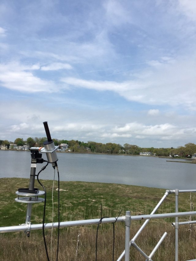
In the summer of 2018, a group of eight states making up the Northeast States for Coordinated Air Use Management (NESCAUM) launched a field study to investigate ozone formation over the ocean and transport across Long Island Sound. Called the Long Island Sound Tropospheric Ozone Study (LISTOS), the research brought EPA scientists together with federal, state, and academic partners to collect air quality data. LISTOS combined measurements from ground sensors, satellites, and aircraft instruments to gather comprehensive data on pollutants contributing to the ozone plume, as well as how they were mixing in the atmosphere.
Now, EPA scientists are using this data to improve air quality models, including the Agency’s CMAQ model used by states to implement the National Ambient Air Quality Standards (NAAQS). These improvements will create a more accurate picture of ozone pollution in the regions surrounding Long Island Sound as well as how ozone forms and moves across the region. More accurate modeling will allow air quality managers and regulators identify emissions sources contributing to high ozone levels.
Dr. Jonathan Pleim, who leads the modeling project, says one goal is to conduct modeling at a high level of detail to see how it compares to the observations from the previous field study. Models with higher resolution allow users to simulate atmospheric chemical processes more accurately and down to smaller, more locally relevant scales—like zooming in to the street level view on Google Maps.
The researchers expect this high-resolution modeling will be useful for air quality management.
"For the larger community, another one of our goals is to evaluate the model to show that it's a useful tool for developing emission control strategies," Dr. Pleim said.
While much of the ozone plume is related to emissions from New York City, researchers are still trying to determine how much may come from other sources. The modeling efforts will help answer this and other questions about the causes of high ozone episodes.
The research team has already had success improving the model's ability to simulate weather conditions, which affect how ozone forms in the air and where it travels. More accurate simulations of sea breezes and where layers of air mix in the atmosphere will provide better predictions of ozone conditions across the affected region.
Informing Air Pollution Reduction Strategies
EPA air quality regulators and scientists are also collaborating to evaluate the accuracy of the model configuration typically used to make air quality management decisions. This configuration draws on CMAQ to model atmospheric chemistry, as well as the Biogenic Emissions Inventory System (BEIS) and the 2016v1 Platform models, which account for emissions. Once completed, the project will help decision-makers identify and prioritize emissions sources to address in order to achieve the greatest ozone reductions.
"We hope to better understand how much impact emissions sources in the New York City area have on days that exceed the NAAQS and whether these emissions may be more important to target for controls than in places upwind of Long Island Sound," said Dr. Kirk Baker, an EPA physical scientist and the project lead.
Once the researchers are confident in the model's performance, they will use it to identify emissions sources and predict where emissions reductions would have the biggest impact on ozone levels. This information will help state air quality managers better target emissions sources, which the researchers hope will result in less ozone production on days that traditionally favor high levels of ozone.
"This project has been successful in part due to the enormous effort of the scientists on the team who coordinated the field study among a multitude of different stakeholder groups including state agencies, federal partners like NOAA and NASA, and academic groups," Dr. Baker said.