
EPA Scientists Develop Interactive Tool that Provides Water Quality Information about U.S. Freshwater Resources
Published August 10, 2021
Freshwater is essential for life on our planet, providing drinking water and supporting agriculture, industry, and aquatic life. This lifeline connects humans and ecosystems with the resources they need to prosper, so when freshwater degrades, it can have significant consequences. To better understand the quality of our freshwaters, EPA scientists have developed Freshwater Explorer, an interactive web-based mapping tool that provides information about background and observed salt and mineral content for freshwater streams, lakes, and wells in all 50 U.S. states, Puerto Rico, and the U.S. Virgin Islands. The tool provides water quality information to help federal, state, territory, tribal, and local partners make decisions about freshwater resources, and can be used by anyone to better understand national and local water quality issues.
Freshwater, found in lakes, rivers, streams, and other water bodies, contains low concentrations of dissolved mineral ions, including phosphate, nitrate, sodium, and chloride. Increases in minerals and ion levels sometimes indicate a source of pollution in freshwater systems. Higher levels of minerals in the water can cause harmful algal blooms and affect aquatic wildlife. These conditions can increase costs for making water suitable for drinking by people and livestock, as well as for use in agricultural and industrial processes, and water reuse.
Freshwater Explorer uses data from EPA’s Water Quality Portal and includes water quality data records from more than 500 federal, state, and tribal partners. The tool allows users to quickly access and visualize predicted background salt and mineral levels for approximately 2.65 million stream segments of a few kilometers each. The tool includes summary statistics for observed salinity and mineral levels for approximately 289,000 stream locations, 10,000 lakes, and 50,000 wells. New water quality parameters, such as phosphorus, will be added to Freshwater Explorer later this year.
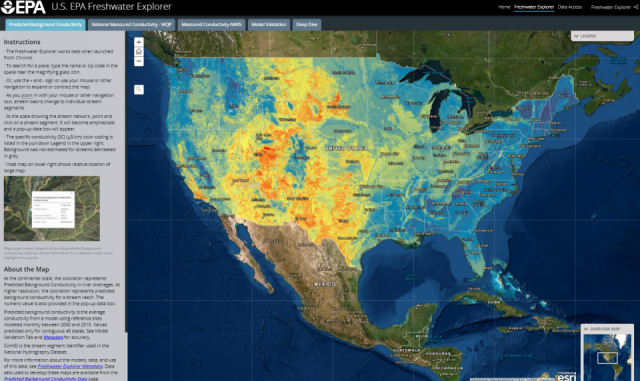
Data in Freshwater Explorer is color-coded to display specific information about water quality. Users can additionally conduct geographical searches, access information about how maps and water quality values are estimated, and access datasets and published papers.
Background water quality data in Freshwater Explorer are estimated based on a variety of factors, including geology, climate, soil, and vegetation. This background water quality data allows users to view how salinity and other nutrient measurements taken in various watersheds differ from estimated background levels in Freshwater Explorer. Users can conduct their own geographical searches in Freshwater Explorer and use the tool’s map-centric features to display and compare background and measured data for various water quality parameters. This information can be helpful for states when working with communities to find the right balance of protection and use of freshwater resources.
“I can’t wait to see how schools, clubs, and communities of all sizes use this information to bring awareness of the importance of freshwater,” Cormier said.
Freshwater Explorer is mobile-friendly and works on all screen sizes, ranging from desktop computers to tablets and mobile phones. The tool works best when launched with Google Chrome. Users can also download Freshwater Explorer and add their own datasets using ArcGIS software.
Ultimately, Freshwater Explorer provides data that can assist communities in better understanding national and local water quality issues.
Learn More