
Water Infrastructure and Capacity Assessment Tool
Data Update: Service Line Inventory data now available in Water ICAT plus routine data refreshes.
January 2026—Water ICAT now includes the newly released Service Line Inventory dataset, available as map filters and in downloadable data tables. Learn more about the Service Line Inventory dataset.
- EPA Community Water System Service Area Boundaries Version 2;
- 2025 Q4 compliance data; and
- New, annual State Revolving Fund (SRF) data, covering the period July 1, 2024 – June 30, 2025.
More information about these and other source datasets are available on Water ICAT’s Source Data Information page.
The Water Infrastructure and Capacity Assessment Tool (Water ICAT) is an interactive map that helps users identify drinking water and wastewater utilities that may benefit from water infrastructure technical assistance or capacity development assistance. Water ICAT combines water utility information with compliance, demographic, and water infrastructure funding data allowing users – such as technical assistance providers – to efficiently screen for utilities that may benefit from additional federal, state, or local support.
- Home
- Resources and Tools
- Frequently Asked Questions
Water Infrastructure and Capacity Assessment Tool (Water ICAT)
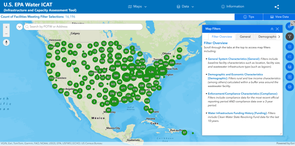
Water ICAT is designed to support users, such as technical assistance providers, in efficiently screening for drinking water and wastewater utilities that may have technical assistance or capacity development assistance needs. Water ICAT does this by incorporating publicly available data from a variety of sources into a single, user-friendly screening tool. Data available within Water ICAT span four primary categories including general utility characteristics, demographic and economic characteristics, enforcement and compliance characteristics, and finally water infrastructure funding history. These data are aggregated at the utility scale.
Water ICAT currently includes Community Water Systems (CWS) for drinking water infrastructure and National Pollutant Discharge Elimination System (NPDES) permitted Publicly Owned Treatment Works (POTWs) for wastewater infrastructure. The limiting factor in not including other infrastructure types (such as, municipal separate storm sewer systems (MS4s), private domestic wells, septic systems, and non-discharging wastewater facilities) is a lack of national data availability. As data availability improves, more water infrastructure types may be added to this tool. For more information, visit Infrastructure Types within Water ICAT.
Use Cases
The most common use for Water ICAT is to identify water utilities that may need technical assistance. Users make map filter selections across the available data categories to identify utilities meeting their screening requirements. Based on the results, users can then ground-truth utility needs by consulting more local information at the state, community, or utility-level. After verifying need, the process of working with utilities to access beneficial resources can begin. Visit the Water ICAT App for more information on Appropriate Uses as well as user guidance under Quick Start Tips.
Water ICAT Data
General Utility Characteristics: Includes baseline utility characteristics such as infrastructure type, utility location, ownership, and population served. Sources: EPA’s Enforcement and Compliance History Online (ECHO) database and the Safe Drinking Water Information System (SDWIS).
Demographic and Economic Characteristics: Includes rural, income, unemployment, and other demographic data. Sources: Decennial Census and American Community Survey.
Water Infrastructure Funding History: Includes Clean and Drinking Water State Revolving Fund Data from the last 10-years. Source: Drinking Water and Clean Water State Revolving Fund Portal.
Caveats and Limitations
- Water ICAT is just one of several resources that can be used to identify potential need and is intended to complement existing resources. Not all utilities identified using this screening tool may require assistance.
- Water ICAT incorporates enforcement and compliance data, however, Water ICAT is not intended to be used as an enforcement targeting tool.
- Not all utilities have adequate spatial or locational data to discern demographic and economic characteristics.
Resources and Tools
Documentation and Data
- Visit Water ICAT to explore the maps and data.
- Complete App details and documentation can be found within the Water ICAT App under the Information tab. Available information includes details on Source Data and Field Names and Appropriate Uses, user guidance under Quick Start Tips, and other topics of interest.
- Water ICAT Fact Sheet (pdf)
- Water ICAT Frequently Asked Questions (pdf)
- For questions, email the RealWaterTA email box (RealWaterTA@epa.gov).
EPA Resources
- About EPA's RealWaterTA program
- List of RealWaterTA programs
- RealWaterTA Request Form (submit a request for TA)
Frequently Asked Questions
What types of water infrastructure are included within Water ICAT?
Water ICAT currently focuses on: (1) Community Water Systems (CWS) for drinking water data, and (2) National Pollutant Discharge Elimination System (NPDES) permitted Publicly Owned Treatment Works (POTWs) for wastewater data.
The limiting factor in not including other infrastructure types (such as, municipal separate storm sewer systems (MS4s), private domestic wells, septic systems, and non-discharging wastewater facilities) is a lack of national data availability. As data availability improves, more water infrastructure types may be added to this tool.
For more information, visit Infrastructure Types within Water ICAT.
What types of data are included in Water ICAT?
Water ICAT includes four primary types of data: (1) General Utility Characteristics, (2) Demographic and Economic Characteristics, (3) Enforcement/Compliance Characteristics, and (4) Water Infrastructure Funding History.
- General Utility Characteristics: Includes baseline utility characteristics, such as, location, population size served or utility size, infrastructure type (for wastewater).
- Demographic/Economic Characteristics: Includes rural, income, unemployment, and other demographic data. These data are included for utilities when adequate spatial data are available to know the actual or approximated service area for a utility. These data provide insight into the population that comprises a utility’s (actual or approximated) service area.
- Enforcement/Compliance Characteristics: Includes compliance data for the most recent official reporting period AND historical compliance data. A facility’s enforcement and compliance history can be used to analyze trends and provide users with additional information on key activities.
- Water Infrastructure Funding History: Includes State Revolving Fund (SRF) data for the last 10 years. Past receipt of SRF funding can provide insight into a utility’s capacity to successfully identify, apply for, and receive funding, although it is important to note that there are other sources of infrastructure funding that are not included within Water ICAT.
For more information, visit Tool Design within Water ICAT.
What spatial data are used to map utilities and characterize their service area?
Water ICAT uses the best available spatial data to map water utilities and characterize population characteristics within a utility service area or utility proximity.
- Drinking Water: Water ICAT incorporates spatial data in two ways for drinking water systems: (1) Water ICAT uses EPA’s Community Water System Service Area Boundary data, when available. (2) When not available, reported data on the county, tribe, or territory served are used, and a point is placed at the centroid of that reported area. Only systems with service area boundary data have demographic and economic characteristics available within Water ICAT.
- Wastewater: Unlike drinking water systems, wastewater facilities in Water ICAT do not have nationally available service area boundary data layers. In the absence of these data, wastewater facilities are displayed as points referring to the locations of the wastewater treatment plants, as reported within ICIS-NPDES (Integrated Compliance Information System-National Pollutant Discharge Elimination System). In the absence of spatial boundary data, Water ICAT calculates demographic and economic characteristics within a one-, three-, and five-mile buffer around the facility.
For more information, visit Spatial Data within Water ICAT.
What are some of the use cases for Water ICAT?
The purpose of Water ICAT is to identify utilities that may need technical assistance. When using Water ICAT, users identify utilities with potential assistance needs by selecting map filters meeting their screening requirements.
Based on the results, users can then ground-truth actual utility needs by consulting more local information at the state, community, or utility-level.
After verifying actual need, the process of working with utilities to access beneficial resources, such as, support through EPA’s RealWaterTA, can begin.
More information on uses of Water ICAT can be found within the app under Appropriate Uses, and user guidance can be found under Quick Start Tips.
How often is data within Water ICAT updated?
Water ICAT always aims to have the most up-to-date data populated within the tool, remaining in-sync with source data updates. Some data, such as, compliance data, are updated quarterly, other data, such as, state revolving fund data, are updated annually. Users can verify the latest compliance data on EPA’s Enforcement and Compliance History Online platform.
Details on data extraction frequencies, data extraction date, and expected next update can be found within the Water ICAT App under Source Data and Field Names.
What are some caveats and limitations?
Water ICAT provides technical assistance providers and related entities a data-driven resource to screen for water utilities that may have water infrastructure or capacity development needs and may benefit from related assistance.
Some caveats and limitations of Water ICAT include:
- Need is a broad term used within Water ICAT, intended to encompass different types of support a utility may benefit from. Not all utilities identified using this screening tool may require assistance.
- Water ICAT is just one of several resources that can be used to identify potential need and is intended to complement existing resources.
- Water ICAT incorporates enforcement and compliance data, however, Water ICAT is not intended to be used as an enforcement targeting tool.
- Water ICAT incorporates screening level data that users should supplement with additional, more localized, information to discern actual need.
- Not all utilities have adequate spatial or locational data to discern demographic and economic characteristics.
More information can be found within Water ICAT under Caveats and Limitations.