U.S. flag

An official website of the United States government

Here’s how you know

Dot gov

Official websites use .gov
A .gov website belongs to an official government organization in the United States.

HTTPS

Secure .gov websites use HTTPS
A lock (LockA locked padlock) or https:// means you’ve safely connected to the .gov website. Share sensitive information only on official, secure websites.

    • Environmental Topics
    • Air
    • Bed Bugs
    • Cancer
    • Chemicals, Toxics, and Pesticide
    • Emergency Response
    • Environmental Information by Location
    • Health
    • Land, Waste, and Cleanup
    • Lead
    • Mold
    • Radon
    • Research
    • Science Topics
    • Water Topics
    • A-Z Topic Index
    • Laws & Regulations
    • By Business Sector
    • By Topic
    • Compliance
    • Enforcement
    • Laws and Executive Orders
    • Regulations
    • Report a Violation
    • Environmental Violations
    • Fraud, Waste or Abuse
    • About EPA
    • Our Mission and What We Do
    • Headquarters Offices
    • Regional Offices
    • Labs and Research Centers
    • Planning, Budget, and Results
    • Organization Chart
    • EPA History

Breadcrumb

  1. Home
  2. Great Lakes AOCs

The Grand Calumet River AOC Boundary Map

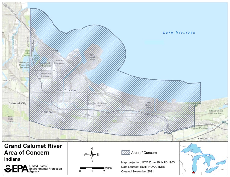
The Grand Calumet River originates on the east side of Gary, Ind., and is comprised of two east-west flowing branches that cover the southern end of the Indiana Harbor Ship Canal. The eastern branch of the river drains into Lake Michigan. The AOC area, which is 22 square miles in total, encompasses portions of the cities of Gary, East Chicago, Hammond, and Whiting, Ind., and is defined by:

  • The Indiana/Illinois state line to the west 
  • Grand Avenue around Marquette Park lagoons in Gary to the east 
  • The southern boundary extending to the Tolleston Beach Ridge 
  • The northern boundary on Lake Michigan which includes a 1.5-mile buffer out into the lake 

The following files are available for download for the Grand Calumet River AOC:

  • Grand Calumet River AOC shapefile (zip)  (zipped) 
  • Grand Calumet River AOC Boundary Map (kmz) (kmz)
  • Grand Calumet River AOC Boundary Map (pdf) (1.16 MB) (pdf)
  • Grand Calumet River AOC Boundary KMZ Metadata (pdf) (221.55 KB)

Great Lakes AOCs

  • The Great Lakes
  • Great Lakes AOCs Home
  • AOC List, Map and Contacts
  • Beneficial Use Impairments
  • Remedial Action Plans
  • Great Lakes Legacy Act
Contact Us About Great Lakes AOCs
Contact Us to ask a question, provide feedback, or report a problem.
Last updated on May 12, 2025
  • Assistance
  • Spanish
  • Arabic
  • Chinese (simplified)
  • Chinese (traditional)
  • French
  • Haitian Creole
  • Korean
  • Portuguese
  • Russian
  • Tagalog
  • Vietnamese
United States Environmental Protection Agency

Discover.

  • Accessibility Statement
  • Budget & Performance
  • Contracting
  • EPA www Web Snapshot
  • Grants
  • No FEAR Act Data
  • Plain Writing
  • Privacy
  • Privacy and Security Notice

Connect.

  • Data
  • Inspector General
  • Jobs
  • Newsroom
  • Regulations.gov
  • Subscribe
  • USA.gov
  • White House

Ask.

  • Contact EPA
  • EPA Disclaimers
  • Hotlines
  • FOIA Requests
  • Frequent Questions
  • Site Feedback

Follow.