
Remediation and Restoration Projects for Maumee AOC
Completed Project Highlights
Otter Creek Legacy Act Cleanup
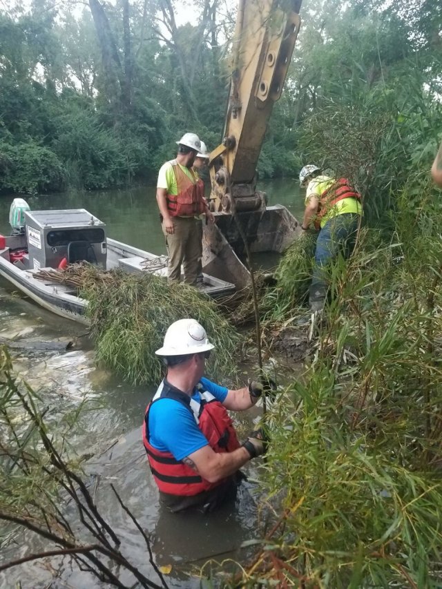
The Otter Creek Legacy Act Cleanup was completed at the end of August 2021 with the installation of habitat improvements. To complete the cleanup, over 50,400 cubic yards of contaminated sediment was dredged from the creek and its confluence and a one-foot sand cover was placed in the creek after dredging.
Otter Creek is a small creek that flows southwest to northeast through the cities of Toledo and Oregon, Ohio, before emptying into South Maumee Bay as part of the Maumee AOC. The lower 1.7 miles of the creek is a highly industrial area containing an active railroad yard, oil refineries, and closed landfills. Currently, municipal and industrial storm water outfalls continue to flow into the creek. Initial sediment testing determined that this area of the creek contained elevated levels of PAHs and Diesel Ran
ge Organics.
In July of 2020, a $10 million Great Lakes Legacy Act Project Agreement amendment for sediment remediation cost share in collaboration with the EPA and three industrial partners was signed. An estimated $4.7 million of the estimated $12 million project total will be contributed by the industrial partners.
Otter Creek GLLA project StoryMap (US ACE)
(March 2021) Fact Sheet: Otter Creek Sediment Cleanup Complete (pdf)
Remediation and Restoration Project Table
| Project Title | Project Description | Date Completed | Targeted BUI(s) |
|---|---|---|---|
|
GLLA- Swan Creek |
The approximately 4 miles of lower Swan Creek sediment is contaminated which negatively affects fish and bug communities. |
2027 (est.) |
|
|
Berlin Avenue Floodplain and Stream Improvements |
Restoration and preservation of 2,200 linear feet of Otter Creek floodway and capture of storm water runoff and associated sediment. |
2025(est.) |
|
|
Crane Creek Lacustuary Wetland Restoration |
Restoration of up to 300 acres of lacustrine wetland habitat. |
2026 (est.) |
|
|
Delaware Creek Park Restoration: Phase II |
Erosion control at a stormwater outfall, and/or installing a vegetated concrete block mat to protect the area while allowing for infiltration and vegetation growth |
2025 (est.) |
|
|
Detwiler Park Stream Restoration |
Creation of instream habitat, improvements to ponds/conversion to wetland, removal of accumulated sediments in stream and ponds, and restoration or reconnection to of waterbodies to the floodplain in a 1-mile stretch of the stream |
2026 (est.) |
|
|
Dry Creek Restoration |
The creation of benches along 1,500 feet of Dry Creek, possible stream channel expansion, and the creation of wetland complexes in the associated floodplain. |
2025 (est.) |
|
|
Oxbow Channel Addition & Wetland Enhancement/Reconnection in the Lacustuary of Turtle Creek |
Enhance 17 acres of wetland habitat, create 1,730 feet of backwater habitat, and create a diversity of wetland types and a nursery environment for fish. |
2026 (est.) |
|
|
Packer Creek Stream Restoration |
Regrade/vegetate 13,000 feet of incised streambank, improving sinuosity for 9,900 feet of channel, and installing 13,000 feet (90 ft wide, 16 acres) of riparian buffer. |
2025 (est.) |
|
|
Schiller Stream and Riparian Improvements |
Stabilize 1,800 feet of eroding streambank, enhancing of 2.8 acres of wetland, and restoring 0.65 acre of riparian buffer. |
2025 (est.) |
|
|
Taylor Rd. and Yarrow St. Floodplain and Stream Improvements |
Restoration of vernal pool/riparian wetland habitat, improvement of instream cover, enhancement of 900 linear feet of riparian buffer, and stormwater runoff capture. |
2025 (est.) |
|
|
UTMC Swan Creek Restoration |
Stabilize 1,700 feet of eroding streambank, installation of locked logs, bendway weirs, hydraulic cover stones, and 50 feet of riffle habitat. |
2025 (est.) |
|
|
Collins Park Improvements on Duck Creek |
Regrade/create streambank benches in stream reaches between culverts and/or creation of a wetland channel in the 2.5-acre area at the upstream end of Duck Creek. |
2026 (est.) |
|
|
Connected Wetland and Fish Passage at Camp Sabroske |
Restore 25 acres of wetland habitat, creating a diversity of wetland types, nursery habitat for fish and increasing connectivity between Toussaint and adjacent wetland. |
2025 (est.) |
|
|
Headwaters Tenmile Creek Stream & Riparian Restoration |
Stabilize 1,200 feet of eroding streambank and enhance and restore 2.5 acres of riparian buffer. |
2025 (est.) |
|
|
Maumee State Forest Blue Creek Stream Restoration |
Regrading/vegetating of 2,500 feet of incised streambank, restoration of 1.3 acres of wetland, and restoration of 2.9 acres of riparian buffer. |
2024 |
|
|
Maumee State Forest Expansion |
A total of 140 acres will be restored by the planting of trees to create oak-dominated woodlands and oak savannahs and establish wet prairies or wet sedge meadows. |
2025 (est.) |
|
|
Restoration of the Ottawa River within Jermain Park |
Creation of 2.7 acres of wetland, stabilization of 2,300 feet of eroding streambank, creation of 50 feet of riffle habitat, and enhancement of 1.5 acres of riparian buffer. |
2025 (est.) |
|
|
Stream Restoration at Oregon Recreational Complex |
Regrade/vegetate 5,300 feet of incised streambank, improving sinuosity along 1,600 feet of channel, restoring ~3.5 acres of floodplain habitat, and installing 2.5 acres of riparian buffer. |
2024 |
|
|
Turtle Creek North Nissen Road Restoration |
Regrade/stabilize 1,100 feet of incised streambank, improving stream sinuosity and installing in-stream cover, creating 50 feet of riffle habitat, and creating 0.75-acre of floodplain wetland. |
2024 |
|
|
Dry Creek Instream and Riparian Restoration (WM) |
Creation of benches along ~650 linear feet of Dry Creek, adding flow length/sinuosity, adding cobble/substrate, and planting native vegetation in riparian areas. |
2025 (est.) |
|
|
Cedar Point NWR Pool 2 |
Restore water management capability to 135 acres of coastal habitat, enhancement of 1,595 acres of coastal wetlands. |
2023 |
|
|
Navarre Unit of Ottawa NWR |
Approximately 600 acres of degraded coastal wetlands were enhanced through upgraded wetland management. |
2023 |
|
|
Howard Marsh Phase 2 |
In 2018, Phase 1 converted 732-acres of the property back into wetland. Phase 2 restored 240-acre of upland forest (20-acre) and coastal marsh (220-acre) and connected the remaining 255 acres of the property. |
2022 |
|
|
Kitty Todd Expansion |
Converted over 280 acres of current row-crop agriculture and 11 acres of residential land cover to Oak Openings habitat and enhanced 17.5 acres of degraded Oak Openings habitat. |
2022 |
|
|
Magee Marsh State Wildlife Area (MMWA) |
Improved management of 2,700 acres of coastal wetland, improved passage of native fish, reduced the threat of non-native invasive plants and animals and improved cost-effectiveness and sustainability. |
2022 |
|
|
Maumee Bay State Park Coastal Wetland |
Creation of 43- acres of wetland, a small dike with a water control/fish passage at the mouth of the wetland to re-establish an aquatic connection with the lake and provide water level management that will be used to control non-native vegetation. |
2022 |
|
|
Oak Savannah Expansion at Secor Metropark |
A total of 39.3 acres restored to native Oak openings prairie and savanna habitat. |
2022 |
|
|
Toussaint East and West |
118.58 acres of land along the south side of the Toussaint 118.58 acres of land along the south side of the Toussaint River and adjacent to the Blausey Unit of Ottawa National Wildlife Refuge was restored to wetlands and upland. |
2022 |
|
|
Fox Property Restoration Project |
30 acres was restored with native wildlife habitats by planting 3.7 acres native short grass, 15 acres native short grass sedge meadow interspersed with scattered trees, and 11 acres of forest. |
2021 |
|
|
GLLA – Lower Maumee River, Sway Bridge and WWTP sites |
Conducted data gap sampling to further characterize the sediments to determine steps, leading to a potential remedial action in the future. |
2021 |
|
|
Otter Creek |
The 1.7-mile section of Otter Creek had contaminated sediment removed and a one-foot sand cover placed to provide a clean substrate for benthic organisms to utilize when re-establishing community populations. |
2021 |
|
|
Penn 7 Wetland Restoration |
Restored 15.2 acres. Installed a new water control structure, restored fish habitat, and increased fish nursery habitat. |
2021 |
|
|
Restoring Coastal Wetlands at Toussaint State Wildlife Area |
Restored 5400 linear feet of the exterior river berm. 2500 linear feet of internal berms was removed to create additional wetland habitat. |
2021 |
|
|
Irwin Upland Prairie Site 5 |
Implemented cleanup on 20 acres of land to remove all previously dumped nonhazardous waste material left behind after a previous 2016 cleanup. |
2018 |
|
|
Irwin Wet Prairie |
40 acres was restored to its former wet prairie habitat. Habitat enhancement activities over 6 acres included removing glossy buckthorn. |
2018 |
|
|
GLLA- Ottawa River |
Addressed 251,000 cubic yards of contaminated sediment and dredged 5.6 miles of the river. 509,000,000 gallons of water was successfully treated and discharged to the river. |
2010 |
|