Mobile Air Survey in KCK and KCMO
EPA Region 7 Survey in Kansas City, Kansas, and Kansas City, Missouri (Kansas City Bi-State Area)
Investigation
Background
EPA Region 7 selected the Kansas City, Kansas, and Kansas City, Missouri, metropolitan area (or Kansas City Bi-State Area) as part of its ongoing Reducing Air Toxics in Vulnerable Communities National Enforcement and Compliance Initiative. The Kansas City Bi-State Area includes neighborhood communities adjacent to dense concentrations of industries, which may subject these communities to disproportionate impacts1 on their health and/or environment.
1 Pursuant to a permanent injunction issued by the U.S. District Court for the Western District of Louisiana on Aug. 22, 2024, EPA will not impose or enforce any disparate-impact or cumulative-impact-analysis requirements under Title VI against any entity in the state of Louisiana. See additional and updated information.
GMAP Survey
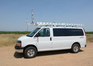
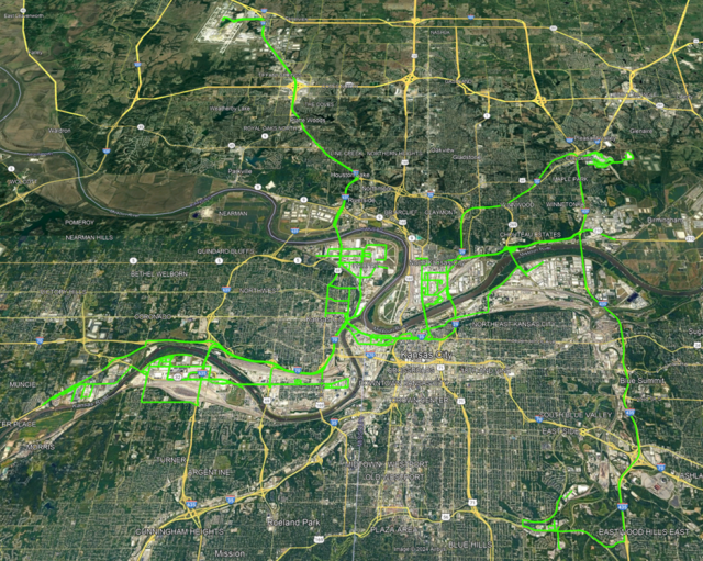
In partnership with the National Enforcement Investigation Center (NEIC), EPA Region 7 conducted a survey of several air pollutants in the Kansas City Bi-State Area. EPA identified 34 facilities that reported emissions of pollutants which could be detected by the equipment in the GMAP vehicle. EPA drove the vehicle on public roadways and access areas around the sources to conduct the monitoring.
Compliance Monitoring and Enforcement
Although the data collected by EPA in this project can only be used for screening purposes and does not indicate a permit violation, operating standard, National Ambient Air Quality Standard, or relate to a risk-based health standard, based on the GMAP survey, Region 7 did identify three facilities for follow-up compliance inspections. Those inspections were coordinated with Kansas Department of Health and Environment (KDHE) and Missouri Department of Natural Resources (MoDNR). Finalized inspection reports will be available in the “Related Documents” section below.
EPA cannot discuss potential or ongoing enforcement actions, but information on completed actions can be found on EPA’s Enforcement and Compliance History (ECHO) page. ECHO can be used to search for specific facilities in your community, analyze compliance and enforcement trends, and find settled EPA enforcement cases.
General Reporting of Air Pollution Concerns

Air pollution can be sensed by humans in many ways, most commonly through odor, sight, or physical effects. Physical and odor effects can be difficult to determine since many gases are invisible, so describing the situation in detail is vital to understanding what may be causing the emissions concern. Examples of physical effects, such as coughing, watery eyes, shortness of breath, or headaches, can be helpful when reporting a concern.
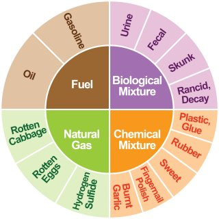
When you report an odor concern to EPA or the state, providing detailed descriptions of the odor and its duration, intensity, and location are key for the best possible follow-up investigations. The odor wheel (shown at right) can assist citizens in characterizing the smell. The following guidance explains all important information to provide when reporting odor concerns.
- What are you smelling? Use the odor wheel to help describe the odor.
- How long has the smell been happening? Hours, days, weeks, etc.
- How strong is the smell? Describe the intensity of the smell – weak, moderate, strong, or very strong.
- What is the location of the smell? Address or general area in Kansas City Bi-State Area where you experienced the odor.
- To report an air pollution complaint to KDHE, please call 785-296-1556.
- To submit an environmental concern, including odors, to MoDNR, please visit their website.
- To submit an environmental concern to EPA, please visit the ECHO page.
Additional Information Resources
- Summary of Clean Air Act
- Air Enforcement at EPA
- KDHE Air Compliance and Enforcement
- MoDNR Air Pollution Control Program
Related Documents
Geospatial Measurement of Air Pollution (GMAP)

The National Enforcement Investigation Center is the environmental forensics center for EPA’s enforcement programs.
NEIC has a mobile air monitoring vehicle, called GMAP, that is equipped with analyzers for certain pollutants – benzene, toluene, ethylbenzene, and xylene (BTEX); methane, ethylene oxide, and total volatile organic compounds (VOCs) – as well as meteorological and GPS equipment. This combination of equipment allows for real-time monitoring and mapping of pollutants while the vehicle is in motion or standing still.
The GMAP’s real-time monitoring data allows EPA to screen large geographic areas for “hot spots” and helps to identify locations that need further investigation. A hot spot is an area of higher contaminant concentrations relative to other areas of a site.

