
Water Quality Monitoring Resources for the Merrimack River
- How's My Waterway
- Water Monitoring Dashboard
- Sharing Water Quality Data with EPA's Water Quality Exchange (WQX)
- Contact Information for Merrimack River Sampling Programs
Water quality monitoring is a crucial aspect to protecting and understanding water resources. Under the Clean Water Act, state, tribal and federal agencies monitor lakes, streams, rivers and other types of water bodies to determine water quality condition. In addition, many nongovernmental watershed associations, nonprofits and academic organizations conduct their own water quality monitoring to answer locally driven questions. The data generated from these monitoring activities help water resource managers know where pollution problems exist, where to focus pollution control resources and where progress has been made.
The U.S. Environmental Protection Agency (EPA) and partners have been working to improve the ease with which organizations large and small can store their water quality monitoring data in the Water Quality Portal. Once there, data become accessible to scientists, government policy makers, and the public in a permanent archive. Below are available tools and resources that help organizations contribute, view, share and interact with data in the Portal.
How's My Waterway
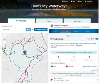
How's My Waterway provides information about the condition of local waters based on data that states, federal, tribal, local agencies and others have provided to EPA. Water quality information is displayed on 3 scales in How's My Waterway: community, state and national. More recent or more detailed water information may exist that is not yet available through EPA databases or other sources. Check out the How's My Waterway Fact Sheet.
How's My Waterway provides a data page which lists the sources of data displayed as well as where this data shows up throughout the tool. The data page can be found at the top of any page in How's My Waterway.
If you're an educator that's looking for lesson plans, webinars, and other educational materials you can consult EPA's How's My Waterway resources for educators.
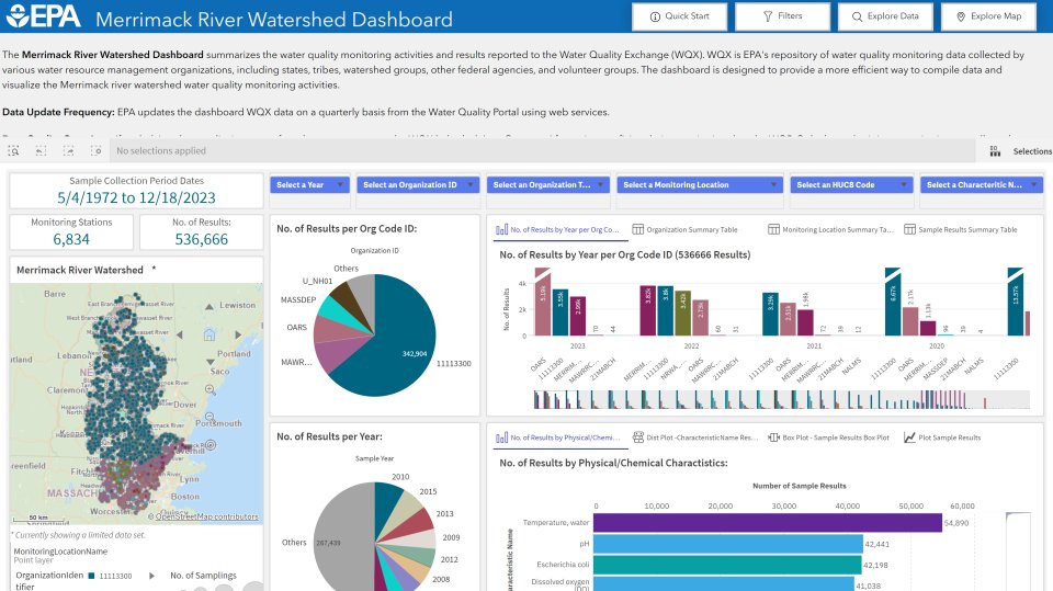
Water Monitoring Dashboard
This dashboard summarizes the water quality monitoring data from the Water Quality Portal for the Merrimack River Watershed going back to 1972. The dashboard highlights the sampling efforts in the watershed by various organizations and provides analysis capabilities that can be used to evaluate water quality conditions. Users can look at trends over time or compare sampling stations and characteristics in a variety of ways by a variety of metrics.
Source Data Description: Water Quality Portal (via Web Services)
Data Refresh Schedule: Quarterly
Audience or Use Cases: The dashboard provides increased capacity for data analysis and expand data sharing among state-level and community-based monitoring groups by providing local access to their water quality data, as well as data from other organizations to augment their own water quality data for data analysis and identifying opportunities to improve conditions. The dashboard was designed as a tool specific to state-level and local community-based monitoring group data access and analysis needs to complement the more generalize approach of the EPA's How's My Waterway.
Sharing Water Quality Data with EPA's Water Quality Exchange (WQX)
Government agencies and nonprofit environmental groups can share their data publicly through the national Water Quality Portal by submitting data to EPA's Water Quality Exchange (WQX). From the Portal, data can be integrated into a variety of viewers, data analytical tools, portals and data assessment products, like How's My Waterway, the Merrimack River Watershed Dashboard, and the WQP Tools for Automated Analysis (TADA). The result is greater data accessibility for the public and increased utility by decisionmakers. The MassBays National Estuary Partnership developed MassWateR to assist nonprofit environmental groups in preparing and submitting their data to WQX. The package and guiding materials are available on the MassBays Github site.
Contact Information for Merrimack River Sampling Programs
Nonprofit / Nongovernmental
Merrimack River Watershed Council
Nashua River Watershed Association
Souhegan River Watershed Association
Upper Merrimack Watershed Association
OARS
Mass Audubon
Groundwork Lawrence
Essex County Greenbelt
Town, State, and Federal Agencies
Merrimack Valley Planning Commission
Merrimack Valley Stormwater Collaborative
Lowell Wastewater Utility
Haverhill Wastewater Treatment Plant
Pennichuck Water Works
Greater Lawrence Sanitary District
New England Interstate Water Pollution Control Commission (NEIWPCC)
Massachusetts Dept of Environmental Protection (DEP)
Massachusetts Division of Marine Fisheries (DMF)
Massachusetts Division of Fisheries and Wildlife (DFW)
New Hampshire Department of Environmental Services
New Hampshire Fish and Game Department
US Army Corps of Engineers (ACOE)
US Geological Survey (USGS)
US Environmental Protection Agency (EPA)
NOAA Fisheries
Universities
UMass Lowell
Northern Essex Community College
Boston University