
Example - Salt Marsh
Step 1 Set Goal & Scope
Led by the Rhode Island (RI) Coastal Resources Management Council and the Town of Charlestown, the Ninigret Pond Salt Marsh Restoration and Enhancement Project included a team of local stakeholders and state and federal partners. After a series of planning meetings, ecological and social goals (Raposa et al. 2022) set by the multi-partner team were to:
-
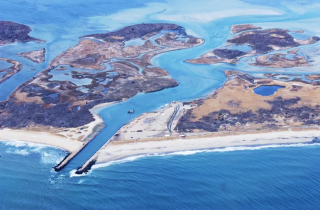
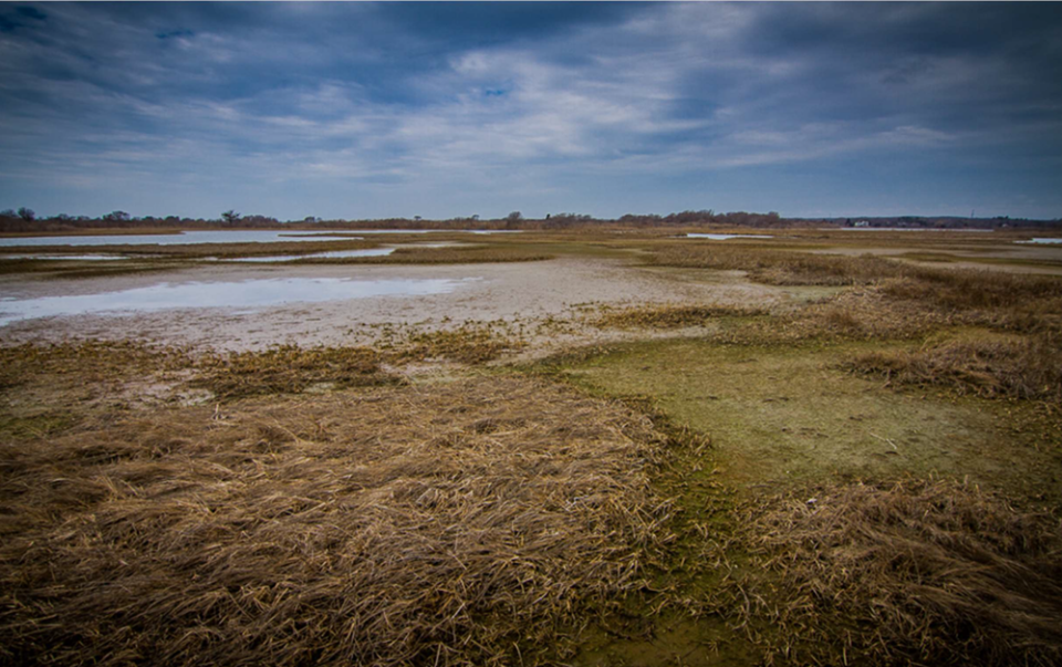
Figure 1. Areas of the Ninigret salt marsh were degrading due to prolonged surface water ponding from Sea Level Rise. Restore high marsh plant species to portions of the marsh degraded as a result of prolonged surface water ponding (Figure 1) due to sea level rise (SLR).
- Increase the resilience of the marsh to future SLR.
- Dredge and deepen the channel within the Charlestown Breachway to improve navigation for recreational boaters.
- Slow the sedimentation rate within the channel and in submerged aquatic vegetation beds within the pond through improved water circulation.

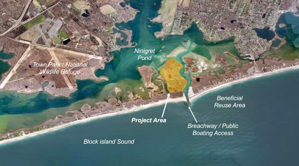
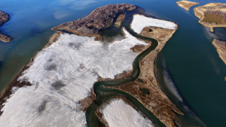
The geographic scope was set as the Ninigret Pond back-barrier salt marsh (Figure 2) adjacent to a fabricated breachway in Charlestown, RI, based on a combination of management objectives for the area and the co-located availability of a dredged material source, as well as an opportunity to combine ecological restoration goals with defined social goals of the local community.
The project incorporated an Adaptation Strategy (Wigand et al. 2017), which included specific monitoring objectives to quantify ecological effects of dredged sediment placement (i.e., beneficial re-use of dredged materials) on a "drowning" marsh by measuring key physical and biological parameters before and after sediment placement and at a nearby control marsh.
Step 1 Embracing Collaboration Best Practices
From the start, the project benefited from a prior decades-long collaboration of the team’s marsh scientists and practitioners and their engagement with communities in Rhode Island, which had already established a rich tradition of inclusiveness among partners and the public.
Engaging stakeholders: The effort began when stakeholders from the town of Charlestown reached out to the state Coastal Resources Management Council (CRMC), and together they engaged partners from non-governmental organizations (NGOs) and federal and state agencies to set a goal and scope for dredging and sediment placement for marsh restoration as an adaptation strategy.
Collaborating broadly: The Salt Ponds Coalition (a local NGO) conducted outreach across the community on project goal and scope and obtained letters of support from members of the public and local businesses.
Developing sustainable solutions and social cohesion: The project goal and scope combined the community’s two aims of dredging the salt pond to protect recreational uses and piloting an adaptation project to increase marsh sustainability and coastal resilience to sea level rise and increased storm events.
For additional guidance, see Organon Collaboration Best Practices by Step.
Step 2 Assess Threats & Vulnerabilities
The planning team documented threats to the Ninigret Pond marsh system based on evidence of prolonged flooding, inundation stress (large areas of marsh platform die-off; Figure 3), and marsh edge erosion resulting from accelerated sea level rise (SLR).
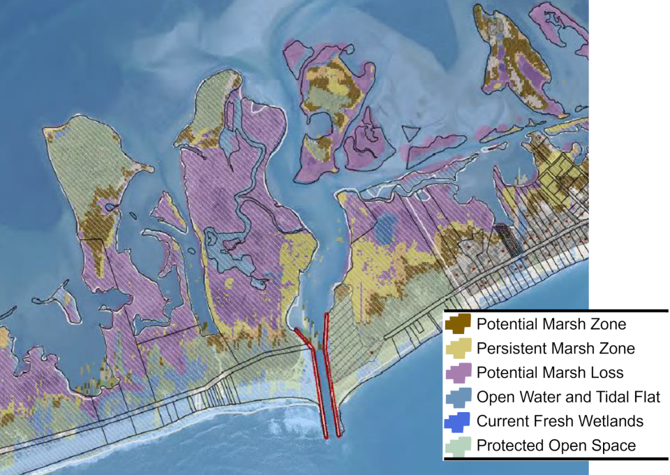
The planning team used the outputs of Sea Level Affecting Marshes Model scenarios (Figure 4), die-off areas, and total unvegetated cover to assess marsh vulnerability to SLR.
Step 2 Embracing Collaboration Best Practices
Engaging stakeholders: Partners from institutions such as the Narragansett Bay National Estuarine Research Reserve, University of Rhode Island (RI), RI Natural History Survey, Save the Bay, and the Nature Conservancy provided vulnerability information that could be shared with the community, which helped to identify sediment placement as a priority option to increase marsh elevation in the face of high rates of sea level rise.
Collaborating broadly: Town meetings with a range of participants allowed discussions of public concerns about how much dredged sediment could be accommodated by the project.
Developing sustainable solutions and social cohesion: Town meetings included presentations on the project plan that explained the vulnerabilities of the marsh, its recreational uses, and its contribution to coastal resilience; meetings also aimed to proactively anticipate and discuss public concerns and build cohesive community buy-in.
For additional guidance, see Organon Collaboration Best Practices by Step.
Step 3 Identify, Evaluate & Prioritize Site(s)
A specific identified site, the Ninigret marsh (Figure 5), was the selected focus of the project based on evaluation of the site's degraded marsh condition (see Step 2), vulnerability to sea level rise, and concern over high marsh loss (Watson et al. 2017) in the broader region. Other prioritization factors for this particular site included location adjacent to a previously permitted dredge area that could serve as a sediment source to test a relatively new adaptation methodology (sediment placement to build elevation capital) and project team knowledge of the community’s goal to maintain the previously dredged basin for recreation and navigation.
Step 3 Embracing Collaboration Best Practices
Engaging stakeholders: The Coastal Resources Management Council led the site selection process with partners (such as Narragansett Bay National Estuarine Research Reserve and Save the Bay) and the town, with all parties agreeing on the Ninigret site based on its degraded and vulnerable condition and its proximity to where dredging needed to occur and could provide a sediment source for marsh restoration.
Developing sustainable solutions and social cohesion: The site was agreed upon with the community because it supported multiple community desires: channel dredging to preserve recreational use and sediment placement for adaptive marsh restoration.
For additional guidance, see Organon Collaboration Best Practices by Step.
Step 4 Identify, Design & Select Interventions
Targeted dredged sediment placement on degraded marsh (a marsh elevation enhancement technique; Figure 6), followed by restoration of wetland grasses through plantings (Figure 7), were identified and selected as the intervention tactics that would build resilience to sea level rise (SLR) and fulfill both the ecological and community goals identified in Step 1. Restoration goals and construction/dredging considerations drove project design.

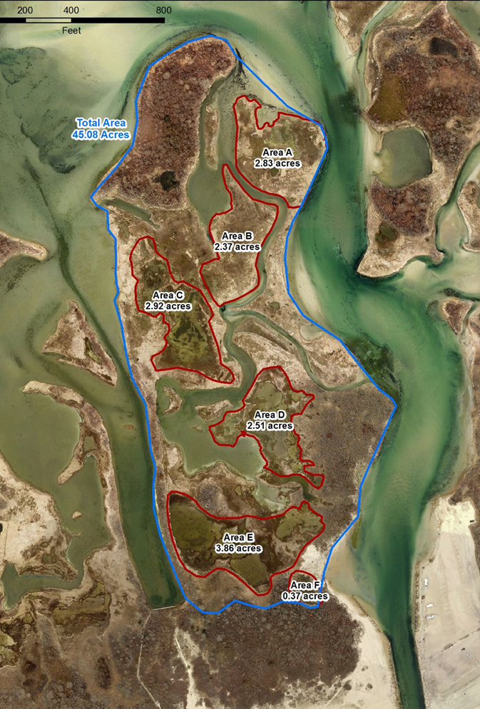
The volume of dredged sediment to place on the existing marsh platform in the project area (Figure 8) was designed to achieve maximum elevation capital while not exceeding target elevation ranges that support the growth of dominant, native high marsh plant species. Selecting the upper ranges of native plant species growth elevations as elevation targets achieved this criterion, thereby reducing future elevation maintenance costs and extending the expected life span of the restoration project. The volume of material needed to achieve target elevations was estimated based on the differences between existing and target platform elevations in degraded subareas of the marsh.

Step 4 Embracing Collaboration Best Practices
Engaging stakeholders: The project partners collaborated with local contractors to design the dredging and sediment placement method, with the collective project team and the community understanding that marsh restoration via sediment placement was a relatively novel method being tested by this experimental pilot to learn if it was an effective adaptation strategy.
Developing sustainable solutions and social cohesion: Through meetings with the Environmental Protection Agency, Army Corps of Engineers, and other researchers, the community was encouraged to weigh in on the design of the intervention and discuss long-term sustainability through community buy-in to monitor and maintain the restored marsh into the future.
For additional guidance, see Organon Collaboration Best Practices by Step.
Step 5 Assemble Objectives, Targets & Action Plan
The core planning partners reviewed the proposed project, which represents the assembled outputs from steps one through four (i.e., goals & objectives, vulnerabilities, management targets, monitoring design) and developed the components into an action plan for implementation.
Through this plan integration, roles were defined for project partners: Coastal Resources Management Council as project lead and funding applicant; Save The Bay (non-governmental organization; NGO) as the lead for maintenance and plantings; Save the Bay, Rhode Island National Estuarine Research Reserve, and U.S. Environmental Protection Agency for monitoring; the Town as the state and federal permit applicant; and the Salt Ponds Coalition (local watershed NGO) leading community outreach and support.

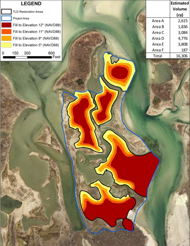
The project team developed a detailed conceptual plan in coordination with the engineering consultant through several team meetings. The primary design consideration was defining the needed volume of dredged material as a balance between fulfilling the social goal of maintaining the basin for recreation with the ecological goal of restoring marsh elevation (Figure 9) and building the resilience of the marsh system.
A major component was permitting and regulatory compliance; this was managed by the town as a project partner, aided by the engineering consultant, and involved:
- NEPA EA /Section 106 (USFWS lead federal agency)
- USACE Section 404 Permit (with sign-off by EPA and NOAA Nat. Marine Fisheries Service)
- State Section 401 Water Quality Certification
- Coastal Resources Management Council (CRMC) Assent.
Step 5 Embracing Collaboration Best Practices
Engaging stakeholders: The project partners, led by the state Coastal Resources Management Council, collaborated to submit a funding proposal (which was awarded) for an action plan; the plan specified the role of the non-governmental organization Save The Bay in coordinating the participation of community volunteers in maintenance and plantings, and the Salt Ponds Coalition in leading outreach to keep the community apprised of project progress and milestones.
For additional guidance, see Organon Collaboration Best Practices by Step.
Step 6 Implement Interventions & Monitoring
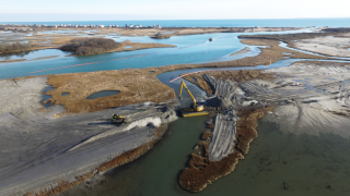
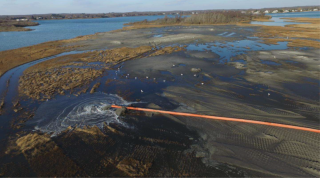
For implementation of the dredged sediment placement intervention (Figure 10), the Coastal Resources Management Council led construction oversight and reported information about project schedule and progress to the planning team as construction proceeded. Implementation progress was also monitored by knowledgeable stakeholders (town representatives).
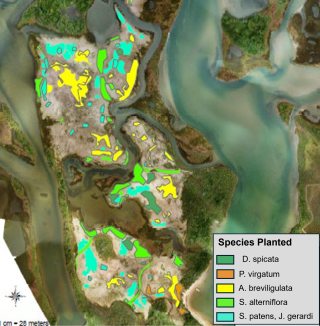
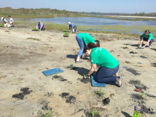
Following the sediment placement, the marsh planting phase (Figure 11) was primarily carried out by volunteers coordinated by the non-governmental organization project partner (Save the Bay), during which corrections were made to site grades and drainage.
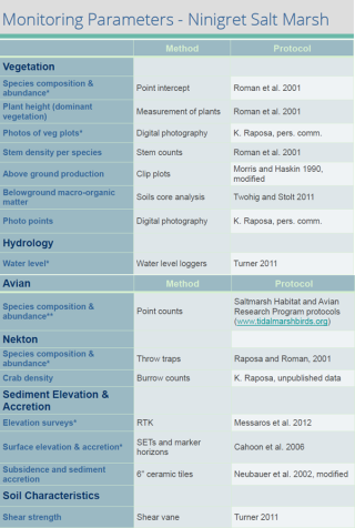
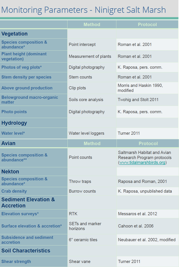
The project planning team developed a comprehensive monitoring plan to evaluate effectiveness of the sediment placement technique, as reflected in hydrological, geophysical, and biological responses. Parameters monitored included inundation patterns, elevation, salinity, soils, vegetation, nekton, and birds (Figure 12). A BACI (Before/After/Control/Impact) design was established, using a control site at a nearby National Wildlife Refuge, so that monitoring would be done before and after project implementation at both the control and impact (i.e., restoration) sites.
Project implementation included placement of 26,000 cubic meters of dredged material (Figure 13) and the restoration of ~20 acres of marsh, at a total cost of about $1.6 million (for design, engineering, permitting, and construction/ dredging). Note, however, that there was no formal monitoring of social indicators for this project. Due to the lead project team members' limited capacity, inclusion of stakeholders and partners in planning (steps 1-4) and implementation (steps 5, 6) was essential to enabling projects of greater scope and scale.
Step 6 Embracing Collaboration Best Practices
Engaging stakeholders: Because the project was piloting a novel technique, stakeholders from across state, federal and non-governmental partner organizations collaboratively incorporated monitoring plans from the onset to assess how well the restoration increased elevation and maintained marsh habitat.
Collaborating broadly: The state Coastal Resources Management Council and other partners kept the community broadly informed of project implementation in local newspaper articles and provided boat visits to all interested community members to view the marsh site after sediment placement.
Developing sustainable solutions and social cohesion: Marsh planting was coordinated by Save the Bay (a local non-governmental organization) with participation from numerous community volunteers who planted thousands of marsh plants at the site; this enhanced social cohesion through capacity building of community volunteers to help with implementation and take ownership of long-term marsh maintenance for sustainability.
For additional guidance, see Organon Collaboration Best Practices by Step.
Step 7 Document Progress & Evaluate Success
Documentation of pre- and post-sediment placement monitoring data, compared between the restoration site and a control site, enabled project progress and success evaluation .
Key findings (Figure 14):
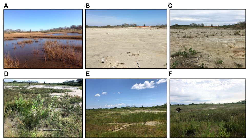
- Sediment placement at the Ninigret site during the winter of 2016 changed the landscape from a waterlogged marsh with stressed vegetation and expansive surface ponding to one dominated by sand flats.
- Marsh vegetation recovered rapidly to initial levels after sediment placement via natural colonization and plantings.
- By the third growing season after sediment placement (2019), much of the impact site had re-vegetated sparsely, and by 2020, most areas were vegetated with very little exposed sand.
- Sediment placement effectively raised marsh surface levels and increased elevation capital relative to water levels, with enhanced elevations appearing stable after three years.
Monitoring results not only informed the evaluation of project success and potential adaptive management activities needed, but also provided lessons learned that could be applied to future marsh restoration/adaptation interventions using dredged sediment placement. As a result, the Ninigret project led to a follow-on project at nearby Quonchontaug Salt Pond.
Examples of valuable monitoring results included improved information on:
- Factors relevant to decisions on placed sediment thickness include sediment type, tide range, existing marsh elevation and plant distributions, as well as project goals and desired lifespan of the new marsh.
- Considerations for determining final marsh platform elevation targets that maximize elevation capital within the range of native plant target growth elevations but stay below elevations conducive to invasive species such as Phragmites (noting that adaptive management to control invasion by undesirable exotics may be necessary after sediment placement).
- Rate/success of revegetation on thick versus thin layer sediment placement (e.g., evidence that a marsh can largely revegetate a few years after large-scale addition of thick (30cm+) sandy dredge sediment, with no apparent adverse effects on marsh use by fish or birds).
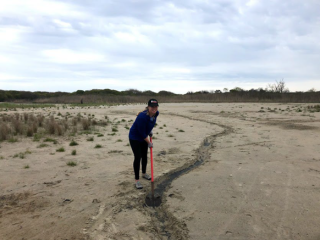
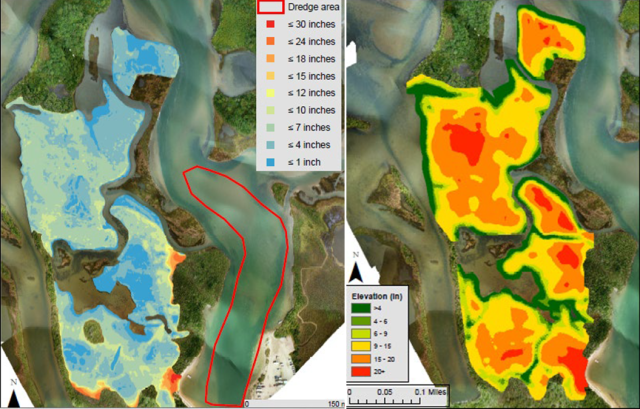
Adaptive management activities (Figure 15) during approximately two years following sediment placement were informed by marsh-scale salinity mapping that identified areas of high salinity and where freshwater inputs were located and included adjustments to elevations and marsh hydrology (e.g., excavation of runnels) to drain surface water and discourage colonization of invasive Phragmites australis, as well as additional planting of native marsh plants and continued treatment and removal of Phragmites.
Step 7 Embracing Collaboration Best Practices
Engaging stakeholders: Through outreach led by the Salt Ponds Coalition (a local non-governmental organization), the community learned of the success of the project based on monitoring results from before, during and after the intervention; this led to approval by the town of a follow-up marsh sediment placement project in another location.
Collaborating broadly: When the community was informed about project success and lessons learned and discussed the value of follow-on work at another site using the same methods, meetings were designed to include a range of members of the public.
Developing sustainable solutions and social cohesion: To support sustainability of the restored marsh, community partners have been identified for follow-up monitoring in the longer term, with recognition that this pilot is not only about restoring Ninigret marsh, but also about achieving learning that can be applied in more places; and the project team is developing a set of criteria for social goals to complement biophysical goals in the follow- project that is being initiated next.
For additional guidance, see Organon Collaboration Best Practices by Step.