Cyanobacteria Assessment Network (CyAN)
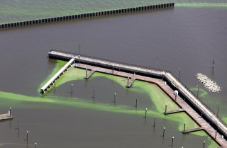
CyAN is a multi-agency project to develop an early warning indicator system to detect algal blooms in U.S. freshwater systems. This research supports federal, state, tribal, and local partners in their monitoring efforts to assess water quality to protect aquatic and human health.
Project Overview
The mission of the CyAN project is to support the environmental management and public use of U.S. lakes and estuaries by providing a useful and accessible approach to detecting and quantifying algal blooms and related water quality using satellite data records.
Goals
- Develop a uniform and systematic approach for identifying cyanobacteria blooms across the contiguous U.S. using ocean satellites.
- Create a strategy for evaluation and refinement of algorithms across satellite platforms.
- Identify landscape linkage postulated causes of cyanobacterial blooms in freshwater systems.
- Characterize exposure and human health effects using ocean color satellites in drinking water sources and recreational waters.
- Characterize responses and economic value of an early warning system using ocean satellites and a mobile dissemination platform.
- Disseminate satellite data through multiple public interfaces including (1) a mobile and web-base application, (2) EnviroAtlas, (3) Report on the Environment, and (4) NASA's Ocean Color Web.
Outcomes
- Created a standard and uniform approach for early identification of cyanobacterial blooms that is useful and accessible to stakeholders of freshwater systems using the Ocean Land Colour Instrument (OLCI) on Sentinel-3.
- Develop an information dissemination system for expedient public health advisory postings.
- Connected cyanobacterial events with health, economic, and environmental conditions.
Project Timeline
The CyAN project officially started October 1, 2015. It provided continental U.S. coverage using the Envisat MERIS archive from 2002-2012 in Fiscal Year 2017. Daily and weekly coverage using the Sentinel-3 OLCI sensor are now publicly available from 2016 to current day. The Landsat surface water temperature product is now publicly available through USGS EROS. The original project concludes in 2023 and will transition to applying higher resolution Sentinel-2 Multi-Spectral Imager data in 2024. While the Sentinel-3 portion of the project will conclude, the data will continue to be made publicly available and reprocessed annually.
Questions and Agency Leads
Comments or Questions
Contact us about the CyAN Project
Agency Leads
- Blake Schaeffer, EPA
- Bridget Seegers, NASA
- Richard Stumpf, NOAA
- Keith Loftin, USGS
- Tyler King, USGS (CyAN Sentinel-2)
- Molly Reif, USACE (CyAN Sentinel-2)
Publications and Other Resources
Journal Articles
2023
- Identifying lakes at risk of toxic cyanobacterial blooms using satellite imagery and field surveys across the United States
- Satellite and in situ cyanobacteria monitoring: understanding the impact of monitoring frequency on management decisions
2022
- Property values and cyanobacterial algal blooms: evidence from satellite monitoring
- Paths to research-driven decision making in the realms of environment and water
- Satellites quantify the spatial extent of cyanobacterial blooms across the United States at multiple scales
- A validation of satellite derived cyanobacteria detections with state reported events and recreation advisories across U.S. lakes
- Satellite-derived cyanobacteria frequency and magnitude in headwaters and near-dam reservoir surface waters of the Southern U.S.
2021
- The MERIS time series and application for chlorophyll-a
- Planning monitoring programmes for cyanobacteria and cyanotoxins
- Assessing cyanobacterial frequency and abundance at surface waters near drinking water intakes across the United States
- Satellite remote sensing to assess cyanobacterial bloom frequency across the United States at multiple spatial scales
- Acute health effects associated with satellite-determined cyanobacterial blooms in a drinking water source in Massachusetts
2020
- Quantifying the Human Health Benefits of Using Satellite Information to Detect Cyanobacterial Harmful Algal Blooms and Manage Recreational Advisories in US Lakes
- Exploring the potential value of satellite remote sensing to monitor chlorophyll-a for US lakes and reservoirs
- Evaluation of a satellite-based cyanobacteria bloom detection algorithm using field-measured Microcystin data
- Quantifying national and regional cyanobacterial occurrence in US lakes using satellite remote sensing
- Satellite resolvable estuaries within the continental United States
- Envisat MERIS and Sentinel-3 OLCI Satellite lake water quality flags for the contiguous United States
2019
- Satellite detected cyanobacteria in large U.S. lakes on your Android phone
- Ocean Colour: current status and future perspective
- Measurement of cyanobacterial bloom magnitude using satellite remote sensing
2018
- Towards a satellite-based monitoring system for water quality
- Extending century-long monitoring of global water clarity to the future
- Mobile device application for monitoring cyanobacteria HABs using Sentinel-3 satellite Ocean and Land Colour Instruments
- Evaluation of RapidEye data for mapping algal blooms in inland waters
- An initial validation of Landsat 5 and 7 derived surface water temperature for U.S. lakes, reservoirs, and estuaries
- Performance metrics for the assessment of satellite data products: an ocean color case study
- Monitoring algal blooms in drinking water reservoirs using the Landsat-8 Operational Land Imager
2017
- Satellite monitoring of cyanobacterial HAB frequency in recreational waters and drinking source waters with satellites
- A method for examining temporal changes in cyanobacteria HAB spatial extent using satellite remote sensing
2016
- Challenges for mapping cyanotoxin patterns from remote sensing of cyanobacteria
- Forecasting annual cyanobacterial bloom biomass to inform management decisions in Lake Erie
- Evaluation of time-series smoothing algorithms for land-cover classifications using MODIS-NDVI multi-temporal data
2015
- Evaluation of cyanobacteria cell count detection derived from MERIS imagery across the eastern USA
- A satellite perspective to monitor water quality using your mobile phone
- Agencies collaborate, develop a Cyanobacteria Assessment Network (CyAN)


