
About SEA Tool
About the Tool
This page provides additional information on the tool, intended audience, benefits of using SEA Tool, and source data.
Who Should Use the Tool
The primary audiences for the SEA Tool are adaptation specialists and practitioners, GIS users, and organizations and individuals conducting vulnerability assessments. These include federal and state agencies, climate change researchers, industry, and others. The tool is designed for a broader audience to obtain sea level rise information quickly and easily.
Benefits of Using the Tool
Sea level rise models provide valuable data for coastal planning, infrastructure development, and risk management. By predicting potential impacts, SEA Tool can help adaptation practitioners implement effective strategies to mitigate damage, protect ecosystems, and ensure public safety.
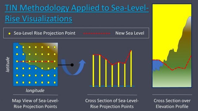
The SEA Tool represents an important advancement in the ability to estimate potential effects of sea level rise, with more flexibility and ease of use. The user-friendly nature of the tool provides clear and specific data for varied sea level rise scenarios. These important materials help to ensure that users can access and easily use the tool, design scenarios which are most relevant for them, and use outputs accurately and effectively.
Options to Explore Sea-Level-Rise Projections
There are two ways to explore the sea-level-rise projections.
Option 1: Explore by Critical Elevation
Allows the user to examine the data with respect to the “critical elevation” of a site. Historical tidal and storm surge data have been integrated into SEA Tool, allowing the user to assess cumulative still water height above mean sea level resulting from the interaction of tidal variation, storm surge and sea-level rise. The user will gain an understanding of how sea level may change through time and when it may intersect with the site’s critical elevation.
Option 2: Explore GIS Data by Year
A mapping tool allows users to explore data from the NOAA report as a series of GIS layers to address questions such as: 1) Which areas of the U.S. and its territories will be impacted by sea-level rise? and 2) How deep will the water be? Additionally, statistics are provided to describe the difference between regional and global sea-level projections as well as assess the likelihood of each visualization based on the probability associated with a range of possible future greenhouse gas emissions.
Source Data
In February 2022, The Sea Level Rise and Coastal Flood Hazard Scenarios and Tools Interagency Task Force produced a report entitled “Global and Regional Sea Level Rise Scenarios for the United States.” The report and its associated data table were intended to update scenarios of global mean sea-level rise and integrate the global scenarios with regional factors contributing to sea-level change for the entire U.S. coastline. The Interagency Task Force report incorporates these regionally appropriate scenarios within coastal risk management tools and capabilities deployed by individual agencies in support of the needs of specific stakeholder groups and user communities.
Data Sources and Publications
- 2022 Global and Regional Sea Level Rise Scenarios for the United States: Updated Mean Projections and Extreme Water Level Probabilities Along U.S. Coastlines (PDF)
- Application Guide for the 2022 Sea Level Rise Technical Report (PDF)
- 2022 Sea Level Rise Technical Report Data Files (ZIP)
- USGS The National Map – Elevation Products (3DEP)