
Lake Erie Water Quality Data
On this page:
- Overall Conditions
- Phosphorus Loads
- Harmful Algal blooms
- Hypoxia
- Nuisance benthic algae
- Data and Reports
Overall Conditions
Phosphorus loads to Lake Erie and the in-lake response of harmful algal blooms and hypoxia are tracked annually, and evaluated every 5 years. High phosphorus and chlorophyll concentrations and harmful algal blooms indicate that the western basin of Lake Erie is highly eutrophic. Phosphorus and chlorophyll concentrations in the central and eastern basins are relatively stable and consistent with the desired ranges. However, total phosphorus concentrations are stable in the Maumee River watershed and dissolved reactive phosphorus may be declining. This is important because phosphorus from the Maumee River is the key driver of the western basin HAB.
As of 2021, there is no evidence of a declining trend in phosphorus loads on a lakewide or basin-scale. However, total phosphorus concentrations are stable in the Maumee River watershed and dissolved reactive phosphorus may be declining.
Phosphorus Loads
EPA and ECCC work together to calculate Total Phosphorus (TP) loads to Lake Erie on an annual basis. The loads are calculated using available data and statistical models to estimate the phosphorus contribution from a variety of sources.
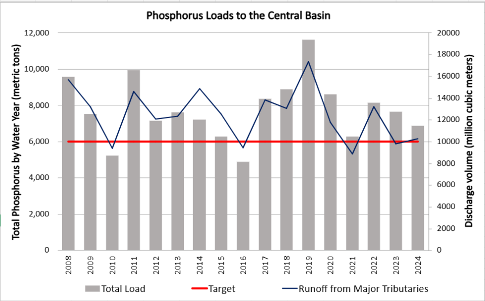
As of 2024, phosphorus load targets are mostly not being met and load reduction trends are difficult to discern. Phosphorus loads continue to be largely driven by tributary discharge volume, which is highly variable from year-to-year. The target of 6,000 metric tons annually (MTA) was only met once from 2013 - 2024(in 2016, a notably dry year).
Table of Annual Phosphorus Loads from 2008 - 2024
U.S. Priority Tributaries
There are a total of 10 U.S. tributaries to Lake Erie with a phosphorus reduction target. The most critical of these is the Maumee River, which drains a total of 6,568 square miles and over 4 million acres of cropland in Ohio, Michigan, and Indiana.
Soluble phosphorus loads delivered from the Maumee River during the spring is the best predictor of harmful algal bloom severity each summer.
View data on the Priority Tributaries.
Harmful Algal Blooms
Blooms with the potential to harm human health or aquatic ecosystems are referred to as harmful algal blooms. In freshwater systems, cyanobacteria (or blue-green algae) are microorganisms that can produce HABs. The phosphorus reduction targets are expected to reduce the amount of cyanobacteria biomass in the lake to less than 9,600 metric tons (MT) in 9 years out of 10. This metric assumes that minimizing biomass reduces the potential for high toxin production.
Lake Erie Bloom Severity, 2002-2024

The Lake Erie Severity Index (SI) is derived from NOAA’s National Centers for Coastal Ocean Science HAB Monitoring Program.
Cyanobacteria biomass is measured over the growing season using remote sensing validated with water samples taken in the field. The desired threshold not to exceed 9,600 MT corresponds to a target SI of 2.9. An SI above 5 is considered a “severe” bloom, while blooms over 7 are “very severe.”
Overall, there is high interannual variability in the severity of the bloom. Between 2017 to 2024, the bloom SI target was met in 2018, 2020, and 2023. The largest blooms to date have occurred in 2011 and 2015. Blooms from 2021-2024 were generally perceived as less intense with fewer “scum” events as compared to 2008-2010 and 2014. In 2024, the severity index was 3.9, which is considered “moderate.”
View the current status of the bloom: Lake Erie Hab Forecast
NOAA updated the HABs Severity Index time series record for 2002-2024 in May 2025. Read Frequently Asked Questions (pdf) (770 KB) about this change.
Hypoxia
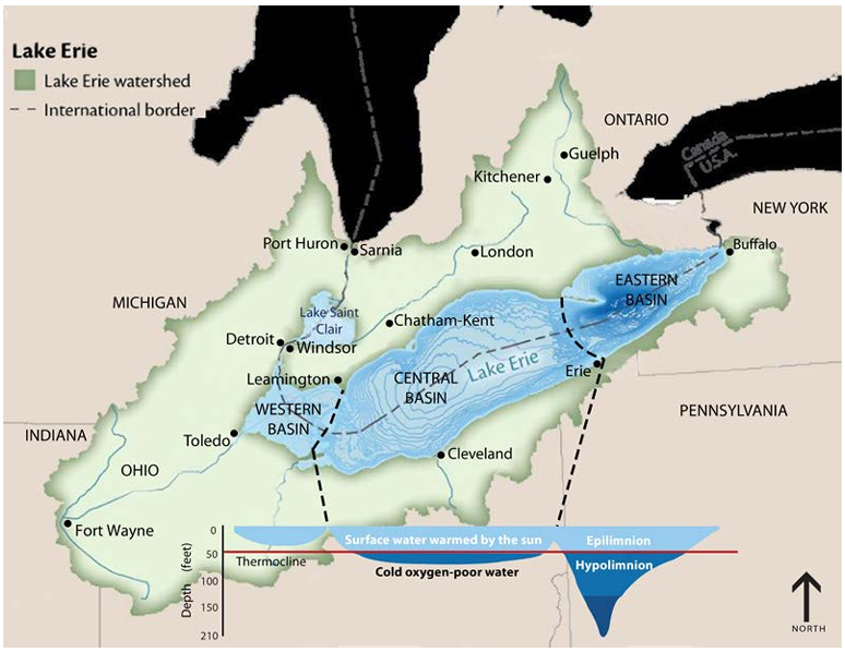
The central basin of Lake Erie has an average depth of 18.3 meters (60 feet) and a maximum depth of 25 meters (82 feet). Excess phosphorus contributes to hypoxic (low-oxygen) conditions in the cold bottom layer of the lake (the hypolimnion) when algae die and decompose. This decomposition uses up the oxygen during the summer, leaving little to none for the aquatic community which suffocates or moves elsewhere, creating Lake Erie’s “Dead Zone.”
Concentrations of dissolved oxygen in the central basin of Lake Erie exhibit high interannual variability. Between 2018 and 2023, EPA conducted dissolved oxygen surveys annually at 10 stations within Lake Erie’s central basin. During this time period, every station, except one during 2018, experienced hypoxic conditions (2 mg/L), and most reached anoxic conditions (<1.0 mg/L), between August and October of each year. Lake Erie Dissolved Oxygen annual reports are available online: Lake Erie Technical Reports
Nuisance Benthic Algae
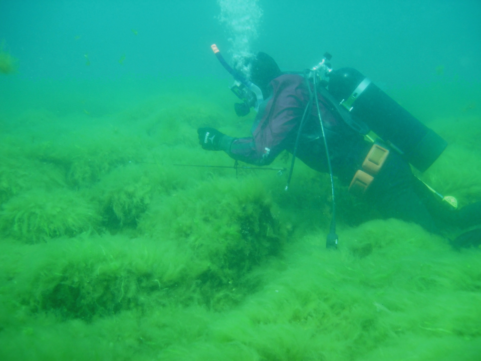
Cladophora and benthic algae can grow to nuisance levels in Lake Erie’s eastern basin. Cladophora is a type of stringy (filamentous) algae that grows on hard surfaces underwater. Cladophora is a type of stringy algae that grows on rocks, wood, logs, and other hard surfaces underwater. Cladophora grows rapidly during the warm summer months, detaches, and becomes free-floating mats which can eventually become stranded on beaches.
USGS scientists are collaborating with other researchers to examine the influence of nutrient concentrations and invasive mussels on Cladophora growth. Field data collected by USGS scientists and divers is used to populate models that can help to develop Cladophora management strategies. This broad-scale, logistically complex effort is made possible with the help of multiple agency partners, including EPA, ECCC, and state agencies.