
Superfund Sites in Reuse in Colorado
If you are having trouble viewing the map in your browser, click the 'View larger map' link below
ASARCO, INC. (GLOBE PLANT)
The ASARCO, Inc. (Globe Plant) site is in Globeville, an industrial, commercial and residential area near the South Platte River in Denver, Colorado. Metal and refining operations took place on-site from 1886 to 2006. They contaminated soil, sediment, groundwater and surface water with metals and other chemicals. In 1974, the Colorado Department of Public Health and the Environment collected water and sediment samples directly west of the site and detected elevated concentrations of cadmium, arsenic, lead, zinc, and other metals. EPA proposed adding the site to the National Priorities List (NPL) in 1993. EPA removed it from NPL listing consideration in 2014. Site cleanup took place under a series of agreements between the state of Colorado and ASARCO Inc. Cleanup involved excavating and covering contaminated soil and sediment, installing a multi-layer cap, and collecting and treating contaminated groundwater, and monitored natural attenuation of an off-site contaminated groundwater plume. Crossroads Commerce Park opened on-site in 2016. It hosts warehousing, distribution and light industrial businesses. The facility provides about a million square feet of space. Wildlife habitat and recreation areas associated with the Heron Pond Natural Area are on another part of the site. A Colorado National Guard recruiting center is south of Heron Pond. Two community recreation centers are also on-site. Commercial and residential areas, a fire station, schools and parks are on the part of the site where soil cleanup took place.
Last updated October 2025
As of December 2025, EPA had data on 305 on-site businesses. These businesses employed 3,861 people and generated an estimated $1,180,432,602 in annual sales revenue. For additional information click here.
For more information:
BONITA PEAK MINING DISTRICT
The Bonita Peak Mining District Superfund site is in San Juan County, Colorado. It includes 48 mining-related source areas in a 140-square-mile area. There are over 400 abandoned or inactive mines at the site. Heavy metals from past mining activity negatively affected the land and water-based ecosystems of the three primary drainages at the site: Mineral Creek, Cement Creek and the Upper Animas River. The drainages reach a confluence at the Animas River, near the town of Silverton. The Animas River flows south from Silverton toward Durango and is used for drinking water, recreation and agriculture. Mining of silver and other base metals took place from the 1870s to 1991. EPA and the state of Colorado began investigating the area in the 1990s. Sunnyside Gold Corporation was the last mining operator at the site. From 1991 to 2015, EPA, Sunnyside Gold Corporation, the state of Colorado and the U.S. Bureau of Land Management led or oversaw reclamation and cleanup activities in the Upper Animas watershed. EPA runs an interim water treatment plant in Gladstone, Colorado, to treat water from the Gold King Mine. EPA added the site to the National Priorities List in 2016. Investigations are ongoing. EPA is reviewing possible cleanup approaches. The U.S. Bureau of Land Management and the U.S. Forest Service manage parts of the site. Tourism, retail and recreation are key industries in the area. There are a range of year-round recreational activities within the site area, including an advanced-terrain ski area, all-terrain vehicle use on high alpine roads, and many hiking trails and mountain biking trails, with more planned in the future. Beginning in 2025, EPA’s Superfund Redevelopment Program is providing technical assistance to support San Juan County consider future use options at properties they own within the site. The outcome will be a reuse assessment that explores a range of options for the tailing ponds near Mayflower Mill to ensure future use is well aligned with EPA’s cleanup decisions.
Last updated October 2025
As of December 2025, EPA did not have economic data related to on-site businesses, or economic data were not applicable due to site use. For additional information click here.
For more information:
BRODERICK WOOD PRODUCTS
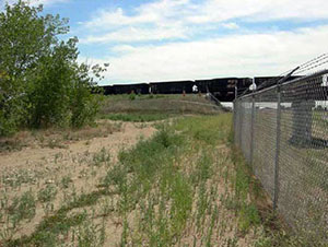
The 64-acre Broderick Wood Products Superfund site is north of Denver, Colorado, in unincorporated Adams County. Broderick Wood Products ran a wood-treating facility on-site from 1947 to 1982. BWP treated power poles, fence posts, railroad ties and other wood products on the property. Operators put hazardous wastes from the process in two unlined holding areas. Sampling found contamination in groundwater, soil and sludge. EPA added the site to the National Priorities List in 1984. Broderick Investment Company, the potentially responsible party, did most of the cleanup from 1989 to 1994. The long-term remedy involves more cleanup of chemicals in soils, sediments, groundwater, buildings and their contents. In 2003 and 2004, Union Pacific Railroad worked with EPA, the state and BIC on a rail line embankment crossing the site. The project was part of a larger effort to improve rail service and reduce rail congestion in the Denver area. As part of the project, parties made improvements to site cleanup systems. In 2005, BIC put in an access road at the site’s northern boundary. This road was a primary access point and helped facilitate redevelopment. In 2007, BIC sold most of the site property to Scott Contracting. Brannan Sand & Gravel acquired the property in 2013. It now runs an asphalt plant on-site. BIC sold another part of the site property in 2019. This area is now in use for parking and materials storage.
Last updated October 2025
As of December 2025, EPA had data on 2 on-site businesses. These businesses employed 23 people and generated an estimated $4,054,000 in annual sales revenue. For additional information click here.
For more information:
CALIFORNIA GULCH
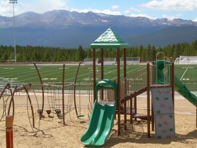
The 18-square-mile California Gulch Superfund site is in Lake County, Colorado. It includes the city of Leadville and the surrounding area. Starting in 1857, prospectors and companies mined the area extensively for heavy metals. Mining operations left mining byproducts on-site. These materials contain heavy metals that contaminated native soils and waterways, such as the Arkansas River. EPA added the site to the National Priorities List in 1983. Cleanup actions across over 80% of the site, including the city of Leadville, are complete. EPA took those areas off the NPL. Over the years, EPA has collaborated with the state, the community and the site’s potentially responsible parties to coordinate the continued use of the site for residential, federal, commercial and industrial purposes, as well as redevelopment and ecological restoration work. In 1998, EPA and the state signed agreements to provide public access to open space near the Arkansas River. State and local governments bought more than 2,300 acres of ranch land that serve as wildlife habitat and recreation resources. The community has incorporated the reuse of mining byproducts into the design of the Mineral Belt Trail, which opened in 2000. This nationally recognized recreation trail is built around the city along a railroad grade, which weaves through the historic mining district, highlighting the community’s history and heritage. Pilot funding from EPA’s Superfund Redevelopment Program in 2001 and 2002 provided support for the city to develop reuse plans for the site and coordinate with EPA on their implementation. Another recreational reuse at the site is the Arkansas River Trail, a 5-mile loop along the Upper Arkansas River. Leadville’s extensive recreation opportunities and 10,000-foot elevation attract endurance athletes for various events. A community-driven initiative called the Huck Finn Park Project upgraded Leadville Park into a skateboard park along with new ice-skating facilities. These facilities include a warming hut, restrooms, concessions and park equipment storage. The $1.5 million Lake County Community Park and Sports Complex opened on-site in 2009. It includes a synthetic turf athletic field built on a former zinc smelter. One of EPA’s national partners, the United States Soccer Foundation, awarded a $10,000 grant to develop initial plans for the field. Community support also led to the creation of a 21,000-square-foot concrete skate park that opened in 2013. After decades of cleanup that benefited the watershed's ecology, Colorado Parks and Wildlife honored the site with a Gold Medal Waters designation in 2014. The designation highlights the Upper Arkansas River’s improved water quality and revitalized habitat for trout and other wildlife. Also in 2014, EPA’s Region 8 celebrated the site with its Excellence in Site Reuse award, recognizing several parties for their leadership and sustained involvement with key reuse projects. A mixed-use development at the Old Rail Yard and a county judicial center are underway. Plans for the Old Rail Yard development include retail areas and homes. In January 2024, EPA issued updated lead guidance that lowered the residential screening level for lead at Superfund sites. The residential soil operable unit was deleted from the National Priorities List in 2011 as cleanup in residential areas was complete. The selected remedy for residential areas created the Lake County Community Health Plan (LCCHP) which serves as the institutional control for the residential soil operable unit. For several decades, the LCCHP has provided free services to reduce exposure to lead. These services include outreach within the community, education on how to prevent exposure to multiple potential sources of lead, testing for lead in blood, consultation and monitoring when a blood-lead level is elevated, and, if warranted, remediation of sources of lead in residential properties. The LCCHP continues to effectively protect human health and these public services will continue. The next five-year review in 2027 will consider the new guidance on screening levels for lead in soil.
Last updated October 2025
As of December 2025, EPA had data on 181 on-site businesses. These businesses employed 978 people and generated an estimated $98,128,236 in annual sales revenue. For additional information click here.
For more information:
- Recreational and Ecological Use at Superfund Sites Story Map
- Recreation and Tourism Reuse and the Benefit to Community: California Gulch Superfund Site (PDF)
- EPA Region 8 Excellence in Site Reuse Award
- Superfund Site Profile Page
Video: Making a Difference in Communities: California Gulch Superfund Site, Leadville, Colorado
Video: California Gulch: From Metals to Medals
Video: California Gulch: Revitalizing the Future of a Mining Mega Site
CAPTAIN JACK MILL
The Captain Jack Mill Superfund site is about 1.5 miles south of Ward, in Boulder County, Colorado. The site is in the headwaters of upper Left Hand Creek, in a narrow valley called California Gulch. Mining for gold and silver in the region began in 1860 and ended in 1992. These mining operations contaminated soil and surface water. EPA added the site to the National Priorities List in 2003. Cleanup activities included consolidating and capping surface waste and containing and treating contaminated water in the mine tunnel system. The site is in continued residential, recreational and ecological use. The site is also in the Arapaho National Forest and Roosevelt National Forest. The county bought property near Dew Drop and has implemented an environmental covenant to protect the remedy.
Last updated October 2025
As of December 2025, EPA did not have economic data related to on-site businesses, or economic data were not applicable due to site use. For additional information click here.
For more information:
CENTRAL CITY, CLEAR CREEK
The 400-square-mile Central City, Clear Creek Superfund site includes the former mining towns of Central City, Georgetown, Empire, Idaho Springs, Silver Plume, Empire and Black Hawk, Colorado. For almost a century, vast deposits of gold and silver ores in the area supported a profitable mining industry. In the early 1900s, business in Central City and Black Hawk declined dramatically. This left the towns with a weakened economy and deteriorating infrastructure. The mining industry also left behind waste rock and mine tailings that contaminated the Clear Creek watershed. EPA added the site to the National Priorities List in 1983. In partnership with the state, EPA did cleanup in stages. After Colorado amended state laws to allow gaming in former mining towns, parties worked with developers to clean up areas of the two towns to support casinos, hotels and restaurants. As parties developed the former mining property, they led cleanup actions. In 2009, EPA made more cleanup funding available. These resources supported capping more mine waste piles, putting sediment and drainage controls in place and treating water to restore Clear Creek. Cleanup goals include the protection of the Clear Creek watershed. In 2022, EPA added a new area of focus for the site, evaluating potential exposures to heavy metals, primarily lead and arsenic, from mine waste piles in residential areas. Cleanup is ongoing. The watershed provides water for agriculture and local drinking water supplies, as well as a wide range of recreation opportunities, including rafting, kayaking and fishing. Today, limited mining takes place on some parts of the site. The Central City Business Improvement District built Central City Parkway to facilitate access to businesses and homes. The historic Argo gold mill on-site hosts tours and serves as a tourism attraction. In July of 2024, the mill broke ground on a new gondola attraction. The gondola will take visitors up 1,300 feet to enjoy scenic views and provide access to more than 500 acres of hiking trails.
Last updated October 2025
As of December 2025, EPA had data on one on-site business. This business employed 4 people and generated an estimated $141,230 in annual sales revenue. For additional information click here.
For more information:
CHEMICAL SALES CO.
The 5-square-mile Chemical Sales Co. Superfund site is in Denver, Colorado. From 1962 to 1976, a product warehouse and a commercial and industrial chemical distribution facility were on-site. Activities led to the contamination of soil and groundwater. EPA added the site to the National Priorities List in 1990. Cleanup activities included the removal of leaking and corroded drums, construction of a water treatment plant and connection of over 400 homes to the public water supply. Operation and maintenance activities are ongoing. Continued ecological and recreational uses at the site include Sand Creek, the Sand Creek Regional Greenway trail and parks. There are also several neighborhoods and industrial and commercial areas on-site.
Last updated October 2025
As of December 2025, EPA had data on 60 on-site businesses. These businesses employed 743 people and generated an estimated $215,889,027 in annual sales revenue. For additional information click here.
For more information:
COLORADO SMELTER
The Colorado Smelter Superfund site is located in Pueblo, Colorado. A silver and lead smelter was on-site from 1883 to 1908 and contributed to site contamination. The Colorado Department of Public Health and Environment found elevated lead and arsenic in soils in 2011. EPA added the site to the National Priorities List in 2014. Cleanup activities include indoor dust removal and excavation, disposal, and replacement of contaminated soil at residential properties. Soil cleanups under the 2017 i-ROD were completed in 2023 and dust cleanups under the 2017 i-ROD were completed in 2024. Sampling and cleanup at commercial properties are ongoing. Residential properties, commercial businesses, schools, parks and other facilities on-site remain in continued use. The site’s ecological resources include the Arkansas River and Runyon Lake. In 2018, EPA’s Superfund Redevelopment Program facilitated a community visioning session that resulted in a revitalization plan for the neighborhood, which the city of Pueblo adopted. Also in 2018, together with NeighborWorks of Southern Colorado, EPA supported a Superfund Job Training Initiative program at the site. Fifteen people graduated from the program, equipped with technical skills and specialized training to work on a broad range of construction projects, including Superfund cleanups. A reuse assessment, an additional project supported by EPA’s Superfund Redevelopment Program, was completed for the site in 2024.
Last updated October 2025
As of December 2025, EPA had data on 7 on-site businesses. These businesses employed 51 people and generated an estimated $25,279,088 in annual sales revenue. For additional information click here.
For more information:
- Reducing Lending Challenges During Residential Cleanups: The Colorado Smelter Superfund Site Case Study (PDF)
- Superfund Site Profile Page
DENVER RADIUM SITE
The Denver Radium Site Superfund site consists of over 65 properties along the South Platte River Valley in Colorado. In the early 1900s, Denver ore-processing facilities provided a domestic source of radium for nearby businesses. After the radium industry’s collapse in the 1920s, waste and residual radioactive substances remained. Contaminated waste soils were used as fill or for road-paving materials, as well as in commercial building foundations. Health risk studies identified the need to remove the mostly low-level radioactive waste material. EPA added the site to the National Priorities List in 1983 and provided funds to remove contamination source areas. Commercial retail uses are located on most of the properties. Industrial uses, parking areas and roadways are on some of the properties. EPA and the state of Colorado designed a robust cleanup plan that was compatible with redevelopment. Redevelopment has since taken place on several cleaned-up properties. Current site uses include Ruby Hill Park, which hosts a swimming pool and other recreation facilities, Encore Evans Station, and an apartment complex with 224 units. Commercial uses on-site include clothing, office supply and home improvement stores, and restaurants. After cleanup, EPA took most of the site off the NPL. Limited groundwater monitoring is ongoing.
Last updated October 2025
As of December 2025, EPA had data on 94 on-site businesses. These businesses employed 1,183 people and generated an estimated $266,170,095 in annual sales revenue. For additional information click here.
For more information:
- Reuse and the Benefit to Community: A Beneficial Effects Economic Case Study for the Denver Radium Superfund Site (PDF)
- Superfund Site Profile Page
EAGLE MINE
The 235-acre Eagle Mine Superfund site is in Eagle County, Colorado, about 1 mile from Minturn and 75 miles west of Denver. Beginning in the 1880s, a 110-acre gold and silver mine was on-site. In 1938, Eagle Mine transitioned to support zinc mining, which left high levels of metals in the soil, surface water and groundwater. Zinc mining operations ended in 1977. Copper and silver mining and production continued at Eagle Mine until its closure in 1984. EPA added the site to the National Priorities List in 1986. Cleanup included the removal of contaminated soils and sediments, containment of mine seepage and runoff, and building and operating a water treatment plant. It also included monitoring of surface water, groundwater, and stream water as well as land use controls. The potentially responsible party did most cleanup actions between 1989 and 2001. After cleanup, community members began using the adjacent Eagle River again as a recreation resource. In 2004, a developer purchased 750-acres of site property for construction of a residential golf course community. In 2009, a new developer with smaller-scale plans took over the project. EPA and the state are working with the developer to make sure all necessary investigation and cleanup steps occur to prepare the property for residential development. Groundwater treatment and monitoring are ongoing. EPA took 50 acres off the NPL in September 2021. This land consists of the soils in the abandoned mining town of Gilman. An estimated 90 buildings remain within town boundaries. Institutional controls limiting access to this land remain in place. EPA took another 5.31 acres of soil off the NPL in September 2023. This land is part of the Trestle Area. Remaining parts of this area are not yet eligible for deletion from the NPL.
Last updated October 2025
As of December 2025, EPA did not have economic data related to on-site businesses, or economic data were not applicable due to site use. For additional information click here.
For more information:
FRENCH GULCH
The French Gulch site is in Breckenridge, Colorado. Mining operations took place in the French Gulch Valley from the 1850s to the 1970s. The site includes mine wastes and the flooded mine pool associated with the former Wellington-Oro Mine. EPA investigations in the 1980s found that the Wellington-Oro Mine was a major source of contamination in French Creek and Blue River. The U.S. Bureau of Reclamation identified several areas of contamination releases in the late 1980s and early 1990s. Under an agreement with EPA, B&B Mines consolidated and capped mining wastes and put in drainage ditches to address contamination getting into waterways. B&B Mines completed this work in 1999. The town of Breckenridge and Summit County bought 1,800 acres of land from B&B Mines in 2001. This purchase included the area around the Wellington-Oro Mine. Under a 2005 Consent Decree with EPA, Breckenridge and Summit County built a water treatment plant for the Wellington-Oro Mine. The plant started operating in November 2008, and continues to operate presently. The part of the site acquired by Breckenridge and Summit County is now part of the Golden Horseshoe recreational and open space area. EPA, the state of Colorado, Brynn Grey V, LLC and Wellington Neighborhood, LLC signed a Prospective Purchaser Agreement in 1999 for an 85-acre property next to the mine, which was developed into a residential area. The neighborhood provides affordable housing options for people living and working in the community.
Last updated October 2025
As of December 2025, EPA did not have economic data related to on-site businesses, or economic data were not applicable due to site use. For additional information click here.
For more information:
LINCOLN PARK
The Lincoln Park Superfund site includes about 5 square miles of suburban and rural land about 2 miles south of Cañon City, Colorado. The site consists of a former uranium/molybdenum processing mill and contamination resulting from the mill operations. From 1958 to 1987, the Cotter Corporation Uranium Mill produced uranium and radioactive substances on-site for the Atomic Energy Commission. Until the early 1980s, Cotter Corporation sent wastes into unlined ponds. During a flood in 1965, waste materials overflowed into nearby ephemeral Sand Creek, which affected a downstream residential area known as Lincoln Park. EPA added the site to the National Priorities List in 1984. Cotter Corporation, the owner and operator of the uranium mill and the responsible party, agreed to perform cleanup actions. Activities included the construction of a clay barrier and a pumpback system to prevent contaminated groundwater from moving downgradient. In the 1990s, Cotter Company also removed contaminated sediments from Sand Creek. EPA determined that no further cleanup of site soils or sediments was needed. The mill is being decommissioned. Site investigations and cleanup planning are ongoing. In 2014, Cotter Corporation signed an Administrative Order on Consent, taking on responsibility for the cleanup. In 2018, that AOC was assigned to Colorado Legacy Land, which became the property owner. Many properties at the site, including the community of Lincoln Park, remain in active use. These land uses include homes, farms, agricultural areas, businesses and churches. In 2014 and 2015, EPA’s Superfund Redevelopment Program and EPA’s Region 8 provided support for reuse planning and community meetings focused on the future use of the site. The project identified trails, energy facilities and light industrial development as potential future land uses for the area.
Last updated October 2025
As of December 2025, EPA had data on 41 on-site businesses. These businesses employed 85 people and generated an estimated $7,986,110 in annual sales revenue. For additional information click here.
For more information:
LOWRY LANDFILL
The 507-acre Lowry Landfill Superfund site is in Arapahoe County, Colorado. In 1964, the former owner of the land deeded the site to the city and county of Denver. The localities ran a municipal landfill on-site from the mid-1960s to 1980. It accepted industrial and municipal wastes. Storage practices resulted in potentially harmful gas releases and contaminated groundwater, soils, surface water and sediment. EPA added the site to the National Priorities List in 1984. The containment remedy, which is in the Operations and Maintenance phase of the Superfund process, includes a groundwater barrier wall, groundwater extraction and treatment, a landfill cover and landfill gas collection. The water treatment plant uses green remediation practices, facilitating the breakdown of contaminants using naturally occurring bacteria in the landfill. Institutional controls restrict land and groundwater use. Site inspections, operation and maintenance activities, and groundwater and stormwater monitoring and five-year reviews are ongoing. The city and county of Denver, Waste Management and Xcel Energy partnered to reuse the site’s landfill gas. In 2008, a landfill gas-to-energy plant opened on-site. It uses landfill gas from Lowry Landfill and the adjoining Denver Arapahoe Disposal site, which is an active landfill. The plant uses four combustion engines to convert methane gas from both landfill sites into 3.2 megawatts of electrical power annually. This process reduces greenhouse gases and provides electricity for about 3,000 homes. The plant also removes about 5,000 tons of methane from the landfill annually. This is the equivalent of removing 22,000 cars from the road each year. A solar farm, an innovative battery storage facility and a recycling center are being built on properties bordering the Superfund site.
Last updated October 2025
As of December 2025, EPA had data on one on-site business. This business employed 30 people and generated an estimated $8,578,000 in annual sales revenue. For additional information click here.
For more information:
- Superfund Site Profile Page
- Video: Turning Pollution into Electricity
NELSON TUNNEL/COMMODORE WASTE ROCK
The Nelson Tunnel/Commodore Waste Rock Superfund site is a mile north of Creede, Colorado. Mining activities produced silver, gold and other metals from the 1890s to 1976. Acid mine drainage from the tunnel and waste rock pile is contaminating West Willow Creek with heavy metals. West Willow Creek joins East Willow Creek to form Willow Creek, which is a tributary of the Rio Grande River, a state-designated Gold Medal fishery. EPA added the site to the National Priorities List in 2008. In 2008 and 2009, EPA led a removal action to stabilize the Commodore Waste Rock Pile. In 2011, EPA completed the site’s remedial investigation. A second removal action was completed in 2018-2023 to stabilize the Commodore Level 5 Tunnel to create a pressure relief system so water could move freely into the Nelson Tunnel. EPA is currently conducting the site’s feasibility study to explore cleanup options. In 2019, EPA Region 8 requested EPA’s Superfund Redevelopment Program (SRP) assistance in supporting reuse planning activities at the site, including a situation assessment to determine whether future use of the area can leverage tourism and support local economic development. SRP assessed existing conditions and preservation opportunities related to aboveground mining structures and supporting watershed restoration efforts. Part of the site is in recreational use. The Bachelor Loop Historic Tour, a 17-mile driving tour, allows visitors to learn about the historic mining district above Creede. Historical structure research facilitated the site’s listing on the National Register of Historic Places in 2021. Also in 2021, EPA selected an early interim remedy to construct a bypass adit and flow-through bulkhead in the Nelson Tunnel. The remedial design was completed for this action in 2025 and work is anticipated to begin on this action late 2025/early 2026.
Last updated October 2025
As of December 2025, EPA did not have economic data related to on-site businesses, or economic data were not applicable due to site use. For additional information click here.
For more information:
- Historic Structure Assessment: Nelson Tunnel/Commodore Waste Rock Superfund Site (2021) (PDF)
- Reuse Situation Assessment: Nelson Tunnel/Commodore Waste Rock Superfund Site (2019) (PDF)
- Superfund Site Profile Page
PENNSYLVANIA MINE
The Pennsylvania Mine site is in Summit County, Colorado. On-site mining operations began in 1879, producing gold, silver, lead, copper and zinc. The mine operated continuously until 1908. Mining then continued on and off until the mid-1940s, when the mine was abandoned. Acid mine drainage carried contamination into Peru Creek, a tributary of the Snake River. Mining waste and tailing deposits on the surface washed into surface water during large runoff events. EPA considered adding the site to the National Priorities List in the 2000s. The locality asked to address the site through a stakeholder group approach. The Snake River Watershed Task Force includes local, state and federal governments and conservation organizations. The SRWTF led cleanup activities, including capping mine waste to prevent erosion and containing acid mine drainage. Due to the short construction season at high altitude, cleanup work took place in phases over several years. Additional voluntary cleanup work included treatment of acid mine drainage on-site, wetlands restoration and the creation of a new wetland. The site includes public lands managed by the U.S. Forest Service and is part of the White River National Forest. The area is a popular year-round recreation destination for camping, hiking, biking, running, cross-country skiing and back-country skiing.
Last updated October 2025
As of December 2025, EPA did not have economic data related to on-site businesses, or economic data were not applicable due to site use. For additional information click here.
For more information:
ROCKY FLATS INDUSTRIAL PARK (THORO - AERRCO - GWI)
The Rocky Flats Industrial Park (Thoro - Aerrco - GWI) site is in unincorporated area in Jefferson County, Colorado, along the 17,000 block of West Colorado Highway 72. It includes three parcels that hosted industrial facilities, owned by Thoro Products Company, Great Western Inorganics and the American Ecological Recycle Research Corporation. In 1982, EPA inspected the property. The agency found more than 100 drums and tanks in poor condition or leaking. They contained an assortment of hazardous substances. Sampling in 1998 and 1999 found volatile organic compounds in the groundwater. In September 2000, the site’s potentially responsible parties led a removal action at the site. The cleanup removed contaminated soil and installed an air sparging/soil vapor extraction system on two of the three site properties in 2005. GWI continues to make chemicals on-site. An outdoor storage business is on the former AERRCO property. The former Thoro Products Company property is a vacant lot.
Last updated October 2025
As of December 2025, EPA had data on 2 on-site businesses. These businesses employed 9 people and generated an estimated $2,670,000 in annual sales revenue. For additional information click here.
For more information:
SMELTERTOWN SITE
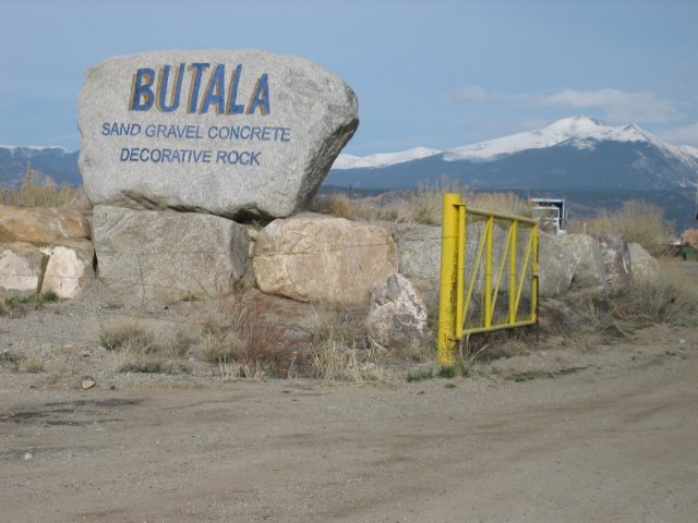
The 120-acre Smeltertown Site is near Salida in Chaffee County, Colorado. Many industrial businesses were on-site over the past century, including lead-zinc smelting and wood-treating businesses. Facility operations contaminated soil, groundwater and surface water. After timber operations ended in 1965, the Butala Construction Company began using the area for sand and gravel mining. EPA began investigating the site in 1986. EPA proposed adding the site to the National Priorities List in 1992 but never finalized the listing. EPA selected cleanup plans for the site in 1996 and 1998. The companies responsible for the contamination removed and placed contaminated materials in an on-site capped repository, which was then fenced. Monitoring of groundwater and surface water in the adjacent Arkansas River is ongoing. Institutional controls restrict land and groundwater use. Today, the Butala Construction Company continues to run a sand-and-gravel quarry on-site. The National Park Service listed the former smelter’s 365-foot smokestack on the National Register of Historic Places in 1976. In 2015, a highway marker highlighting the smokestack’s status and historical importance was installed at the site.
Last updated October 2025
As of December 2025, EPA had data on one on-site business. This business employed 16 people and generated an estimated $980,000 in annual sales revenue. For additional information click here.
For more information:
SMUGGLER MOUNTAIN
The 325-acre Smuggler Mountain Superfund site is in Aspen, Colorado. From 1879 to 1920, silver and lead mines were active on-site. Mining activities created waste containing heavy metals. Piles of exposed waste eventually spread and mixed with area soil. In the 1980s, soil analyses identified high levels of lead and cadmium. To address area-wide contamination, EPA added the site to the National Priorities List in 1986. Cleanup focused on the original mine site, Smuggler Mine and the northeast edge of Aspen. Pitkin County and New Smuggler Mine Corporation led cleanup actions. Activities included covering and revegetating areas of mine waste. The parties also secured former mine areas to prevent further contamination and tested residents’ blood lead levels. After cleanup, EPA took the site off the NPL in 1999. A 116-acre residential area occupies a large part of the site. This area includes condominiums, mobile-home communities, a tennis club and single-family homes. A local company reopened the mine to conduct mineral exploration and to offer tours to Colorado travelers. The mine property also serves as a venue for special events such as weddings and wine tastings. The mine also leases part of its property to a local rafting company. The Smuggler Mountain trailhead is also on-site and provides access to a popular hiking trail. A snack shack next to the trail provides hikers with food and water. Other commercial and industrial businesses are also on-site.
Last updated October 2025
As of December 2025, EPA had data on 18 on-site businesses. These businesses employed 63 people and generated an estimated $5,310,690 in annual sales revenue. For additional information click here.
For more information:
STANDARD MINE
The 10-acre Standard Mine Superfund site is in the Ruby Mining District of Gunnison National Forest in Gunnison County, Colorado. Silver mining began in the southern Ruby Mining District in 1874 and continued at several mine sites in the area until 1974. Standard Mine was one of the three largest silver mines in the Ruby Mining District. Mining activities contaminated soil, surface water and groundwater with heavy metals. EPA added the site to the National Priorities List in 2005 and completed time-critical removal actions in 2006 and 2007. EPA selected the long-term cleanup plan for the site in 2011. The cleanup has two phases. EPA completed the first phase in 2018. EPA conducted source control activities and set up a monitoring program to assess its effectiveness. The results will determine whether the second phase of cleanup, a passive water treatment system, is needed. The U.S. Forest Service owns part of the site. Therefore, EPA and the state of Colorado coordinate with the U.S. Forest Service on all cleanup activities. Recreational uses on-site include hiking and biking in the summer and skiing and snowmobiling in the winter.
Last updated October 2025
As of December 2025, EPA did not have economic data related to on-site businesses, or economic data were not applicable due to site use. For additional information click here.
For more information:
SUMMITVILLE MINE
The 1,400-acre Summitville Mine Superfund site is a former gold mine in Rio Grande County, Colorado. It sits at an elevation of 11,000 feet near the timberline in the San Juan Range of the Colorado Rockies. The area was a gold mine from the late 1800s onward. In 1984, Summitville Consolidated Mining Corporation began open-pit mining for gold, copper and silver. Mining processes contaminated the surrounding area, including Wightman Fork Creek and Terrace Reservoir. Mining operations did not stop until the company announced its pending bankruptcy and informed the state of Colorado that financial support for site operations would not continue beyond December 1992. On December 16, 1992, EPA’s Region 8 started emergency removal actions to address the open-pit mine, contaminated soil and sediment. EPA added the site to the National Priorities List in 1994. Today, EPA and the state have reclaimed and revegetated the former mine lands to prevent further contamination of surrounding creeks and streams. The site is in Rio Grande National Forest and cleanup efforts restored wetlands and native grasses along the Alamosa River. A treatment plant removes metals from acid mine drainage originating at the site. The treatment plant contributes to improving water quality and restoring fish and aquatic life in the Alamosa River and Terrace Reservoir. It uses a significant amount of electricity; EPA and the state have been looking to reduce this expense and footprint. While solar power is not practical at high elevations, the site uses power from a community solar garden in Antonito, a town 40 miles to the south, at a much lower elevation. EPA and the state are looking to expand the use of energy for the site’s water treatment plant through increased input of solar energy from the valley. Snowmobilers and hunters use parts of the site for recreation.
Last updated October 2025
As of December 2025, EPA did not have economic data related to on-site businesses, or economic data were not applicable due to site use. For additional information click here.
For more information:
URAVAN URANIUM PROJECT (UNION CARBIDE CORP.)
The 700-acre Uravan Uranium Project (Union Carbide Corp.) Superfund site is in Uravan, Colorado. A radium recovery plant opened on-site in 1912. From 1936 to 1984, it processed uranium and vanadium. Its activities left wastes behind and contaminated soil and groundwater. EPA added the site to the National Priorities List in 1986. The site is being addressed through state, federal and potentially responsible party actions. Cleanup involved moving more than 3 million cubic yards of mill wastes and contaminated materials to onsite repositories, removing 350 million gallons of liquid waste from groundwater collection, and removing materials and contaminated soil from a 400-acre area around the plant. Cleanup also included dismantled on-site mills, town materials and domestic waste and other structures. The cleanup finished in 2008. EPA took two parts of the site off the NPL in 2005 and 2007. The PRP, the Colorado Department of Public Health and Environment, the U.S. Department of Energy, EPA, Montrose County and the Bureau of Land Management worked together to put institutional controls in place for the site in 2023. In the future, the PRP will transfer the site to the DOE’s Legacy Management program, the BLM and Montrose County. Today, fencing restricts land use. Surrounding land uses consist mostly of fall and winter grazing of beef cattle. Recreational activities near the site include mountain biking, four-wheel driving, camping and rafting. Limited mine reclamation and exploration drilling efforts also take place near the site. Two county roads remain in use on-site.
Last updated October 2025
As of December 2025, EPA did not have economic data related to on-site businesses, or economic data were not applicable due to site use. For additional information click here.
For more information:
VASQUEZ BOULEVARD AND I-70
The Vasquez Boulevard and I-70 Superfund site covers 4.5 square miles in Denver, Colorado. The former Omaha & Grant Smelter and the Argo Smelter were on-site as early as 1878 and were active for nearly a century. Their operations contaminated soil and groundwater. EPA added the site to the National Priorities List in 1999. Cleanup included sampling of over 4,500 residential properties and removal of contaminated soil at about 800 residential properties. Excavated areas were backfilled with clean soil. As part of cleanup efforts, EPA and the Colorado Department of Public Health and Environment’s Community Health Program provided residents with information about health risks. People continue to live on-site. In 2019, EPA took the residential soil part of the site off the NPL. All response actions, apart from maintenance and monitoring, have finished on that part of the site. Investigations and more activities to address contaminated materials at the former smelter locations are ongoing. The former Omaha & Grant Smelter location now hosts a bottling company, the Denver Coliseum, and other commercial and industrial businesses as well as Globeville Landing Park. The former Argo Smelter location is in a commercial and industrial area at the intersection of Interstate 70 and Interstate 25. EPA is working closely with the state and the city and county of Denver to expedite cleanup and support future redevelopment efforts. In 2018, the city completed a drainage project aimed at flood mitigation and better stormwater drainage for the Elyria, Swansea, Cole, Clayton and Globeville neighborhoods. The project will also provide more habitat and recreation opportunities in the area. The city also plans to expand the Regional Transportation District commuter and light-rail system through the FasTracks program, a multi-billion-dollar comprehensive transit expansion plan to build 122 miles of new rail lines, 18 miles of bus rapid transit and 21,000 new parking spaces at light rail and bus stations. At least three of the proposed rail lines – the East Rail Line, the North Metro Line and the Northwest Line – could cross the site. In addition, part of the site will host Fox Park, a 41-acre residential and commercial area. Construction is underway; it will turn this former industrial site into a neighborhood and hub for business and innovation.
Last updated October 2025
As of December 2025, EPA had data on 30 on-site businesses. These businesses employed 1,017 people and generated an estimated $39,174,516 in annual sales revenue. For additional information click here.
For more information:
- Ready for Reuse (RfR) Determination: Vasquez Boulevard and I-70 (PDF)
- Reuse and the Benefit to Community: Vasquez Boulevard & I-70 Superfund Site (PDF)
- Superfund Site Profile Page
WOODBURY CHEMICAL CO.
The 15-acre Woodbury Chemical Co. Superfund site is in Commerce City, Colorado. From the late 1950s to 1971, the Woodbury Chemical Company made pesticides on-site. Production activities and waste disposal practices contaminated soils with hazardous chemicals. Five years after the company ceased operations, the local health department was notified of contaminated storm runoff coming from the vacant lot. EPA added the site to the National Priorities List in 1983. Cleanup activities involved removing on-site contaminated soil and debris, treating it, and taking it off-site for disposal. Cleanup finished in 1992. The remedy did not require any land use restrictions. EPA took the site off the NPL in 1993. A traffic control and transportation services company is now active on part of the site.
Last updated October 2025
As of December 2025, EPA did not have economic data related to on-site businesses, or economic data were not applicable due to site use. For additional information click here.
For more information: