
Climate Adaptation Profile: Port Hadlock – Site 10 North End Landfill
Naval Magazine Indian Island, Washington
Site Description
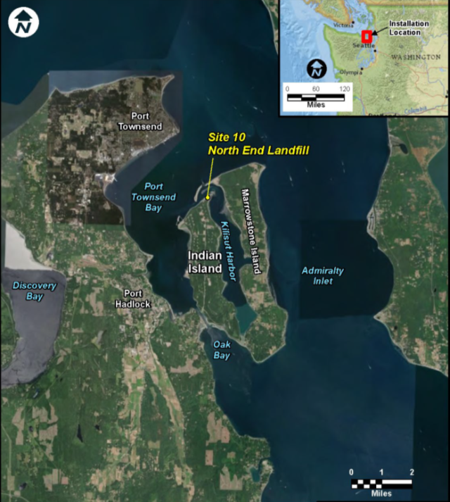
Port Hadlock’s Site 10 borders Port Townsend Bay, a marine inlet at the northeastern extreme of the Olympic Peninsula in Washington. Site 10 formerly served as a landfill for residential and industrial waste, which resulted in soil or groundwater contamination from chemicals including polychlorinated biphenyls, polycyclic aromatic hydrocarbons and metals such as arsenic and lead. Marine waters north of Site 10 are major spawning and nursery areas for fish such as herring and salmon, and certain shellfish inhabit beaches near Site 10.
Remediation Activities
The site remedy involved placing a geosynthetic cap over approximately 3.7 acres, removing eroded landfill debris in the intertidal area, excavating landfill waste from the water’s edge, and constructing a vegetated geogrid and a shoreline protection system along approximately 900 linear feet of the landfill perimeter.
Vulnerability to Climate Change Impacts
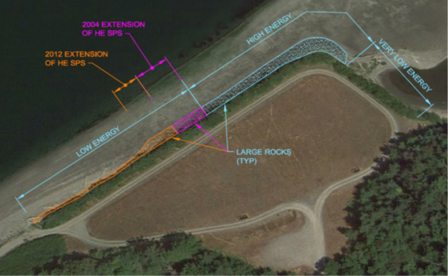
Due to its coastal location, the covered landfill is vulnerable to erosion associated with tidal action and storm surge. A defined analytical process was used to design the shoreline protection system according to three wave-energy regimes. As constructed, the system comprises:
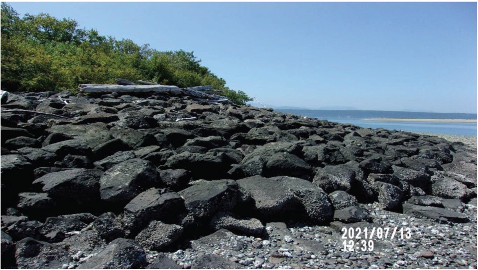
- A high energy section consisting of large stones at the northernmost beach along the landfill.
- A low energy section consisting of large anchored logs at the westernmost beach along the landfill.
- A very low energy section consisting of quarry spalls (riprap) at the tidal lagoon northeast of the landfill.
Modeling results for intermediate-high sea level rise scenarios, as provided in the National Oceanic and Atmospheric Administration’s Sea Level Rise Viewer, now project rises of 1.44, 3.35, and 5.15 feet relative to the mean higher high water level in Port Townsend Bay by the years 2050, 2080 and 2100, respectively.
Building Adaptive Capacity for Future Climate Scenarios
The shoreline protection system was designed and constructed in 1996-1997. During construction mobilization, native willow whips and dune-building grass were collected for later use in constructing the geogrid’s three vegetative layers. Construction of the log revetment system in the low energy section included use of duck-bill anchors at the top of the beach. Before placement of the landfill cover, a gas collection system was installed to equalize wave action-related air pressure under the cap and to vent potential landfill gas.
The U.S. Department of Navy inspects the landfill cap and shoreline protection system semiannually and after storm events. Beach erosion in the low energy/high energy transition zone led to 2004 replacement of a damaged portion of the anchored-log revetment with a rock revetment, and placement of additional armor rock at the low energy/high energy boundary. This maintenance effectively extended the high energy section of the shoreline protection system and reduced potential exposure of landfill debris that may remain in the transition zone.
The site’s intermittent inspections and five-year reviews have provided opportunities to re-evaluate performance of the shoreline protection system and bordering geogrid as well as the landfill capping system. The 2010 five-year review indicated that the shoreline receded during 2008-2009 winter storms, which caused significant erosion and exposed a monitoring well surface seal. The exposed well casing was temporarily protected by hand-placed quarry spalls until the well could be decommissioned in 2011.
Continued wave-related scour and additional erosion in the low energy/high energy transition zone led to further extension of the high energy section in 2012. In 2014, existing armor rock in certain areas delineated by the shoreline protection system’s established transects was relocated and additional material was placed at the low energy/high energy boundary to further strengthen the rock revetment. Repairs in 2019 and 2021 involved adding, adjusting or extending the armor rock in other areas.
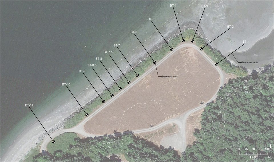
Repairs to the geogrid have involved as-needed replacement of topsoil that was missing due to wave action or manual removal of herbaceous weed species posing a threat to geogrid integrity. As of 2021, a diverse community of native vegetation was thriving in the geogrid area and the landfill cap was in good structural condition, with no sunken or depressed areas or standing water on the cap surface.
The U.S. Department of Navy determined that the current remedy remains protective as long as shoreline monitoring and inspections continue and additional armoring stone is placed as needed in areas vulnerable to erosion. This approach was deemed preferable to more aggressive resilience measures that could negatively affect local shellfish harvests, incur higher costs, or be difficult to sustain. The remedy’s institutional controls involving restricted site access and land use remain in place.
Superfund Climate Resilience
EPA provides additional information about approaches for building climate resilience at Superfund sites.
Overview of Climate Adaptation Measures
The U.S. Department of Navy implemented adaptation measures into design, construction and long-term monitoring of the remedy:
- Used a defined analytical process to design a shoreline protection system according to three different wave-energy regimes and associated erosion potentials.
- Constructed a three-zone shoreline protection system utilizing large stones, anchored logs, or riprap to accommodate high energy, low energy, or very low energy wave regimes, respectfully.
- Constructed a geogrid vegetated with wave- and saltwater-tolerant plants to further protect the shoreline abutting the covered landfill.
- Installed a gas-collection system to equalize wave action-related air pressure under the landfill cap.
- Established institutional controls to prevent future activities that could damage the shoreline protection system or vegetated geogrid.
- Adding additional armor rock to vulnerable or damaged portions of the shoreline protection system as needed after major storms or due to gradual shoreline changes.
- Implementing a long-term shoreline monitoring and maintenance program to assure continued resilience to tidal action and storm surge.
Key Tools for Incorporating Climate Projections
Points of Contact
- Chan Pongkhamsing, U.S. EPA Region 10
- Christopher Maurer, Washington Department of Ecology
- William H. Kalina, Jr. , Naval Magazine Indian Island
References
- 2016 NAVFAC fact sheet (ESAT N62583-11-D-0515 TO 0082)
- Fifth Five-Year Review: Naval Magazine Indian Island, May 2020, Naval Facilities Engineering Command
- Summer 2021 Inspection Report: Landfill and Shoreline Protection System, Operation and Maintenance, Site 10 North End Landfill, Naval Magazine Indian Island
February 2022