U.S. flag

An official website of the United States government

Here’s how you know

Dot gov

Official websites use .gov
A .gov website belongs to an official government organization in the United States.

HTTPS

Secure .gov websites use HTTPS
A lock (LockA locked padlock) or https:// means you’ve safely connected to the .gov website. Share sensitive information only on official, secure websites.

    • Environmental Topics
    • Air
    • Bed Bugs
    • Cancer
    • Chemicals, Toxics, and Pesticide
    • Emergency Response
    • Environmental Information by Location
    • Health
    • Land, Waste, and Cleanup
    • Lead
    • Mold
    • Radon
    • Research
    • Science Topics
    • Water Topics
    • A-Z Topic Index
    • Laws & Regulations
    • By Business Sector
    • By Topic
    • Compliance
    • Enforcement
    • Laws and Executive Orders
    • Regulations
    • Report a Violation
    • Environmental Violations
    • Fraud, Waste or Abuse
    • About EPA
    • Our Mission and What We Do
    • Headquarters Offices
    • Regional Offices
    • Labs and Research Centers
    • Planning, Budget, and Results
    • Organization Chart
    • EPA History

Breadcrumb

  1. Home
  2. EnviroAtlas
  3. How to Use

Tutorials

Learn how to use the EnviroAtlas Interactive Map, an easy-to-use tool that allows users to discover, analyze, and download geospatial data related to ecosystem services, their stressors, and human health. 

Interactive Tutorial Story Map

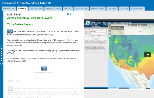
The tutorial story map is an interactive guide to learn about the EnviroAtlas mapping application. The Story Map contains short video clips (< 30 seconds) and guidance text describing available tools, features, and functions.  Navigate to different tabs in the story map for guidance on topics of interest. 

Screen capture of tutorial story map
Screen capture of the Main Panel portion of the story map

Some of the topics available in the story map include:

  • Access National, Community, and Demographic Data
  • Use Analysis Tools
  • Save Your Map Session
  • Your Own Data

Get started with the tutorial story map.

YouTube training videos

Want to see demonstration videos but don't need step-by-step guidance?  Try our Video Tutorial Library.

The embedded video below is one example of the available video tutorials. There are 26 short tutorial videos (<30  seconds long) with no sound. 

Guides

  • This Quick Start Guide provides a 1-page visual overview of the EnviroAtlas Interactive Map features and functions. 
  • The EnviroAtlas Help page provides guidance on the interactive map. This replaces the previous users guide that was available.

EnviroAtlas

  • About Us
    • Ecosystem Services
    • Frequent Questions
    • Project Status
  • Web Apps
    • Interactive Map
    • Eco-Health Browser
  • How to Use
    • Tutorials
    • Example Uses
    • For Brownfields
    • Health Impact Assessment
  • Data
    • About the Data
    • Dynamic Data Matrix
    • Download
  • Resources & Publications
    • Educational Materials
    • Fact Sheets
    • Publications
  • Technical Resources
    • GIS Toolboxes
  • Related Links
Contact Us about EnviroAtlas
Contact Us to ask a question, provide feedback, or report a problem.
Last updated on April 2, 2025
  • Assistance
  • Spanish
  • Arabic
  • Chinese (simplified)
  • Chinese (traditional)
  • French
  • Haitian Creole
  • Korean
  • Portuguese
  • Russian
  • Tagalog
  • Vietnamese
United States Environmental Protection Agency

Discover.

  • Accessibility Statement
  • Budget & Performance
  • Contracting
  • EPA www Web Snapshot
  • Grants
  • No FEAR Act Data
  • Plain Writing
  • Privacy
  • Privacy and Security Notice

Connect.

  • Data
  • Inspector General
  • Jobs
  • Newsroom
  • Regulations.gov
  • Subscribe
  • USA.gov
  • White House

Ask.

  • Contact EPA
  • EPA Disclaimers
  • Hotlines
  • FOIA Requests
  • Frequent Questions
  • Site Feedback

Follow.