U.S. flag

An official website of the United States government

Here’s how you know

Dot gov

Official websites use .gov
A .gov website belongs to an official government organization in the United States.

HTTPS

Secure .gov websites use HTTPS
A lock (LockA locked padlock) or https:// means you’ve safely connected to the .gov website. Share sensitive information only on official, secure websites.

    • Environmental Topics
    • Air
    • Bed Bugs
    • Cancer
    • Chemicals, Toxics, and Pesticide
    • Emergency Response
    • Environmental Information by Location
    • Health
    • Land, Waste, and Cleanup
    • Lead
    • Mold
    • Radon
    • Research
    • Science Topics
    • Water Topics
    • A-Z Topic Index
    • Laws & Regulations
    • By Business Sector
    • By Topic
    • Compliance
    • Enforcement
    • Laws and Executive Orders
    • Regulations
    • Report a Violation
    • Environmental Violations
    • Fraud, Waste or Abuse
    • About EPA
    • Our Mission and What We Do
    • Headquarters Offices
    • Regional Offices
    • Labs and Research Centers
    • Planning, Budget, and Results
    • Organization Chart
    • EPA History

Breadcrumb

  1. Home
  2. Facility Registry Service (FRS)

EPA Regional KML Download

System Data Searches

To improve public health and the environment, the EPA collects information about facilities or sites subject to environmental regulation. The EPA Geospatial Data Access Project provides downloadable files of these facilities or sites in the following formats; Extensible Markup Language (XML) file, Keyhole Markup Language (KML) file, Environmental Systems Research Institute (ESRI) Shapefile, ESRI Geodatabase, and Comma Separated Value (CSV). Within the file is key facility information, along with associated environmental interests for use in mapping and reporting applications. Because of the large size of the National KML file, this html page provides subsets of the National file based on EPA Region. The home page of the EPA Geospatial Data Project contains downloadable National files in XML, KML, Shapefile, Geodatabase and XML formats. If you find erroneous data with the download file(s), please click on the "Report an Error" button to notify the EPA of data errors.

  • Geospatial Data Download Service homepage

We've updated all of our download files to contain information collected from our Featured Environmental Interests.

EPA has ten regional offices, each of which is responsible for several states and territories. The regions are divided as shown on the map below. Click on a region below to download the KML file for that region.

Region1: Connecticut, Maine, Massachusetts, New Hampshire, Rhode Island, Vermont Region 2: New Jersey, New York, Puerto Rico, US Virgin Islands Region 3: Delaware, District of Columbia, Maryland, Pennsylvania, Virginia, West Virginia Region 4: Alabama, Florida, Georgia, Kentucky, Mississippi, North Carolina, South Carolina, Tennessee Region 5: Illinois, Indiana, Michigan, Minnesota, Ohio, Wisconsin Region 6: Arkansas, Louisiana, New Mexico, Oklahoma, Texas Region 7: Iowa, Kansas, Missouri, Nebraska Region 8: Colorado, Montana, North Dakota, South Dakaota, Utah, Wyoming Region 9: Arizona, California, Hawaii, Nevada, Pacific Islands Region 10: Alaska, Idaho, Oregon, Washington

FRS Physical Data Model

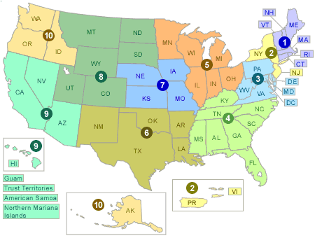
Region 1: Connecticut, Maine, Massachusetts, New Hampshire, Rhode Island, Vermont
Region 2: New Jersey, New York, Puerto Rico, US Virgin Islands
Region 3: Delaware, District of Columbia, Maryland, Pennsylvania, Virginia, West Virginia
Region 4: Alabama, Florida, Georgia, Kentucky, Mississippi, North Carolina, South Carolina, Tennessee
Region 5: Illinois, Indiana, Michigan, Minnesota, Ohio, Wisconsin
Region 6: Arkansas, Louisiana, New Mexico, Oklahoma, Texas
Region 7: Iowa, Kansas, Missouri, Nebraska
Region 8: Colorado, Montana, North Dakota, South Dakota, Utah, Wyoming
Region 9: Arizona, California, Hawaii, Nevada, Pacific Islands
Region 10: Alaska, Idaho, Oregon, Washington

Facility Registry Service Links

  • Facility Registry Service (FRS) Overview
  • Geospatial Overview
  • Office of Information Management (OIM)

System Data Searches

  • Multisystem
  • BR
  • Brownfields/Cleanups
  • Cleanups
  • ECHO/IDEA
  • FRS
    • EZ Search
    • Organization Search
  • Greenhouse Gas
    • Customized Search
  • ICIS
  • ICIS-AIR
  • ICR
  • Locational Information
    • Locational Search
  • NEI
  • PCS
    • Customized Search
  • RadNet
    • Customized Search
  • RCRAInfo
  • SDWIS
  • SEMS
  • SRS
  • TRI
    • TRI Explorer
    • TRI Search
    • Form R Search
    • Form R & A Download
    • EZ Search
    • Customized Search
    • Pollution Prevention
  • TSCA
  • UV Index

Other Sites of Interest

  • Geospatial Download
  • EnviroMapper
  • MyEnvironment

Facility Registry Service (FRS)

  • FRS Query
Contact Us About FRS
Contact Us to ask a question, provide feedback, or report a problem.
Last updated on May 30, 2024
  • Assistance
  • Spanish
  • Arabic
  • Chinese (simplified)
  • Chinese (traditional)
  • French
  • Haitian Creole
  • Korean
  • Portuguese
  • Russian
  • Tagalog
  • Vietnamese
United States Environmental Protection Agency

Discover.

  • Accessibility Statement
  • Budget & Performance
  • Contracting
  • EPA www Web Snapshot
  • Grants
  • No FEAR Act Data
  • Plain Writing
  • Privacy
  • Privacy and Security Notice

Connect.

  • Data
  • Inspector General
  • Jobs
  • Newsroom
  • Regulations.gov
  • Subscribe
  • USA.gov
  • White House

Ask.

  • Contact EPA
  • EPA Disclaimers
  • Hotlines
  • FOIA Requests
  • Frequent Questions
  • Site Feedback

Follow.