
FRS Description
Facility Registry Service (FRS) is an EPA system used to take in reported physical site information from different federal, state, local, and tribal source systems (e.g., program systems) and combine them into one database to enable information sharing and provide attempted site matching. FRS is integrated with the Central Data Exchange to power facility data validation and input. FRS is run by Office of Information Management (OIM).
FRS Data
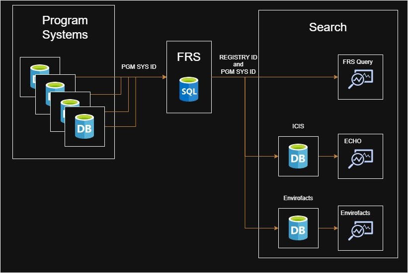
FRS is made up of data from 90 systems inputting site data into FRS. Any source in the list FRS Data Sources is also called a "program system" which includes EPA program systems, (e.g., TRI), and state systems, (e.g., CARB-TCH).
Records in FRS are given an FRS ID, (also called Registry ID), that then have program records linked to the FRS ID. An FRS ID is in the format of (110012345678). For example, this FRS test record is FRS ID 110071730304 with a linked TSCA program record of TSCA10206722.
Data refreshes generally happen periodically so a business submitting an update will not be reflected in FRS right away. To see the last system data refresh data and then next scheduled refresh, see the FRS data updates dashboard.
EPA program systems act as the "source of truth" with data captured by the EPA. FRS then acts as a master data management system by attempting to add data to each program system record input into FRS and match similar sites. An example of adding data, FRS completes the best pick process weekly to add a latitude and longitude for a new address. FRS applies an FRS ID (Registry ID) to the program record before the best pick process runs. FRS attempts to match new reported sites to existing sites.
This FRS information is published publicly for research and review by creating multiple search tools and APIs to search this data. Additionally FRS allows internal EPA users to update FRS records based on site owner update requests. Note that records from a source system (e.g. a program record) cannot be updated by EPA employees in FRS.
Data Standards
- FRS Parser and Standardization Process
Describes the name and address standardization and parser procedures - Facility Site Identification Data Standard
2006 The EPA Facility Site Identification Data Standard, Version 2.0, 2006-01-06 - Facility Identification Template for States, Version 2
Guidelines provided by the States for facility identification
Programs and Interests
- Environmental Interest Types
Descriptions of environmental interests (permits or regulatory programs), sorted by program categories (e.g., Air Programs, Animal Operations) - Program Crosswalks
Data element mappings between the major EPA programs and FRS - Reported Interest Types Mapped to Standardized Interest Types
A list of State reported Interest Types mapped to standardized FRS Interest Types
Looking to Connect your government system to FRS?
For new connections to FRS by federal, state, local, and tribal government systems, our team recommends reading the 2021 Intergovernmental FRS API and reaching out to the FRS team to discuss connecting to FRS.
Data Exchange
This is a legacy data flow called FacID for state and tribal systems to connect to FRS. For new connections to FRS our team recommends using the 2021 Intergovernmental FRS API.
- FRS on the Exchange Network
- FacID v3.0 Best Practices
Discusses common issues that may occur while setting up an inbound legacy FacID 3.0 data exchange with FRS through the Exchange Network - EPA Data Exchange Flat File Format Specification
Defines the flat file formats to be used to transfer facility identification information to the FRS for states or tribes that do not have access to the Exchange Network - 2013 FacID - Legacy CDX Data Flow with FRS Setup Guide
2013 description of information needed from a national program system to set up a data flow with FRS
FRS Spatial Processing & GIS References
- 2021 FRS Best Pick Processing
The FRS process to determine the "best pick" latitude and longitude location for a facility - 2013 Overview of FRS Spatial Processing
Overview of FRS Spatial Processing which includes "best pick" process - 2013 FRS Geospatial Structures
Overview of 2013 update to existing geospatial structures - 2013 FRS Geospatial Model
2013 FRS geospatial model - 2013 GIS Data Integration
The GIS data integration process
FRS Related Links
- System of Registries
EPA list of systems (includes FRS) hosted by the EPA that gives users access to EPA data
Who's Who in FRS
| Stakeholders | Who They Are |
|---|---|
| Public | Students and teachers, industry, and environmental groups |
| Environmental Protection Agency | Programs, regions, decision makers, emergency responders, researchers, analysts and GIS professionals |
| FRS Primary Data Stewards | EPA staff who act as champions for high-quality facility data, ensuring data curation and maintaining accurate linkages between facility records. Also review and approve data corrections submitted by Secondary and Other (State/Tribal) Stewards. |
| Secondary Data Stewards (State/Tribal/Program/Other) | State, Tribal, Program, and Other Data Stewards who review facility data and suggest data quality improvements for facility data |
| Exchange Network | A partnership among states, tribes, territories, and EPA for the exchange of environmental information efficiently and securely over the internet |