U.S. flag

An official website of the United States government

Here’s how you know

Dot gov

Official websites use .gov
A .gov website belongs to an official government organization in the United States.

HTTPS

Secure .gov websites use HTTPS
A lock (LockA locked padlock) or https:// means you’ve safely connected to the .gov website. Share sensitive information only on official, secure websites.

    • Environmental Topics
    • Air
    • Bed Bugs
    • Cancer
    • Chemicals, Toxics, and Pesticide
    • Emergency Response
    • Environmental Information by Location
    • Health
    • Land, Waste, and Cleanup
    • Lead
    • Mold
    • Radon
    • Research
    • Science Topics
    • Water Topics
    • A-Z Topic Index
    • Laws & Regulations
    • By Business Sector
    • By Topic
    • Compliance
    • Enforcement
    • Laws and Executive Orders
    • Regulations
    • Report a Violation
    • Environmental Violations
    • Fraud, Waste or Abuse
    • About EPA
    • Our Mission and What We Do
    • Headquarters Offices
    • Regional Offices
    • Labs and Research Centers
    • Planning, Budget, and Results
    • Organization Chart
    • EPA History

Breadcrumb

  1. Home
  2. Global Change Explorer (GCX)
  3. Integrated Land Use

ICLUS Fourth National Climate Assessment

On this page:
  • National
  • Northwest
  • Southwest
  • Northern Plains
  • Southern Plains
  • Midwest
  • Northeast
  • Southeast
National Map
This map indicates the regions that group the states together for the purpose of providing national climate assessment datasets and population projections.
The map of the U.S. above illustrates the regional demarcations for the presentation of datasets and population projections.

ICLUS (version 2) outputs made available to the regional groups of the National Climate Assessment consist of populations. The projections are based on the 2010 U.S. Census and use fertility, mortality and immigration rates from the Wittgenstein Centre to project decadal population to 2100. These projections are therefore consistent with the demographic assumptions of the SSP2 and SSP5 socioeconomic scenarios. ICLUS population projections are used as inputs to a land use model, which spatially allocates five residential land uses (exurban-low, exurban-high, suburban, urban-low, urban-high) as well as commercial and industrial.

Datasets available below cover the contiguous United States. All datasets are compatible with standard geographic information systems.

Dataset Description Metadata
Population Data (SSP2 & SSP5) 9.83 MB, Shapefile format Population Projections
Land Use Data (SSP2) 1.63 GB, GeoTIFF format ICLUS v2.1 Land Use Projections (SSP2)
Land Use Data (SSP5) 1.66 GB, GeoTIFF format ICLUS v2.1 Land Use Projections (SSP5)

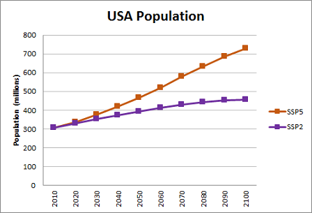
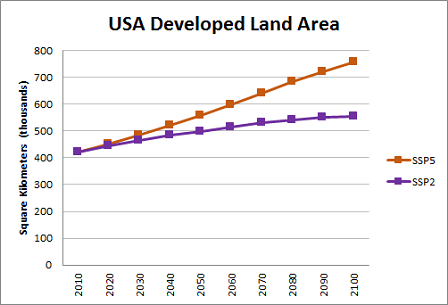
The graphs below provide an overview of population and developed land area trends across the two scenarios, SSP2 and SSP5, over time for the continental U.S.

Chart showing the increase trend projection of the U.S. population.
Download  Population Trend Data using ICLUS Version 2 Datasets (xlsx) (30.57 KB)
Chart showing the increase land use of the U.S. population.
Download  Developed Landuse Data using ICLUS Version 2 Datasets (xlsx) (33.7 KB)

Related Links

Additional Information about ICLUS

  • Learn more about the recent Updates to the Demographic and Spatial Allocation Models to Produce Integrated Climate and Land Use Scenarios (ICLUS) (Version 2.0)
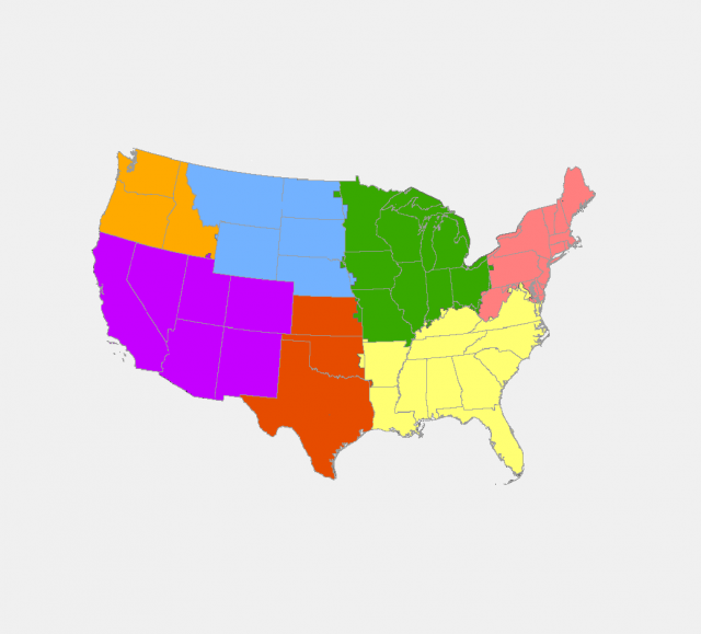
  • 3rd National Climate Assessment:  ICLUS data made available to the regional groups of the National Climate Assessment consists of population and housing density. [Links:  Northwest | Southwest | Great Plains | Midwest | Northeast | Southeast]

Global Change Explorer (GCX)

  • Critical Loads
  • Ecosystem Management
    • Adaptation Design for Coral Reef Restoration
    • Adaptation Design Tool
    • Delaware Bay Wetland Projections
  • Integrated Land Use
    • 4th National Climate Assessments
    • ICLUS Downloads
  • Location Scenarios
  • Resilience
  • Watersheds
Contact Us about GCX
Contact Us to ask a question, provide feedback, or report a problem.
Last updated on January 18, 2025
  • Assistance
  • Spanish
  • Arabic
  • Chinese (simplified)
  • Chinese (traditional)
  • French
  • Haitian Creole
  • Korean
  • Portuguese
  • Russian
  • Tagalog
  • Vietnamese
United States Environmental Protection Agency

Discover.

  • Accessibility Statement
  • Budget & Performance
  • Contracting
  • EPA www Web Snapshot
  • Grants
  • No FEAR Act Data
  • Plain Writing
  • Privacy
  • Privacy and Security Notice

Connect.

  • Data
  • Inspector General
  • Jobs
  • Newsroom
  • Regulations.gov
  • Subscribe
  • USA.gov
  • White House

Ask.

  • Contact EPA
  • EPA Disclaimers
  • Hotlines
  • FOIA Requests
  • Frequent Questions
  • Site Feedback

Follow.