
Superfund Sites in Reuse in Oregon
If you are having trouble viewing the map in your browser, click the 'View larger map' link below
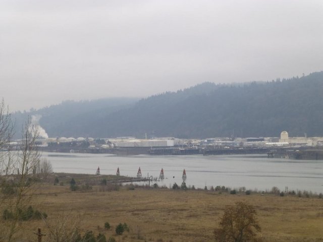
ASTORIA MARINE CONSTRUCTION COMPANY
The 8-acre Astoria Marine Construction Company site is in Astoria, Oregon, along the east bank of the Lewis and Clark River. It includes a boat shop complex, several facility buildings and low-lying land next to tidal flats. Astoria Marine Construction Company began operating a marine shipyard on-site in 1924. The company primarily made fishing boats and luxury sailing vessels. During World War II, the shipyard made and repaired over 200 ships for the U.S. Navy, including minesweepers and escort aircraft carriers. From 1950 to 1955, AMCCO also built minesweepers for the Korean War. Site activities contaminated the soil, sediment and groundwater with hazardous chemicals. In 1996, the Oregon Department of Environmental Quality identified environmental concerns at the site. EPA led an investigation in 2009. The agency found that poor waste management practices led to an accumulation of hazardous chemicals on the property and in river sediments. In 2011, EPA proposed listing the site on the National Priorities List. In 2012, EPA postponed the listing and deferred cleanup guidance to the ODEQ. In 2017, the ODEQ selected a site remedy. AMCCO began the cleanup in July 2020 and completed construction in 2022. Cleanup activities included the demolition of structures, the restoration of a levee, the excavation and off-site disposal of contaminated sediment, the removal of contaminated soil, and the capping of multiple site areas. The ODEQ will continue to monitor the in-water remedy to confirm the cleanup's effectiveness. The first round of sediment performance monitoring is anticipated for 2024. Operation and maintenance activities are ongoing, led by the ODEQ. In 2013, the National Park Service listed the Astoria Marine Construction Company on the National Register of Historic Places for its contributions to World War II and the Korean War. Currently, a marine construction company makes and repairs small marine vessels on-site.
Last updated October 2025
As of December 2025, EPA had data on one on-site business. This business employed 4 people and generated an estimated $398,090 in annual sales revenue. For additional information click here.
For more information:
BLACK BUTTE MINE
The Black Butte Mine Superfund site is near Cottage Grove, Oregon. Mercury mining from the late 1880s to the late 1960s included extracting ore from the mine, crushing it on site, roasting it in kilns to volatilize the mercury, and bottling and shipping the mercury. Mining operations, tailings piles left at the site, and erosion from the site contaminated soil, sediment, surface water, groundwater and biological organisms such as fish with mercury and other metals. Mercury contamination in the fish of Cottage Grove reservoir led to the first fish advisory in Oregon in 1979. EPA added the site to the National Priorities List in 2010. To manage the cleanup, EPA divided the site into three areas, or operable units: Black Butte Mine (OU-1), Coast Fork Willamette River (OU-2) and Cottage Grove Reservoir (OU-3). The Black Butte Mine area includes the abandoned mine, associated waste and nearby creeks. In 2007, early cleanup actions by EPA included removing and stabilizing contaminated mine wastes. In 2018, EPA cleaned up Furnace Creek, one of the most contaminated parts of the site. In 2019, EPA also removed more than 1,500 cubic yards of contaminated soil from the former ore processing area. The Oregon Health Authority posted an updated “green” fish health advisory for Cottage Grove Reservoir in 2012. “Green” fish advisories are issued when sport-caught fish such as rainbow trout can be eaten as part of a healthy diet at the recommended level of eight meals per month or more. . In 2020, EPA completed the remedial investigations (RI) for the mine site OU-1 and the OU-2 RI was completed in 2025. EPA is currently finalizing the RI for OU-3. The RI process also included an evaluation of risk posed to both people and the environment through finalization of Baseline Human Health Risk Assessment and Baseline Ecological Risk Assessment documents. EPA is currently working on the Feasibility Study (FS) for OU-1 and OU-2, a process that evaluates and compares cleanup alternatives to determine the most effective and suitable solution for protecting human health and the environment. Data collection for key FS objectives will occur in the Summer of 2025. After the FS is finalized and a Record of Decision is completed, the site cleanup will be implemented with site reuse options or opportunities determined at that time. The U.S. Army Corps of Engineers (USACE) owns and manages the reservoir for flood control and recreation at OU3. The Coast Fork Willamette River and Cottage Grove Reservoir support camping, birding, boating, swimming and fishing. The USACE completed an updated Master Plan and Environmental Assessment for Cottage Grove Reservoir (2025), primarily a land use and outdoor recreation strategic plan to address regional as well as individual lake resource needs and aspirations. Other site uses include timber production, agriculture and wildlife habitat. The Coast Fork Willamette River corridor is private property including single family residential, Weyerhaeuser timber, and agriculture.
Last updated October 2025
As of December 2025, EPA did not have economic data related to on-site businesses, or economic data were not applicable due to site use. For additional information click here.
For more information:
EAST MULTNOMAH COUNTY GROUND WATER CONTAMINATION
The East Multnomah County Ground Water Contamination site is in northeastern Multnomah County, Oregon. It consists of areas above the Troutdale Gravel Aquifer and the Troutdale Sandstone Aquifer. Two manufacturing facilities owned by Cascade Corporation and Boeing of Portland opened on-site in the 1950s. Facility wastes were improperly disposed of during past operations. Investigations began in 1988, after the discovery of soil contamination during the decommissioning of underground storage tanks. Sampling also found groundwater contamination in the aquifers below the site. EPA proposed adding the site to the National Priorities List in 1993 but did not finalize the listing. Cleanup efforts by the facility owners include pumping and treating groundwater using extraction wells, air strippers and carbon treatment. Cleanup is ongoing. The two facilities remain active on-site. Other uses at the site include an organic produce wholesaler, a grocery distribution center and a construction company.
Last updated October 2025
As of December 2025, EPA did not have economic data related to on-site businesses, or economic data were not applicable due to site use. For additional information click here.
For more information:
FORMOSA MINE
The 120-acre Formosa Mine Superfund site is located on Silver Butte in Douglas County, Oregon. Mining for copper and silver took place on-site from about 1910 to 1937. In 1990, Formosa Exploration, Inc. reopened the mine. When mining operations ended in 1993, the mine was filled with mill tailings, crushed ore, concentrates and other mine materials. Tailings and low-grade ore from the mine were put in a lined cell and capped. Acidic water, called acid rock drainage, continues to be released from the site. Past mining operations and improper mine closure contaminated soil, sediment, surface water and groundwater with heavy metals. EPA added the site to the National Priorities List in 2007. Cleanup includes digging up contaminated soil, sediments and materials and putting them in a containment facility on-site. It also includes capping contamination on-site. In 2018 and 2019, EPA and the Bureau of Land Management led emergency removal actions to prevent water discharges from further contaminating surface water near the site. In 2021, the site was among those selected by EPA to receive additional cleanup funding. With this funding, EPA is working on backlogged remedial construction projects and accelerating cleanups at NPL sites. EPA’s goal with this funding is to manage former mine materials at part of the site to minimize exposure to mine-related contaminants for people, animals and plants, including threatened and endangered species. EPA will also lead a remedial investigation and feasibility study to better understand and address contamination in surface water and groundwater at the site. Cleanup and monitoring activities are ongoing. Recreation activities nearby include hunting, hiking, camping and all-terrain vehicle use. Parts of the site are designated critical habitat for federal and state species, including the northern spotted owl, coastal coho salmon, coastal cutthroat trout and Oregon coast steelhead.
Last updated October 2025
As of December 2025, EPA did not have economic data related to on-site businesses, or economic data were not applicable due to site use. For additional information click here.
For more information:
MARTIN-MARIETTA ALUMINUM CO.
The Martin-Marietta Aluminum Co. Superfund site is in The Dalles, Oregon. Smelting operations began at the facility in 1958 and ended in 1984. These operations contaminated large parts of the 350-acre site. EPA added the site to the National Priorities List in 1987. With EPA’s oversight, Martin-Marietta removed hundreds of tons of waste and placed it in a capped landfill. After cleanup, EPA took the site off the NPL in 1996. Monitoring and operation and maintenance activities are ongoing. In 1986, Northwest Aluminum Company leased and reopened the aluminum production plant. NAC made aluminum at the site until 2003. From 2007 to 2011, NAC demolished buildings and removed more contaminated soil with state oversight. The site now includes two closed landfills. The city, the county, and the port of The Dalles are interested in redeveloping non-landfill parts of the site for industrial, utility, and commercial purposes. In 2021, EPA’s Superfund Redevelopment Program began providing reuse planning support for the site. An aluminum production facility remains active on-site.
Last updated October 2025
As of December 2025, EPA had data on one on-site business. This business employed 60 people and generated an estimated $30,800,000 in annual sales revenue. For additional information click here.
For more information:
MCCORMICK & BAXTER CREOSOTING CO. (PORTLAND PLANT)
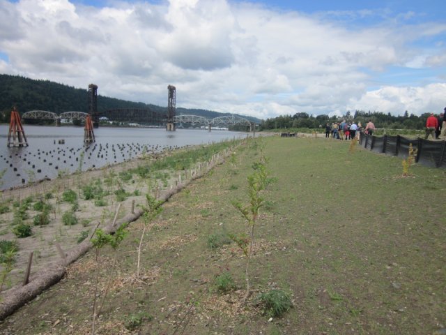
The McCormick & Baxter Creosoting Co. (Portland Plant) Superfund site is on the Willamette River in Portland, Oregon. It includes a 43-acre upland facility and 23 acres of sediment in the Willamette River. From 1944 to 1991, wood-treating operations took place on-site. From 1950 to 1965, operators applied waste oil containing creosote and/or PCP to site soils in the central processing area for dust suppression. Operators put liquid process wastes in a low area near the tank farm prior to 1971. From 1968 to at least 1973, operators put residues from the retorts, oil/water separator and evaporators in a waste disposal area on the western part of the site. The facility included a wastewater discharge outfall. Operators used the outfall to discharge cooling water and contact wastewater to the river during plant operations. Two major creosote spills occurred in 1950 and 1956, in and near the tank farm area. Wood-treating activities ended in 1991. The Oregon Department of Environmental Quality found that wood-treating operations contaminated site soils, groundwater, and river sediments. EPA added the site to the National Priorities List in 1994. The ODEQ cleaned up the site with EPA’s oversight and funding. The ODEQ removed and disposed of wood-treating wastes and contaminated soils, removed on-site buildings and placed a soil cap over the upland part of the site. It also placed a subsurface barrier wall around the contamination and collected and treated contaminated groundwater until 2011. In 2004, the ODEQ put in a 23-acre sediment cap that continues to protect the Willamette River, an ecological and recreational resource in the heart of Portland. EPA and the ODEQ continue to monitor the caps and the subsurface barrier wall. During cleanup, the ODEQ revegetated the former facility area with native plant species that prevent erosion. Cottonwoods, willows and spiraea now cover the riverbanks. Even before cleanup reached completion, interested parties began looking at potential redevelopment opportunities for the site. In 2001, Portland’s Bureau of Planning and Sustainability did a reuse assessment, funded by a grant from EPA’s Superfund Redevelopment Program. The assessment, endorsed by Portland City Council, clarified that likely future uses at the site include recreational uses. Since 2018, SRP has also funded a regional support project to facilitate reuse discussions among local stakeholders and evaluate long-term site ownership and stewardship options. In 2020, the city updated its 2035 Comprehensive Master Plan, which changed site zoning from Heavy Industrial to General Employment. This zoning is more flexible and allows for parks and open space as well as educational institutions. The Willamette River part of the site remains in continued recreational use.
Last updated October 2025
As of December 2025, EPA did not have economic data related to on-site businesses, or economic data were not applicable due to site use. For additional information click here.
For more information:
- Reuse Fact Sheet: McCormick & Baxter Creosoting Co. (Portland Plant) Superfund Site (PDF)
- Superfund Site Profile Page
NORTHWEST PIPE & CASING/HALL PROCESS COMPANY

The 53-acre Northwest Pipe & Casing/Hall Process Company Superfund site is in Clackamas, Oregon. Pipe manufacturing and coating operations were on-site from 1956 to 1985. Improper waste disposal activities resulted in contamination of soil and groundwater. EPA added the site to the National Priorities List in 1992. Cleanup included demolition and removal of all infrastructure, removal and off-site disposal of contaminated soils, placement of a clean soil cap over contaminated areas of soil, and treatment of contaminated groundwater. Groundwater monitoring is ongoing. The site consists of two parcels. The first, Parcel A, consists of an 11-acre western lot and a 9-acre eastern lot. The second parcel, Parcel B, is a 30-acre lot. The Oregon Department of Transportation (ODOT) owns the 11-acre western lot of Parcel A. The ODOT runs a warehouse, office space and an equipment yard on the lot. An automated card-lock fueling station is also on the eastern side of the equipment yard. The Wilshire Clackamas Commerce Center Owner LLC owns the 9-acre eastern lot of Parcel A, that includes the Clackamas Commerce Park, consisting of three warehouse/office spaces and associated parking lots. Clackamas County Development Agency purchased Parcel B in 2005. In 2010, the agency leased the parcel to Vigor (formerly Oregon Iron Works). Vigor completed a laydown yard in the northeast corner of Parcel B in fall 2009. In summer 2010, Vigor opened a streetcar test track and maintenance facility on the southern half of Parcel B. In 2011, Vigor installed a 30.8-kilowatt solar array on-site. Each year, it offsets about 30,700 kilowatt hours of energy generated from conventional sources. Parcel B also includes a wetland and a wetland buffer area that are part of the remedy. The ODOT has extended two roads across the capped part of the site, the Sunrise Expressway and Minuteman Way. The Sunrise Expressway opened in 2016; it helps relieve regional traffic congestion. Minuteman Way, which runs along the western part of the site, has enhanced area infrastructure and includes bike lanes and sidewalks.
Last updated October 2025
As of December 2025, EPA had data on 6 on-site businesses. These businesses employed 93 people and generated an estimated $16,629,385 in annual sales revenue. For additional information click here.
For more information:
- Reuse and the Benefit to Community: Northwest Pipe & Casing/Hall Process Company Case Study (2015) (PDF)
- Superfund Site Profile Page
PORTLAND HARBOR
The Portland Harbor Superfund site is in Portland, Oregon. The site includes a 10-mile stretch of the lower Willamette River known as Portland Harbor and associated upland source properties. For over 150 years, Portland Harbor has served as an international port for commerce. Surrounding properties have supported manufacturing, shipbuilding, petroleum, metal salvaging, power generation and other activities. These industrial uses resulted in contamination of the river sediments, upland soil and groundwater at riverfront properties. EPA added the site to the National Priorities List in 2000. EPA selected the site’s final cleanup plan in 2017 and updated it in 2019. The plan addresses about 380 acres of contaminated sediments and 22,600 feet of riverbank. It involves dredging, capping, enhanced and monitored natural recovery, and an estimated 60 acres of compensatory mitigation. The river is an important pathway for the migration of fish such as salmon and lamprey. Fishing for salmon, sturgeon and other species takes place along the lower Willamette River. The river is also important to many Tribes in the region, some of which are actively involved in the cleanup oversight effort. Fish are among the resources most frequently used by the Tribes in the Portland Basin and the Willamette Valley. The Tribes continue to gather native plants for food and medicinal purposes. Tribes have reserved hunting, fishing (particularly salmon and sturgeon) and certain gathering rights through treaties with the United States. These activities provide food, cultural heritage, knowledge and skills for Tribal families. Through an agreement with EPA, the University of Portland purchased the 35-acre Triangle Park area of the site in 2008. The University cleaned up the area with oversight from the agency and is using it as an expansion of its existing campus, with athletic fields and a trail for public access to the Willamette River waterfront. Additionally, EPA’s Superfund Redevelopment Program is providing in-kind planning assistance to gather information about future use goals for the site. The planning assistance has included information gathering from the city, property owners and community partners in the area to better understand the range of future use goals and considerations. The outcome was a document summarizing the information gathered, including preliminary future goals, land use context, local initiatives, key stakeholder interests and reuse considerations. Currently, recommendations from that document are being implemented.
Last updated October 2025
As of December 2025, EPA had data on 86 on-site businesses. These businesses employed 4,024 people and generated an estimated $1,803,755,687 in annual sales revenue. For additional information click here.
For more information:
REYNOLDS METALS COMPANY
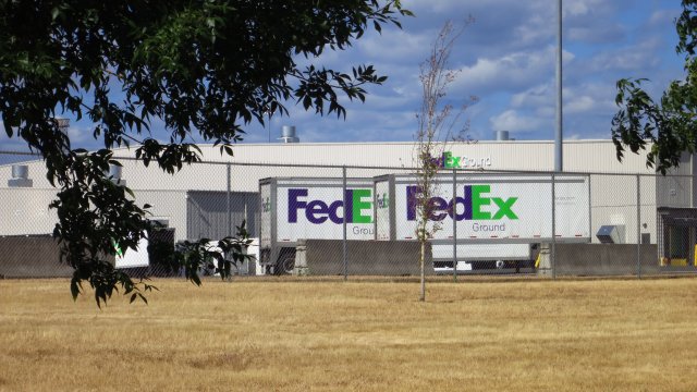
The Reynolds Metals Company Superfund site is located outside the city of Troutdale, Oregon, about 20 miles from Portland. The site consists of an 80-acre former aluminum smelter and the surrounding 700 acres. Sampling found contamination in groundwater, surface water, sediments and soils on-site. EPA added the site to the National Priorities List in 1994. From 1995 to 2008, Reynolds Metal Company completed most cleanup actions at the site. Alcoa acquired the Reynolds Metals Company in 2000, began demolishing the plant in 2003, and sold the property to the Port of Portland in 2007. Although the Port now owns the site, Alcoa remains responsible for ongoing groundwater cleanup. The Port developed a three-phase master plan for the site, now called Troutdale Reynolds Industrial Park. From 2008 to 2010, the Port implemented the first phase of the master plan, making 131 acres of the site available for reuse. The Port of Portland sold a 78-acre parcel to FedEx Ground, which built a 441,000-square-foot regional distribution center. The $200 million center opened in October 2010. The Port implemented the second phase of the master plan in 2015, opening up more lots for sale. In early 2017, Amazon purchased 74 acres of the site property from the Port. In 2018, Amazon opened a $178.4 million, 855,000-square-foot distribution center. The third phase of the master plan called for the development of an additional 34.5 acres into an industrial and logistics facility known as The Cubes. The Port set aside the rest of the land for infrastructure, open space, wetlands and a recreation trail. In 2010, the Port received a national Phoenix Award for achievement of excellence in Superfund site reuse. In 2018, EPA’s Region 10 presented its Howard Orlean Excellence in Site Reuse Award to the Port in recognition of its efforts as part of a diverse group of stakeholders who have made redevelopment possible. In 2019, EPA recognized the Oregon Department of Environmental Quality with its State Excellence in Supporting Reuse Award for its support of the site’s cleanup and reuse.
Last updated October 2025
As of December 2025, EPA had data on 4 on-site businesses. These businesses employed 5,226 people and generated an estimated $1,995,984,243 in annual sales revenue. For additional information click here.
For more information:
- Reynolds Metals Company Superfund Site - Before and After
- Reuse and the Benefit to Community: A Beneficial Effects Economics Case Study for the Reynolds Metals Company Superfund Site (PDF)
- Site Redevelopment Profile: Reynolds Metals Company Superfund Site (PDF)
- EPA Region 10 Howard Orlean Excellence in Site Reuse Award
- Superfund Site Profile Page
TAYLOR LUMBER AND TREATING
The Taylor Lumber and Treating Superfund site is in Sheridan, Oregon. From 1966 to 2001, Taylor Lumber and Treating pressure treated logs for use as utility poles and pilings. Drips, spills and leaks of wood-treating chemicals resulted in groundwater and soil contamination at the site and in nearby roadside ditches. The facility ceased operations and filed for bankruptcy in 2001. EPA added the site to the National Priorities List that same year. In 2008, EPA completed remedial cleanup actions. Cleanup included removal and off-site disposal of contaminated soils from nearly 5 acres of the site, repair and reconstruction of existing asphalt pavement within the barrier wall area, drainage modifications within the existing paved area within the barrier wall area, and installation of a low permeability asphalt cap over the existing paved area. EPA restricted groundwater use and non-industrial land uses at the site. Groundwater treatment is ongoing. The state of Oregon is responsible for long-term groundwater monitoring and oversight of maintenance of a low-permeability asphalt cap in the treatment area. In 2002, Pacific Wood Preserving of Oregon (PWPO) entered into a Prospective Purchaser Agreement with EPA and purchased the 40-acre wood-treating facility. In 2011, EPA updated the agreement. In 2013, Stella-Jones Corporation and McFarland Cascade Holdings purchased the PWPO facility. The facility currently makes transmission poles, telephone and utility poles, distribution poles and laminated beams.
Last updated October 2025
As of December 2025, EPA had data on one on-site business. This business employed 36 people. For additional information click here.
For more information:
TELEDYNE WAH CHANG
The Allegheny Technologies Incorporated Millersburg Operations (ATI) (formerly Oremet Wah Chang and Teledyne Wah Chang) plant is in Millersburg, Oregon. The facility is one of the country's largest producers of rare earth metals and alloys. The Teledyne Wah Chang Superfund site includes the 110-acre plant, a 115-acre Farm Ponds Area made up of four ponds formerly containing sludges from the plant's wastewater treatment facility, and a 60-acre Soil Amendment Area field with sludges containing radium for soil amendment. Production at the site began in 1957. Past disposal practices resulted in the contamination of soil, sediments and groundwater. EPA added the site to the National Priorities List in 1983. Between March 1989 and 1990, the SAA transferred to the city of Millersburg (the City) through a deed agreement between the OWC Company and the City. The City acquired the 40-acre SAA and ATI acquired property next to its Farm Ponds Area. Institutional controls requiring that land use remain consistent with current industrial zoning are in place. ATI completed cleanup actions for contaminated sediment sand soil in 1999. In 2000, ATI began operating a groundwater treatment system. It continues to extract and treat groundwater. With EPA’s approval, ATI enhanced the system in 2009, adding microbes-based remediation technologies. The ATI plant remains active on-site.
Last updated October 2025
As of December 2025, EPA had data on one on-site business. This business employed 1,172 people and generated an estimated $663,625,974 in annual sales revenue. For additional information click here.
For more information: