
Superfund Sites in Reuse in South Dakota
If you are having trouble viewing the map in your browser, click the 'View larger map' link below
GILT EDGE MINE
The Gilt Edge Mine site is about 6.5 miles east of Lead, South Dakota. The main mine area includes: A former open pit mine, a cyanide heap-leach gold mine, and areas disturbed by earlier mine exploration In the late 1990s, the most recent operator, Brohm Mining Company (BMC), abandoned the site. They also stopped treating the acidic water (acid rock drainage, or ARD) that forms when rain and snow hit exposed rock walls and waste piles. The site still produces this polluted water from open mine pits and exposed waste rock and spent ore. Mining and mineral processing at the site began in 1876 when the Gilt Edge and Dakota Maid mining claims were located. Sporadic mining by numerous operators took place at the site until the early 1920s. Early gold miners did some mining on the surface and also created a large network of tunnels underground that run through the middle of the site. Between 1935 and 1941, the mines were actively producing, and more tunnels were added underground. Then, in 1976, a big project began to see if gold or other minerals could be mined. In 1986, BMC commenced development of a large-scale open pit, cyanide heap leach gold mine operation. In July 1999, BMC abandoned the site and their on-going treatment of ARD. Historical operations at the site contaminated surface water and groundwater with ARD. Investigation and cleanup activities at the site are ongoing. Interim remedies are currently in place for two of the site’s three areas. Remedial action construction is in progress for the third area.
Last updated October 2025
As of December 2025, EPA did not have economic data related to on-site businesses, or economic data were not applicable due to site use. For additional information click here.
For more information:
WHITEWOOD CREEK
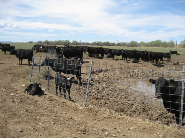
The Whitewood Creek Superfund site covers an 18-mile stretch of Whitewood Creek in Lawrence, Meade and Butte counties in South Dakota. Starting in the 1870s, area gold mining operations sent millions of tons of mine tailings into Whitewood Creek. They contaminated soil, groundwater and surface water. EPA added the site to the National Priorities List in 1983. The potentially responsible party, Homestake Mining Company, cleaned up the site by removing and replacing contaminated soil from residential yards. EPA took the site off the NPL in 1996. About 83% of the site remains forested and provides habitat for wildlife. Whitewood Creek is a water source for irrigation, livestock and recreation. Residents along Whitewood Creek continue to raise livestock and crops for livestock feed on-site, as they have for more than 40 years. Whitewood Creek banks are now revegetated. Parts of the site are in reuse as ranchland. Residents also use the creek for recreation.
Last updated October 2025
As of December 2025, EPA did not have economic data related to on-site businesses, or economic data were not applicable due to site use. For additional information click here.
For more information:
WILLIAMS PIPE LINE CO. DISPOSAL PIT
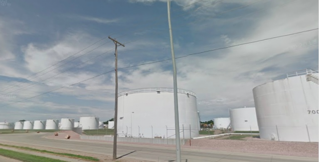
The 52-acre Williams Pipe Line Co. Disposal Pit Superfund site is in Sioux Falls, South Dakota. The Great Lakes Pipeline company opened a facility on-site in 1945. The Williams Pipeline Company (now Magellan Pipeline Company) bought the property in 1966. The companies stored and conveyed liquid fertilizers and petroleum products at the facility. These materials included fuel oil, diesel fuel, unleaded gasoline, aviation gasoline and jet fuel. Tanks and pipe racks moved petroleum fuel to loading racks to fill delivery vehicles. A burn pond, or disposal pit, was constructed in the northeast corner of the terminal in 1945. It collected stormwater runoff from terminal areas until 1987. The stormwater runoff was often contaminated with spilled materials. Petroleum products accumulating on the pond surface were burned off periodically. These activities contaminated groundwater with hazardous chemicals. EPA added the site to the National Priorities List in 1990. Cleanup included putting in recovery trenches along site boundaries to capture contamination and prevent contaminated groundwater from moving off-site. The remedy also included groundwater monitoring. Remedy construction finished in 1994. After the site met cleanup goals, EPA took the site off the NPL in 1999. The site remains in continued industrial use. The Magellan Pipeline Company Terminal includes 42 aboveground petroleum storage tanks, a fuel loading area, garages and an administration building.
Last updated October 2025
As of December 2025, EPA had data on one on-site business. This business employed 10 people and generated an estimated $5,879,000 in annual sales revenue. For additional information click here.
For more information: