
R1 Success Story: Belle Isle Salt Marsh, Boston, Mass.

EPA Grant Recipient:
Boston Redevelopment Authority
Grant Types:
cleanup
Current Use:
salt marsh preservation
Download Success Story:
Belle Isle Salt Marsh (Boston, Mass.) (pdf)
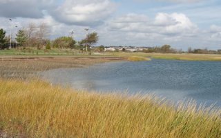
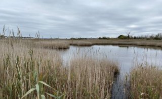
The 359-acre Belle Isle Marsh in Boston, Revere, and Winthrop is the largest remaining salt marsh in Boston. Located along the Atlantic Flyway, birders have documented 265 species of birds, including seven state-listed birds that are endangered, threatened, or are a species of special concern using the marsh for breeding, migration stopover, and overwintering habitat. In 1988, the marsh was designated an Area of Critical Environmental Concern by the Commonwealth of Massachusetts along with the larger 1260-acre Rumney Marsh, which is in Lynn, Revere, and Saugus.
Boston and many other coastal cities historically filled in natural wetlands as they grew in population. Marshes like Belle Isle provide a barrier against strong winds and waves that come from hurricanes and other storms. When hurricanes hit, strong waves get pushed into shorelines and high winds blow over the sea, both are slowed down when passing through barriers, natural or man made. As sand and dirt are naturally moved over time, they can barriers that help soften the impacts of strong waves and high winds. The robust plant growth in salt marshes keeps these barriers together and minimizes erosion. Keeping living shorelines and coastal wetlands intact will keep cities and towns along the coast safer when they are hit by extreme weather and natural disasters.
The protection and restoration of Belle Isle Marsh is important as it helps protect against flooding and will potentially play a role in the city’s resiliency efforts as Boston prepares for extreme weather and the expected sea level rises that come with it.
Starting in 1996, and completed in 2002, a salt marsh restoration plan was developed by a host of stakeholders including state, local, federal agencies and non-profits. One of these projects was the site of the former Belle Isle Fish Company. EPA's Brownfields program is among the federal state, and local partners who came together to protect and enhance Belle Isle through a $1.5 million project that brought a unique and welcoming recreation area to land once contaminated by industry.
Background
The Belle Isle Marsh was the home to the Belle Isle Fishing Company from 1978 until it closed in about 1991. The company used the area to support its fishing and seafood distribution operations. Once the company left, the vacant 1.6-acre property at the entrance to the marsh became a nuisance and subject to dumping of waste from nearby construction projects. These wastes included contaminants such as asbestos, petroleum, lead, and polycyclic aromatic hydrocarbons, or PAHs, which can make the property unsafe for people to use and threaten the health of the marsh. In 1991, the City of Boston took ownership of the property with the goal of cleaning it up and transforming it into a safe and welcoming public access point for the marsh.
From 1995 to 2001, the city assessed the property to get a clear picture of how much waste had been dumped there and how contaminated the area had become. The city's Parks and Recreation Department during this time developed partnerships with the Mass. Department of Conservation and Recreation, the Boston Redevelopment Authority, and Friends of Belle Isle Marsh. In 2004, the Boston Redevelopment Authority won a $200,000 EPA Brownfields cleanup grant to dispose of hazardous contaminants from this property at the entrance to the marsh. As is often the case, EPA's funding was only one piece of the puzzle.
The city invested $393,000 to help with the cleanup, which ultimately meant removing nearly 8,600 cubic yards of contaminated soil. Some clean debris was able to be re-used on site in creating a walkway.
After the cleanup, the National Marine Fisheries Service awarded a $55,000 grant, matched by another $60,000 from the city, to help improve the overall health of the marsh. This project included breaching formerly constructed dikes to restore tidal flows to the marsh and planting native salt marsh vegetation.
This $1.5 million collaborative project bringing together the city, Friends of Belle Isle Marsh, the Woods Hole Group, the Nature Conservancy, and the Mass. Department of Conservation and Recreation will be the first step toward establishing a comprehensive management plan for the marsh.
"The Belle Isle Marsh stands as the last major salt marsh in Boston, and it is our continued mission to protect it. Through our collective ongoing stewardship efforts, the Belle Isle Coastal preserve site has become an important part of the community and the larger Belle Isle estuary. The success the project will long be remembered for the effective advocacy of groups like the Friends of Belle Isle Marsh as well as the extensive partnerships created between the grant, permitting, development and transit agencies involved; together, all hands on deck lead to a successful outcome in restoring this area."
Paul Sutton
Urban Wilds Program Manager, Boston Parks & Recreation Dept.
Today

In addition to providing vital wildlife habitat and a buffer against hurricanes and extreme weather, the marsh is now a popular open space used for recreation. A parking lot and trailhead provide access to the trails that go through the preserve. The Massachusetts Bay Transportation Authority supports the preserve, collecting trash, managing vegetation, and monitoring erosion to help keep the trails and walkways clean. The park is popular amongst birders because of its unique ecosystem, which is home to 265 species, including seven listed species that spend some or all their life cycles there. People frequent the area for nature walks, fishing, jogging, and even picnics. The U.S. Fish and Wildlife Service recognizes Belle Isle Marsh as one of the most biologically significant estuaries north of Boston, and the National Audubon Society recognizes it internationally as an Important Bird and Biodiversity Area. The Friends of Belle Isle Marsh regularly host events inviting people to enjoy the beauty of the marsh. A local school, Knowledge Link, uses the park as an outdoor classroom to teach children about the natural world around them. The State awarded the Mystic River Watershed Association a $30,000 Healthy Estuaries grant in July 2020 to inventory environmental conditions of the marsh.
Commercial and recreational fishing are central to New England’s history and cultural heritage. Many species of fish lay eggs in protected areas like salt marshes as an important part of their life cycle. These habitats provide safe havens to eggs, smaller fish species, and developing fish juveniles because larger fish and other predators are too big to swim through the thick marsh grasses. Protecting and preserving marshes such as Belle Isle is vital to maintaining and restoring the fish populations, which provide food, recreation, and commercial fishing opportunities.
For more information:
Visit the EPA Brownfields website at www.epa.gov/brownfields or contact William Lariviere, (617) 918-1231 and lariviere.william@epa.gov.
EPA 901 F 21 003
February 2021