
U.S. Gridded Methane Emissions
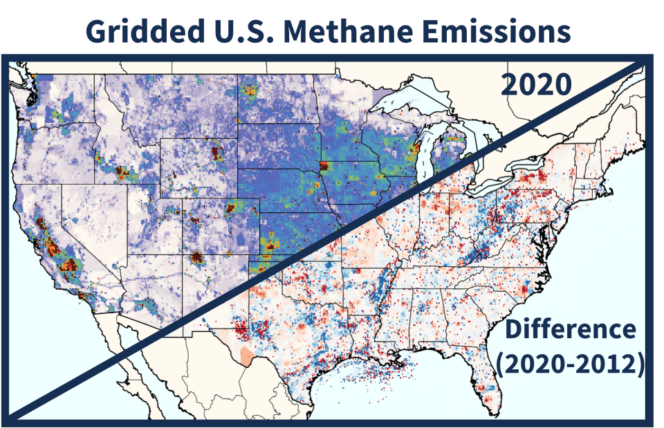
The gridded EPA U.S. methane greenhouse gas inventory (gridded methane GHGI) includes time series of annual methane emission maps with 0.1° x 0.1° (~ 10 x 10 km) spatial and monthly temporal resolution for the contiguous United States (CONUS). This gridded methane inventory is designed to be consistent with methane emissions from the U.S. EPA Inventory of U.S. Greenhouse Gas Emissions and Sinks (U.S. GHGI).
The gridded methane GHGI dataset includes annual methane emission fluxes for over 25 inventory emission source categories, including those from agriculture, petroleum and natural gas systems, coal mining, and waste. Gridded methane emissions data are generated by allocating national annual U.S. GHGI methane emissions from individual source categories to a 0.1° x 0.1° CONUS grid, using a series of spatial and temporal 'proxy' datasets at the state, county, and grid levels. Where possible, proxy data are the same data used to develop the U.S. GHGI so that the gridded emissions can be, as closely as possible, a spatial and temporal representation of the national-level U.S. GHGI. Monthly scaling factors are also provided for a subset of emissions categories with strong temporal variation (e.g., manure management, petroleum and natural gas production, etc.).
The gridded methane GHGI dataset can be used by researchers to better compare the national U.S. GHGI with emission estimates from more regional and local observations of atmospheric methane. Users of the gridded GHGI are asked to cite the original reference (Maasakkers et al., 2023) in their publications. Error estimates are also described in that reference. Manuscripts describing the gridded GHGI have been peer-reviewed, but are not part of the same annual expert and public review processes as the U.S. EPA National and State-level Inventory.
Data Version Details
The gridded methane GHGI is continually updated to capture ongoing improvements and updates to the national U.S. GHGI. The gridded GHGI currently includes 2 versions, each of which reflect sectoral methane emissions that are consistent with different versions of the U.S. GHGI. Versions include:
Current Version(s)
Gridded methane GHGI Version 2
Published in 2023
Emission Year(s): 2012 – 2018
Resolution: 0.1°×0.1° spatial, annual & monthly temporal
Consistent with the 2020 U.S. GHGI
Reference: Maasakkers et al., 2023
Data Download
Gridded methane GHGI Version 2 - Express Extension
Published in 2023
Emission Year(s): 2012 – 2020
Resolution: 0.1°×0.1° spatial, annual temporal
Consistent with the 2022 U.S. GHGI
Reference: Maasakkers et al., 2023
Data Download
Note: This dataset is not a full update to the main v2 gridded GHGI (above), and instead uses annual source-specific spatial patterns from the main product to allocate methane emissions from a more recent version of the U.S. GHGI, across an extended time series. This allows for publication of gridded emissions data that reflect more recent inventory data, in the interim, before a full update to v3 is complete. More information is available on the Data Download page.
Previous Versions
Gridded methane GHGI Version 1
Published in 2016
Emission Year(s): 2012
Resolution: 0.1°×0.1° spatial, annual & monthly temporal
Consistent with the 2016 U.S. GHGI
Reference: Maasakkers et al., 2016
Data Download
External Resources
This dataset will also be featured on the upcoming U.S. Greenhouse Gas Information Center. Visit the ‘Explore Data’ tab on the US GHG Center site to create and view custom maps of the gridded methane GHGI v2 – Express Extension dataset.
Acknowledgements
This dataset was developed in collaboration between researchers at the U.S. EPA, SRON Netherlands Institute for Space Research, Harvard University, and Lawrence Berkeley National Laboratory.