U.S. flag

An official website of the United States government

Here’s how you know

Dot gov

Official websites use .gov
A .gov website belongs to an official government organization in the United States.

HTTPS

Secure .gov websites use HTTPS
A lock (LockA locked padlock) or https:// means you’ve safely connected to the .gov website. Share sensitive information only on official, secure websites.

    • Environmental Topics
    • Air
    • Bed Bugs
    • Chemicals, Toxics, and Pesticide
    • Emergency Response
    • Environmental Information by Location
    • Health
    • Land, Waste, and Cleanup
    • Lead
    • Mold
    • Radon
    • Research
    • Science Topics
    • Water Topics
    • A-Z Topic Index
    • Laws & Regulations
    • By Business Sector
    • By Topic
    • Compliance
    • Enforcement
    • Guidance
    • Laws and Executive Orders
    • Regulations
    • Report a Violation
    • Environmental Violations
    • Fraud, Waste or Abuse
    • About EPA
    • Our Mission and What We Do
    • Headquarters Offices
    • Regional Offices
    • Labs and Research Centers
    • Planning, Budget, and Results
    • Organization Chart
    • EPA History

Breadcrumb

  1. Home
  2. Navajo Nation: Cleaning Up Abandoned Uranium Mines
  3. Abandoned Mines Cleanup
  4. WESTERN REGION

Section 9 Lease Mines

Background | Documents | Timeline | Cleanup Progress Timeline | Contact | Photos

Background

The Section 9 Lease Mines are three abandoned uranium mine sites located near the Little Colorado River in Northern Arizona. The mines are located just outside the Navajo Nation and are about 10 miles southeast of Cameron, AZ. Under a 2016 Administrative Order on Consent (AOC), Babbitt Ranches completed a Removal Site Evaluation on the two mines on their property.

The Section 9 Lease Mines were operated in the late 1950s and early 1960s and include Abandoned Uranium Mines (AUM) 457, 458, and 459. The mines are located about 10 miles southeast of the Cameron, AZ, and are away from population centers. AUM 457, the farthest north of the three sites, also includes a concrete structure called an “upgrader”, which was meant to increase the concentration of uranium in the ore from local mines. AUM 457 is a priority mine site based on its potential impacts on the Little Colorado River.

In 2016, EPA signed a legal agreement called an Administrative Order on Consent with Babbitt Ranches. In this document, Babbitt Ranches agreed to place warning signs and perform an assessment called a Removal Site Evaluation on AUMs 457 and 458. AUM 458 is entirely on Babbitt Ranches property, while AUM 457 is partially on Babbitt Ranches property and partially on land administered by the Bureau of Land Management. Babbitt Ranches also agreed to investigate whether contamination from AUM 459 is now located on their property. The work under this Administrative Order on Consent was completed in 2021.

EPA presented an Environmental Engineering/ Cost Analysis (EE/CA) to the community in November of 2024.  The EE/CA compared potential clean up alternatives and recommended a clean up alternative for the Site, the presentation of the EE/CA to the community began the public comment period.

In September 2025, after careful consideration of all received comments, EPA signed an Enforcement Action Memorandum (Action Memo) to move forward with the recommended clean up alternative. The clean up action includes the removal of waste from the banks of the Little Colorado River to a designed repository one mile away and restoration of the site. Design is expected to begin in 2026.

EPA remains committed to providing information to Chapter officials, community members, and other interested individuals and will provide updates to the community through the design and clean up phases.

Cleanup Progress Timeline

The Section 9 Lease mines were operated in the 1950s and 1960s. Under the 2016 Administrative Order on Consent, Babbitt Ranches agreed to perform assessments at the two abandoned uranium mine sites on their property. Learn about recent and upcoming activities in the timeline below.

2025

In September 2025, EPA signed an Action Memo to move forward with clean up and design of a repository on Section 9, which is expected to begin in 2026.

2024

  • On November 23, 2024, in a public meeting, EPA released the final Section 9 Lease mines Engineering Evaluation/Cost Analysis (EE/CA) (pdf) (328 pp, 26.94 MB) with a recommended cleanup alternative for the Section 9 Lease Sites.

2017

  • Babbitt Ranches completes cultural and biological clearances ahead of site work
  • Babbitt Ranches places warning signs at the sites
  • Babbitt Ranches begins gamma radiation and background studies

2016

EPA signs a legal agreement with Babbitt Ranches to perform assessments on mines on their property

2014

EPA completes a Site Inspection of the Section 9 Lease abandoned uranium mines

2012

EPA completes a Preliminary Assessment of the Section 9 Lease abandoned uranium mines

DANGER - KEEP OUT with radiological symbol.
Warning sign placed in front of a waste pile at AUM 457 | Click image to enlarge.

Site Facts

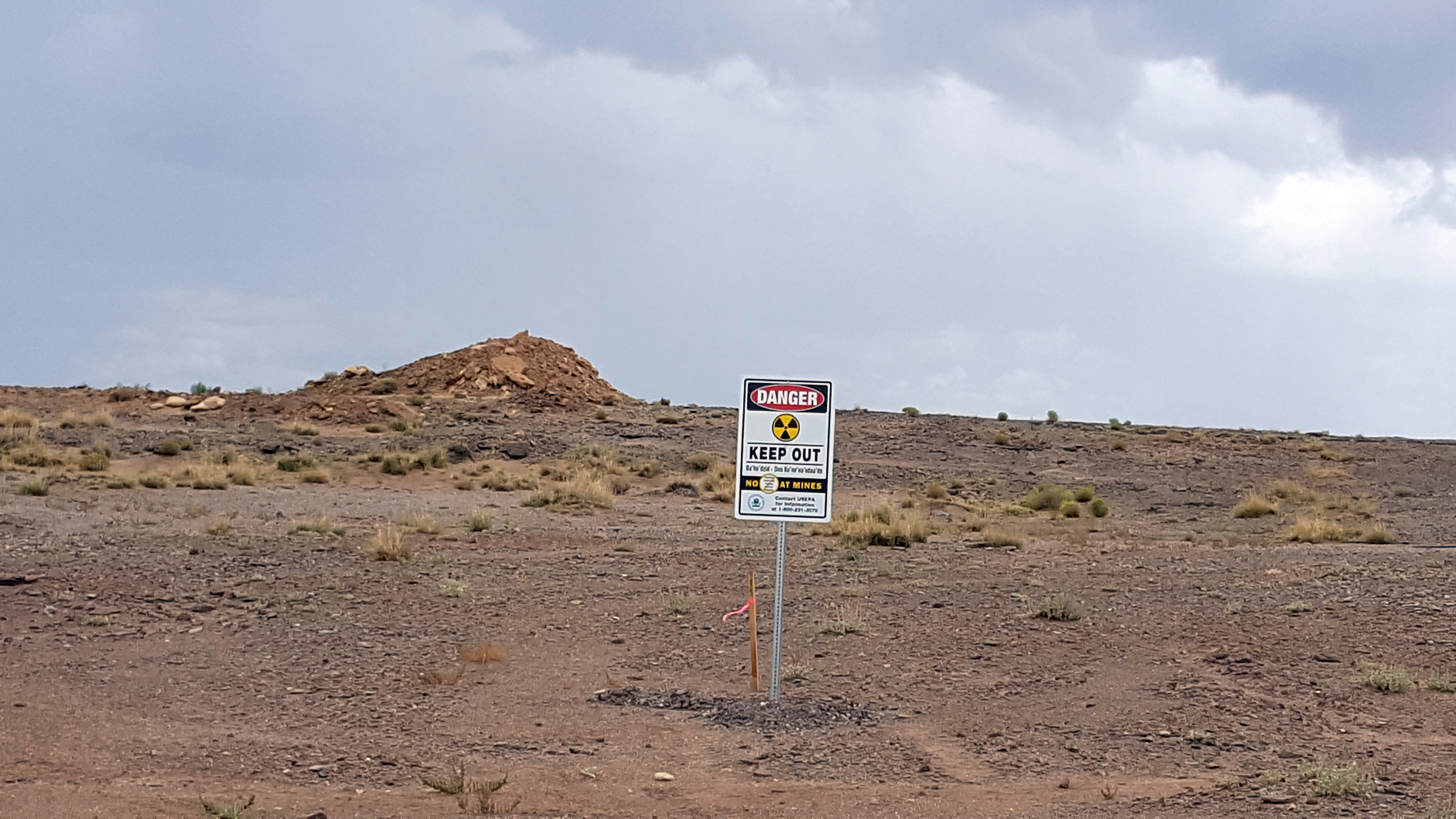
  • The Section 9 Lease mines are three separate abandoned uranium mines, the assessment and cleanup addresses AUM 457, AUM 458 and the portion of AUM 459 that has migrated to Section 9 property.
  • The remnants of a concrete structure called an “upgrader” remain on the furthest north site.
  • Babbitt Ranches is responsible for the mines on their property.

Site Documents

  • Action Memo
  • Administrative Record
  • Engineering Evaluation/Cost Analysis (EE/CA) (pdf) (328 pp, 26.94 MB)
  • Section 9 Lease AUM Map (pdf) (163.12 KB, 11/2012)
  • Legal Documents and Settlements
  • Technical Reports
  • Fact Sheets (Western AUM Region)

Site Contacts

Remedial Project Manager: Estrella Armijo
armijo.estrella@epa.gov
(415) 972-3859

Community Involvement Coordinator: Michele Dineyazhe
dineyazhe.michele@epa.gov
(928) 310-4854

Site Photographs

The Section 9 Lease Mines are three abandoned uranium mines sites located near the Little Colorado River in Northern Arizona. The mines are located just outside the Navajo Nation and are about 10 miles southeast of Cameron, AZ. Under a 2016 Administrative Order on Consent, Babbitt Ranches agreed to perform a Removal Site Evaluation on the two mines on their property.

Section 9 Lease Mines
  • Desert landscape with small hills

    One of the waste piles remaining on site at AUM 457.

  • Desert vista with "Warning: Keep Out" sign, concrete wall in mid photo and concrete pad in foreground

    A warning sign placed near the upgrader structure on AUM 457.

  • DANGER - KEEP OUT with radiological symbol.

    A warning sign placed in front of a waste pile at AUM 457.

  • Warning sign in sandy soil in front of brush with opposite bank of river visible in the distance.

    Warning sign placed near the Little Colorado River.

  • Concrete walled structure in a desert setting

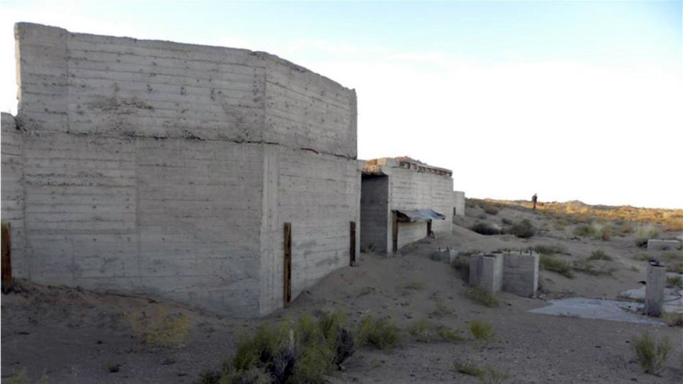
    The remnants of a concrete structure called an “upgrader”, which was meant to increase the concentration of uranium in the ore from local mines.

Navajo Nation: Cleaning Up Abandoned Uranium Mines

  • Abandoned Mines Cleanup
    • CENTRAL REGION
      • Community Involvement Plans
      • CYPRUS AMAX & WESTERN NUCLEAR MINES
      • BLACK MESA MINING DISTRICT
    • EASTERN REGION
      • Community Involvement Plans
      • Fact Sheets
      • AMBROSIA LAKE MINES (TRONOX)
      • CYPRUS AMAX & WESTERN NUCLEAR MINES
      • HAYSTACK #1 MINE
      • MAC AND BLACK JACK MINES
      • MARIANO LAKE MINE (Old Gulf Mine)
      • NORTHEAST CHURCH ROCK MINE
      • OLD CHURCH ROCK MINE
      • QUIVIRA MINES
      • RUBY MINES
      • SECTION 32/33 MINES (TRONOX)
    • NORTH CENTRAL REGION
      • SKYLINE MINE
      • Community Involvement Plan
    • NORTHERN REGION
      • Community Involvement Plans
      • COVE AREA MINES
      • LUKACHUKAI MOUNTAINS MINING DISTRICT
      • CYPRUS AMAX & WESTERN NUCLEAR MINES
    • WESTERN REGION
      • Community Involvement Plans
      • Fact Sheets
      • Maps
      • EL PASO NATURAL GAS MINES
      • ENPRO MINES
      • SECTION 9 LEASE MINES
    • SUPERFUND NPL SITES (Lukachukai)
  • Administrative Records
  • ASPECT Aerial Survey
  • Atlas Screening Assessment Report
  • Community Involvement Plans
  • Contaminated Structures Program
  • Fact Sheets
  • Interactive Map
  • Legal Documents and Settlements
    • TRONOX MINES
      • Fact Sheets
      • Financial Reports
      • Northern Agency RSE Report
    • TRUST MINES
      • Fact Sheet
      • Legal Document and Settlements
      • Technical Reports
  • Site Screen Reports
  • Ten-Year Plan (2020-2029)
    • Related Documents
  • Treatment Technology Pilot Studies
  • Health Effects of Uranium
    • Water Sampling Results
  • Contracting With EPA
    • Navajo Workforce Development
    • RAES Employment and Training Reports
Contact Us
Contact Us to ask a question, provide feedback, or report a problem.
Last updated on October 14, 2025
  • Assistance
  • Spanish
  • Arabic
  • Chinese (simplified)
  • Chinese (traditional)
  • French
  • Haitian Creole
  • Korean
  • Portuguese
  • Russian
  • Tagalog
  • Vietnamese
United States Environmental Protection Agency

Discover.

  • Accessibility Statement
  • Budget & Performance
  • Contracting
  • EPA www Web Snapshot
  • Grants
  • No FEAR Act Data
  • Plain Writing
  • Privacy and Security Notice

Connect.

  • Data
  • Inspector General
  • Jobs
  • Newsroom
  • Regulations.gov
  • Subscribe
  • USA.gov
  • White House

Ask.

  • Contact EPA
  • EPA Disclaimers
  • Hotlines
  • FOIA Requests
  • Frequent Questions
  • Site Feedback

Follow.